Weather Forecast Outlook for 23 May 2018 – 20 Jun 2018 (10am, Mon, 5/21/18)

— Written By Barclay Poling
en Español / em Português
Español

El inglés es el idioma de control de esta página. En la medida en que haya algún conflicto entre la traducción al inglés y la traducción, el inglés prevalece.

Al hacer clic en el enlace de traducción se activa un servicio de traducción gratuito para convertir la página al español. Al igual que con cualquier traducción por Internet, la conversión no es sensible al contexto y puede que no traduzca el texto en su significado original. NC State Extension no garantiza la exactitud del texto traducido. Por favor, tenga en cuenta que algunas aplicaciones y/o servicios pueden no funcionar como se espera cuando se traducen.


Português

Inglês é o idioma de controle desta página. Na medida que haja algum conflito entre o texto original em Inglês e a tradução, o Inglês prevalece.

Ao clicar no link de tradução, um serviço gratuito de tradução será ativado para converter a página para o Português. Como em qualquer tradução pela internet, a conversão não é sensivel ao contexto e pode não ocorrer a tradução para o significado orginal. O serviço de Extensão da Carolina do Norte (NC State Extension) não garante a exatidão do texto traduzido. Por favor, observe que algumas funções ou serviços podem não funcionar como esperado após a tradução.


English

English is the controlling language of this page. To the extent there is any conflict between the English text and the translation, English controls.

Clicking on the translation link activates a free translation service to convert the page to Spanish. As with any Internet translation, the conversion is not context-sensitive and may not translate the text to its original meaning. NC State Extension does not guarantee the accuracy of the translated text. Please note that some applications and/or services may not function as expected when translated.

Collapse ▲
Dear Agents, Agronomists, Growers and Friends,
After a period of widespread showers/ thunderstorms with above normal temperatures and high humidity early this upcoming week, things  start to dry out and cool down a bit  by mid week as slightly cooler and drier air moves into the forecast area region.  For the remainder of May temperature will likely average out near normal with precipitation near to  slightly below normal.
Both the long range statistical models and dynamically based models are now indicating June will be above normal in temperature (1-2 F) and precipitation amounts (25-50% above normal). Looking at the state of the large scale forcing  mechanisms  now in place we agree with  this model assessment.
 Looking  past June, the major long term factor appears to be a developing El Nino. Statistically for the forecast region, El Nino years tend to have summers that are somewhat cooler and drier than normal. The most significant statistical correlation El Niño has on the summer weather in the eastern United States is the relative lack of tropical storms hurricanes that form during El Niño years. This effect significantly decreases the chance for heavy rains in the Eastern US due to tropical systems,
Note: This will be the last weather forecast outlook of the 2017-2018 strawberry season,  and we wish to extend our sincere thanks to the individual strawberry growers, private consultants and Cottle Strawberry Nursery, who all chipped in to sponsor this public service for the benefit of the whole industry! Thank you!
Best wishes for a Happy Memorial Weekend!
Forecast discussion day 3 – 5   (23 May – 25 May) Temperatures slightly above seasonal average; widely scattered showers all period.  Slightly cooler and drier air moves into the forecast area region as a high pressure moves into the forecast region from the northwest. Only widely scattered light showers expected through this period with many locations remaining dry. Precipitation amounts will likely be 0.00 – 0.15”.
Image of forcast map day 3-5

Temperature Forecast and Climatology:   

Region and Rep Station Fcst High T Range Climo High T   Fcst Low T Range Climo Low T
Reg 1    Richmond VA   80-84 79 55-62 60
Reg 2    VA Beach  VA   75-80 77 61-67 62
Reg 3    Clayton NC      82-85 82 60-66 60
Reg 4    Jackson NC       82-84 82 66-68 63
Reg 5    Greenville SC   84-86 82 66-68 62
Forecast discussion day 6 – 8:  (26 May – 28 May) Temperatures stay slightly above normal; widespread showers and thunderstorms expected mid to late in period. Expect a cold frontal system to slowly move through the area over this period. Temperatures remain slightly above normal but the chances of widespread showers and thunderstorms increases significantly by mid to late in the period. Precipitation amounts likely in the 0.35– 0.75” range with some locations possibly receiving higher amounts.

Image of forcast map day 6-8Temperature Forecast and Climatology:   

Region and Rep Station Fcst High T Range Climo High T   Fcst Low T Range Climo Low T
Reg 1    Richmond VA   84-87 80 67-69 60
Reg 2    VA Beach  VA   80-85 77 67-71 63
Reg 3    Clayton NC      83-86 82 60-70 61
Reg 4    Jackson NC       81-85 82 69-73 64
Reg 5    Greenville SC   81-85 83 68-70 63
Forecast discussion day 9 – 11:  (29 May – 31 May) Temperatures start near normal then fall to below normal by mid period. Widespread showers in eastern section early in the period with mostly dry conditions all regions by mid period.  After a cool start, expect warmer air to continue to move into the forecast area as a high pressure system moves east of the region. Slight chance of showers late in the period for western parts of regions 1 and 5 as a weather system slowly approaches from the west. Precipitation amounts will likely be 0.00 – 0.10” range.

Image of forcast map day 9-11Temperature Forecast and Climatology:   

Region and Rep Station Fcst High T Range Climo High T   Fcst Low T Range Climo Low T
Reg 1    Richmond VA   80-81 81 55-62 61
Reg 2    VA Beach  VA   77-80 79 60-64 64
Reg 3    Clayton NC      70-80 83 59-64 62
Reg 4    Jackson NC       80-83 82 63-65 64
Reg 5    Greenville SC   78-83 83 60-63 64
Forecast discussion day 12 – 14:   (1 Jun –3 Jun) Temperatures start slightly below normal then warm to near normal all regions; mostly dry this period with only a chance of showers late in period for region 1. Expect high pressure to dominate the weather during the forecast period which will allow for a slow warming trend from slightly below normal to near normal temperatures during the period. Expect mostly dry conditions for the entire period with only a slight chance of showers in regions very late in the period. Expect most locations to remain dry with precipitation amounts likely be in the 0.00– 0.10” range.
Image of forcast map day 12-14

Temperature Forecast and Climatology:   

Region and Rep Station Fcst High T Range Climo High T   Fcst Low T Range Climo Low T
Reg 1    Richmond VA   81-85 82 53-59 62
Reg 2    VA Beach  VA   75-80 80 57-63 64
Reg 3    Clayton NC      82-85 84 55-62 63
Reg 4    Jackson NC       80-85 83 60-65 65
Reg 5    Greenville SC   80-84 84 60-65 65
Outlook discussion day 15 – 22:   (4 Jun – 10 Jun) Early indications are that temperatures will be near the seasonal average with precipitation above the seasonal average.
Outlook discussion day 23 – 30:  (11 Jun – 17 Jun) Early indications are that temperatures will be near the seasonal average with precipitation above the seasonal average.
Day 15 – 30 Temperature Outlook 4 Jun – 17 Jun
Image of temperature map day 15-30
Day 15 – 30 Precipitation Outlook 4 Jun – 17 Jun
Image of precipitation map day 15-30
Items of Interest
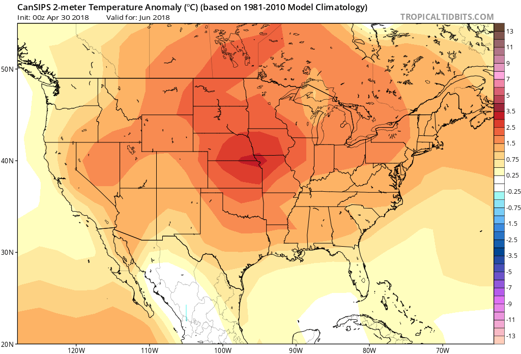
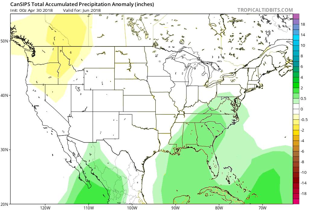
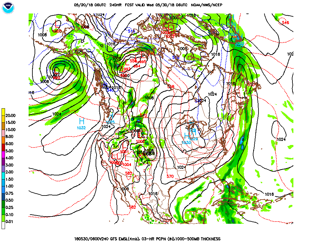
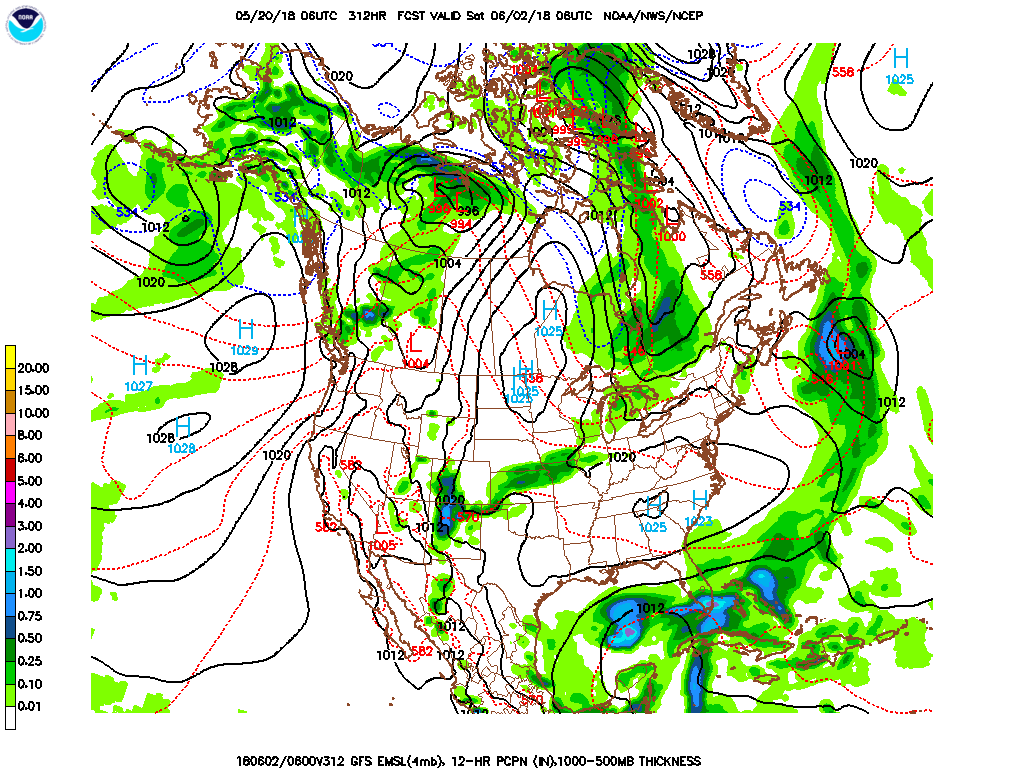
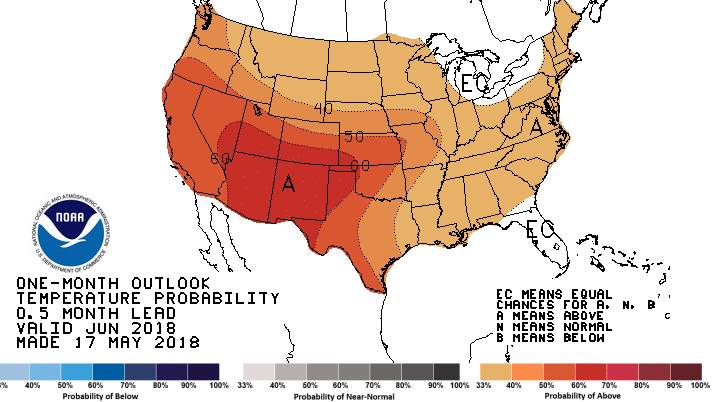
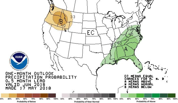
June Outlook:    The long range statistical models and dynamically based models are now indicating June will be above normal in temperature and precipitation amounts. The outlooks below give both the statistical probabilities (top row) and likely quantitative anomalies (bottom row) for temperatures and precipitation.
Image of forcast map outlook for JuneImage of forcast map outlook for June 2