


Classic “White” Frost in Forecast for Wednesday Morning in NC Foothills & Mountains, Central VA, and MD (6:30pm, Monday, April 9, 2018)
go.ncsu.edu/readext?520198
en Español / em Português
El inglés es el idioma de control de esta página. En la medida en que haya algún conflicto entre la traducción al inglés y la traducción, el inglés prevalece.
Al hacer clic en el enlace de traducción se activa un servicio de traducción gratuito para convertir la página al español. Al igual que con cualquier traducción por Internet, la conversión no es sensible al contexto y puede que no traduzca el texto en su significado original. NC State Extension no garantiza la exactitud del texto traducido. Por favor, tenga en cuenta que algunas aplicaciones y/o servicios pueden no funcionar como se espera cuando se traducen.
Português
Inglês é o idioma de controle desta página. Na medida que haja algum conflito entre o texto original em Inglês e a tradução, o Inglês prevalece.
Ao clicar no link de tradução, um serviço gratuito de tradução será ativado para converter a página para o Português. Como em qualquer tradução pela internet, a conversão não é sensivel ao contexto e pode não ocorrer a tradução para o significado orginal. O serviço de Extensão da Carolina do Norte (NC State Extension) não garante a exatidão do texto traduzido. Por favor, observe que algumas funções ou serviços podem não funcionar como esperado após a tradução.
English
English is the controlling language of this page. To the extent there is any conflict between the English text and the translation, English controls.
Clicking on the translation link activates a free translation service to convert the page to Spanish. As with any Internet translation, the conversion is not context-sensitive and may not translate the text to its original meaning. NC State Extension does not guarantee the accuracy of the translated text. Please note that some applications and/or services may not function as expected when translated.
Collapse ▲Good evening,
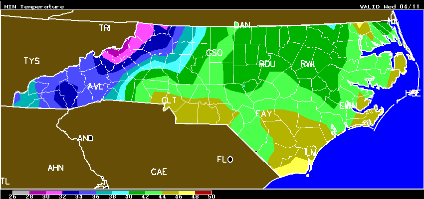
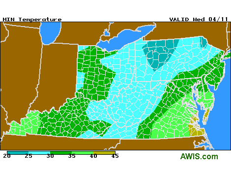
There is potential for a radiation (white) frost event this early Wednesday morning (April 11) in the NC Foothills, Mountains (Fig 1), as well as in Central VA and MD (Fig 2). Take a look at Morganton, NC Morganton Frost Wed and we can see “F” (frost) potential at 5 a.m. (with a low of 36 F). Similarly, in Ashland, VA, there is potential for frost at 5 a.m., and winds will be dead calm and skies CLEAR. If temperatures cool to 32 F, or below at strawberry canopy level, then it could definitely FROST. Ashland VA Wed
Growers in MD, DE and NJ could also be at risk for FROST this Wed morning! In Salisbury, MD, there will be a low of 37 F (weather shelter) and winds will be quite calm. AWIS is presently forecasting FROST at 5 a.m. in Salisbury.Salisbury MD Wed
 Please check the AWIS location nearest your farm for potential frost risk, and good luck! Sorry for the brevity of this advisory, but I am trying not to miss my date with the tax man!
NC
10-DAY DETAILED HOURLY WEATHER FORECASTS
MD
10-DAY DETAILED HOURLY WEATHER FORECASTS
VA
10-DAY DETAILED HOURLY WEATHER FORECASTS
Not much risk of FROST in North Carolina tonight due to CLOUDY conditions
AWIS Weather Services, Inc. North Carolina Frost/Freeze Forecast
Produced at  505 p.m. CDT on Mon Apr  9 2018

... Forecast for Tonight ... Northeast NC Coast
Currituck/Camden/Pasquotank/Tyrrell Counties

*** No Frost And/Or Freeze Danger Tonight ***

Lowest Temperatures:      43 - 50
Elizabeth_City Min          45

Extended Forecast: Range of Lowest Min Temperatures in the Above Zones
Min Temps Valid For Morning of Given Date (May NOT include ALL cold pockets)

  04/11/18  04/12/18  04/13/18  04/14/18  04/15/18  04/16/18
  --------  --------  --------  --------  --------  --------
   40 - 47   45 - 52   53 - 60   56 - 63   60 - 66   52 - 59
--------

East Central/SE NC Coast
Carteret/Pamlico Counties

*** No Frost And/Or Freeze Danger Tonight ***

Lowest Temperatures:      47 - 49
Morehead_City Min           48

Extended Forecast: Range of Lowest Min Temperatures in the Above Zones
Min Temps Valid For Morning of Given Date (May NOT include ALL cold pockets)

  04/11/18  04/12/18  04/13/18  04/14/18  04/15/18  04/16/18
  --------  --------  --------  --------  --------  --------
   42 - 46   43 - 48   52 - 55   57 - 61   63 - 65   56 - 59
--------

Southeast NC
NWS FORECAST ZONES 87-90,96-101

*** No Frost And/Or Freeze Danger Tonight ***

Lowest Temperatures:      43 - 48
Elizabethtown Min           45

Extended Forecast: Range of Lowest Min Temperatures in the Above Zones
Min Temps Valid For Morning of Given Date (May NOT include ALL cold pockets)

  04/11/18  04/12/18  04/13/18  04/14/18  04/15/18  04/16/18
  --------  --------  --------  --------  --------  --------
   41 - 46   44 - 48   51 - 55   54 - 60   61 - 66   46 - 56
--------

North-Central NC
Franklin County Area
**** LITTLE IF ANY FROST DUE TO CLOUDS ****

Lowest Temperatures:      36 - 45
Louisburg Min               36
Range Dewpoint Temps:     33 - 41
Range Wetbulb  Temps:     38 - 43
AVG Wind Direction/Speed:   V  2     Long Periods of Calm
AVG Sky Condition:         Cloudy

Extended Forecast: Range of Lowest Min Temperatures in the Above Zones
Min Temps Valid For Morning of Given Date (May NOT include ALL cold pockets)

  04/11/18  04/12/18  04/13/18  04/14/18  04/15/18  04/16/18
  --------  --------  --------  --------  --------  --------
   37 - 43   40 - 47   47 - 54   53 - 58   57 - 63   42 - 53
--------

North/Central NC
Alamance County Area
**** LITTLE IF ANY FROST DUE TO CLOUDS ****

Lowest Temperatures:      38 - 43
Graham_AG Min               41
Range Dewpoint Temps:     33 - 41
Range Wetbulb  Temps:     38 - 43
AVG Wind Direction/Speed:   V  3     Long Periods of Calm
AVG Sky Condition:         Cloudy

Extended Forecast: Range of Lowest Min Temperatures in the Above Zones
Min Temps Valid For Morning of Given Date (May NOT include ALL cold pockets)

  04/11/18  04/12/18  04/13/18  04/14/18  04/15/18  04/16/18
  --------  --------  --------  --------  --------  --------
   38 - 43   42 - 47   49 - 54   53 - 59   58 - 63   43 - 48
--------

South/Central NC
Richmond County Area

*** No Frost And/Or Freeze Danger Tonight ***

Lowest Temperatures:      43 - 45
Ellerbe Min                 45

Extended Forecast: Range of Lowest Min Temperatures in the Above Zones
Min Temps Valid For Morning of Given Date (May NOT include ALL cold pockets)

  04/11/18  04/12/18  04/13/18  04/14/18  04/15/18  04/16/18
  --------  --------  --------  --------  --------  --------
   42 - 44   44 - 47   49 - 53   55 - 58   59 - 64   45 - 51
--------

Interior/EC-SE NC
Wayne County Area

*** No Frost And/Or Freeze Danger Tonight ***

Lowest Temperatures:      43 - 46
Goldsboro_AG Min            46

Extended Forecast: Range of Lowest Min Temperatures in the Above Zones
Min Temps Valid For Morning of Given Date (May NOT include ALL cold pockets)

  04/11/18  04/12/18  04/13/18  04/14/18  04/15/18  04/16/18
  --------  --------  --------  --------  --------  --------
   41 - 43   43 - 46   50 - 53   55 - 58   60 - 64   49 - 56
--------

For more detailed information visit www.awis.com or call 888-798-9955. Copyright 2018 AWIS Weather Services, Inc. All rights reserved.
cc