Weather Advisory: Multiple Frost Events Ahead
go.ncsu.edu/readext?923384
en Español / em Português
El inglés es el idioma de control de esta página. En la medida en que haya algún conflicto entre la traducción al inglés y la traducción, el inglés prevalece.
Al hacer clic en el enlace de traducción se activa un servicio de traducción gratuito para convertir la página al español. Al igual que con cualquier traducción por Internet, la conversión no es sensible al contexto y puede que no traduzca el texto en su significado original. NC State Extension no garantiza la exactitud del texto traducido. Por favor, tenga en cuenta que algunas aplicaciones y/o servicios pueden no funcionar como se espera cuando se traducen.
Português
Inglês é o idioma de controle desta página. Na medida que haja algum conflito entre o texto original em Inglês e a tradução, o Inglês prevalece.
Ao clicar no link de tradução, um serviço gratuito de tradução será ativado para converter a página para o Português. Como em qualquer tradução pela internet, a conversão não é sensivel ao contexto e pode não ocorrer a tradução para o significado orginal. O serviço de Extensão da Carolina do Norte (NC State Extension) não garante a exatidão do texto traduzido. Por favor, observe que algumas funções ou serviços podem não funcionar como esperado após a tradução.
English
English is the controlling language of this page. To the extent there is any conflict between the English text and the translation, English controls.
Clicking on the translation link activates a free translation service to convert the page to Spanish. As with any Internet translation, the conversion is not context-sensitive and may not translate the text to its original meaning. NC State Extension does not guarantee the accuracy of the translated text. Please note that some applications and/or services may not function as expected when translated.
Collapse ▲Weather Advisory: Multiple Frost Events ahead
In collaboration with AWIS weather services
In the coming two weeks, we will experience multiple frost/freeze events in the Southeast. It will be extremely critical to closely follow the daily weather forecasts, as predicted patterns can change quickly. Potential Frost nights in NC and North are: Sunday/Monday and for most of NC, SC and GA: Monday/Tuesday and Tuesday/Wednesday.
IF you are at 10% or more bloom, you will need to protect multiple times in the coming weeks. At this point of time, we would advise row-cover use or sprinkler/overhead protection, if wind speed allow. This might apply especially for areas in Eastern NC, the Piedmont as well as SC and GA: Protection from Monday to Wednesday, potentially Thursday coming week will be critical.
If you are not at 10% bloom, it is still too early!
General Discussion
*** Very Active Changing Weather Pattern Next Two Weeks+
*** Multiple Freeze/Frost Threats Ahead
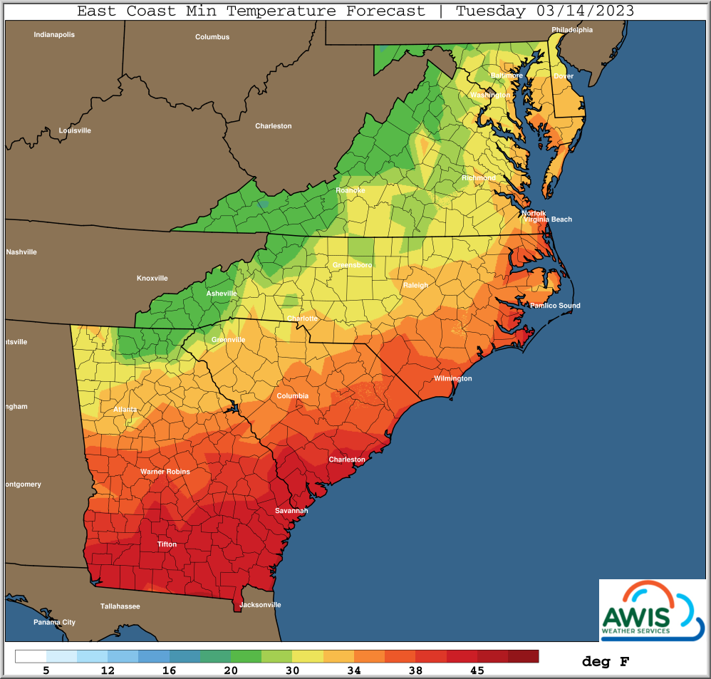
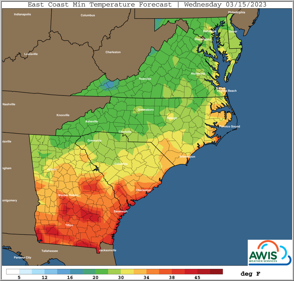
*** Coldest Morning, Highest Frost Risk, Ground Freeze Wed AM 03/15
What is called a fast “zonal” flow of storms from West Coast
to East Coast will be the highlight in the next couple weeks.
This will bring in multiple chances for rain, with brief warming
ahead of the rain, and then a couple colder days/mornings behind
each event.
These events will be about 3-4 days or so apart as an average,
but could be slightly less at times.
There could be snow at times on the Northern fringes of these
systems, at least before the precipitation ends.
In most cases the first coldest morning will have at least some
wind, with the coldest morning generally the second morning,
with winds lighter and added frost risk some areas.
At this time coldest minimums will generally be in the middle 20s
ranges, mainly Northern areas, but there will be pockets of slightly
colder minimums, particularly on lighter winds nights.
Growers are also advised that on the lighter wind mornings, temperatures
typically closer to crop and ground levels can be 3-6 degrees colder
than those officially forecast for and measured at the 5 foot levels,
along with added frost risks, particularly where dew points are projected
to be in the middle 20s or higher ranges.
Growers are advised to keep updated on daily forecasts for timing
of these events for their local area, and the type of cold event
and timing of, behind each one of these systems. Daily adjustments to
extent of cold and/or timing is likely, particularly if more than
a couple days out into the forecast future.
It will be critical to follow advice from local consultants on
proper management decisions, which will likely vary by location
based on anticipated weather, and crop status.
—————————————————————
A Quick Summary Of Weather Highlights Below:
Highest Precipitation Chance Periods, Mostly Rain:
————————————————–
Friday 03/10 Mostly 1/2 Inch, Higher Mainly Southern Areas
Sunday 03/12 Mostly 1/2 – Locally 1 Inch
Friday-Saturday 03/17-18 – Mostly 1/2 Inch Or Less
Mornings With Some Freeze Potential, But Also With Some Winds/Lower Frost Risks
——————————————————————————-
Breezy At Times Saturday Morning 03/11, Mainly Eastern Carolinas Northward
Breezy At Times Late Monday Night – Early Tuesday Evening 03/[13 14]
Breezy At Times Late Saturday Night – Early Sunday Evening 03/[18 19]
Highest Frost Risk Mornings, With Colder Ground Temperatures
————————————————————
Sunday Morning 03/12/2023
Mainly Northern NC / Northward
Wednesday Morning 03/15/2023
Mainly Northern SC / Northward (Highest Freeze Threat This Day)
Perhaps Some Lingering Light Winds Extreme Eastern NC
Sunday and/or Monday Morning 03/[19 20]/2023
Perhaps Higher Freeze/Frost Risk Further South
Min Temperature Prediction Maps
Fig 1: Predicted Min. Temperatures for the Region for Tuesday (3/14) and Wednesday (3/15)


