


Saturday Evening Frost Update From AWIS (6:53pm, March 17, 2018)
go.ncsu.edu/readext?516564
en Español / em Português
El inglés es el idioma de control de esta página. En la medida en que haya algún conflicto entre la traducción al inglés y la traducción, el inglés prevalece.
Al hacer clic en el enlace de traducción se activa un servicio de traducción gratuito para convertir la página al español. Al igual que con cualquier traducción por Internet, la conversión no es sensible al contexto y puede que no traduzca el texto en su significado original. NC State Extension no garantiza la exactitud del texto traducido. Por favor, tenga en cuenta que algunas aplicaciones y/o servicios pueden no funcionar como se espera cuando se traducen.
Português
Inglês é o idioma de controle desta página. Na medida que haja algum conflito entre o texto original em Inglês e a tradução, o Inglês prevalece.
Ao clicar no link de tradução, um serviço gratuito de tradução será ativado para converter a página para o Português. Como em qualquer tradução pela internet, a conversão não é sensivel ao contexto e pode não ocorrer a tradução para o significado orginal. O serviço de Extensão da Carolina do Norte (NC State Extension) não garante a exatidão do texto traduzido. Por favor, observe que algumas funções ou serviços podem não funcionar como esperado após a tradução.
English
English is the controlling language of this page. To the extent there is any conflict between the English text and the translation, English controls.
Clicking on the translation link activates a free translation service to convert the page to Spanish. As with any Internet translation, the conversion is not context-sensitive and may not translate the text to its original meaning. NC State Extension does not guarantee the accuracy of the translated text. Please note that some applications and/or services may not function as expected when translated.
Collapse ▲Good evening,
There was a serious frost this morning in many areas of the state that “just sort of snuck up on us,” as John Gross (Sanford) said to me this morning. Growers who removed row covers yesterday morning (Friday) to get the crop “opened up” for pollination purposes — had to run sprinkler irrigation systems this morning. Up here in Williamsburg, VA (where I live), we had a tremendous frost this morning (got to 26 F).
NC Risk for Frost on Sunday morning??
It does not appear that there is any great frost risk for Sunday morning across the state, but in some areas where you see those powder blue (38-40) and teal bands (36-38), I might be inclined to do a“a little wandering around in the field in the early morning to see what is really going on (Scot Luton, Roper, NC).”
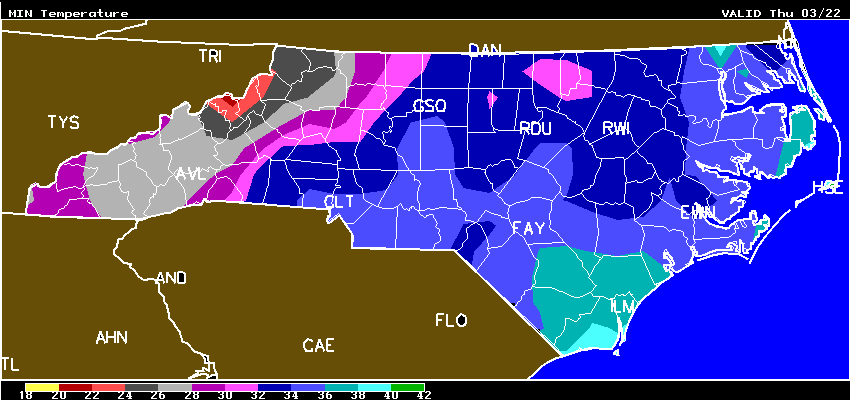
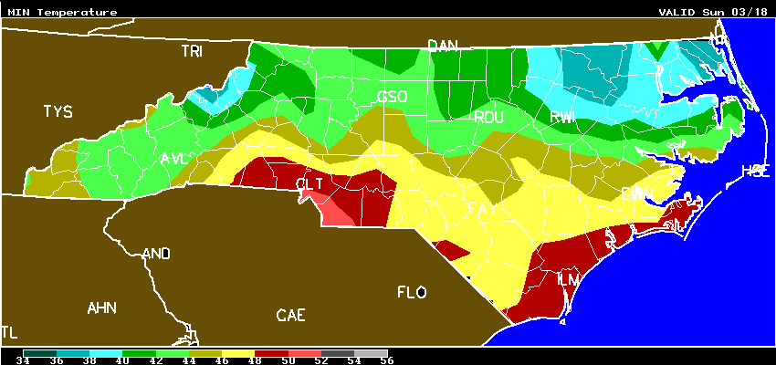 Fig. 1. Minimum temperatures for NC on Sunday morning
In examining some locations in the “Inner Banks” region of NC, like Ahoskie, Ahoskie Sunday morning you can see the minimum is expected to be 38 with OVC skies (overcast), but if skies were to clear in the early morning, and winds drop just a little bit, guess what might happen in some of those “cold pockets”?
Sunday night/Monday morning
Looking ahead to Sunday night/Monday morning, the probability of frost is much greater in Ahoskie/Edenton areas as skies will be clear, and winds in 0-1 mph range. With a dew point of 32 F on Monday morning these are near about perfect radiation frost conditions.
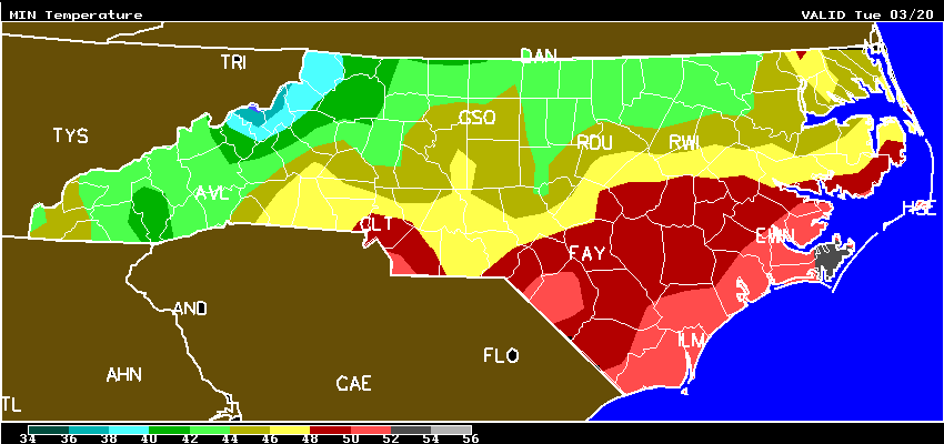
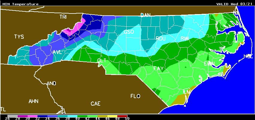
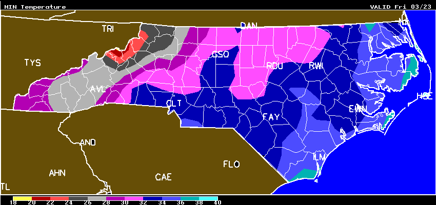
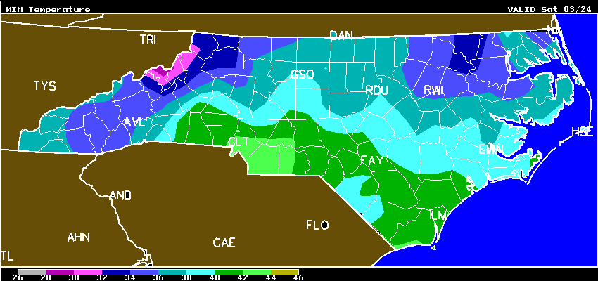
Every area of the state is different, and you will want to do some advance FROST planning for what is ahead in your area this week. And, please note that there is going to be risk of frost right into next Friday morning. Here are the minimum temperature state maps for Monday – Saturday, and FRIDAY MORNING is looking like the coldest morning of the week.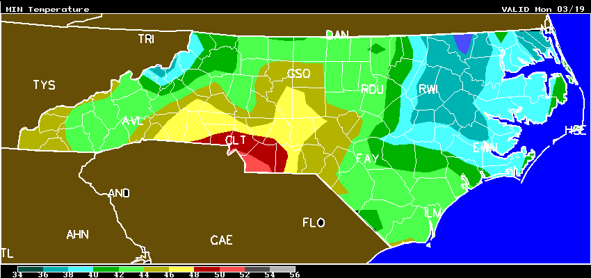
How is the crop advancing in different areas?
Up here in VA where I now live, we have a very cold week on tap this week, and we are still a good ways off from the start of the season. However, I received these 2 photos of Merced today from a southeastern NC grower!
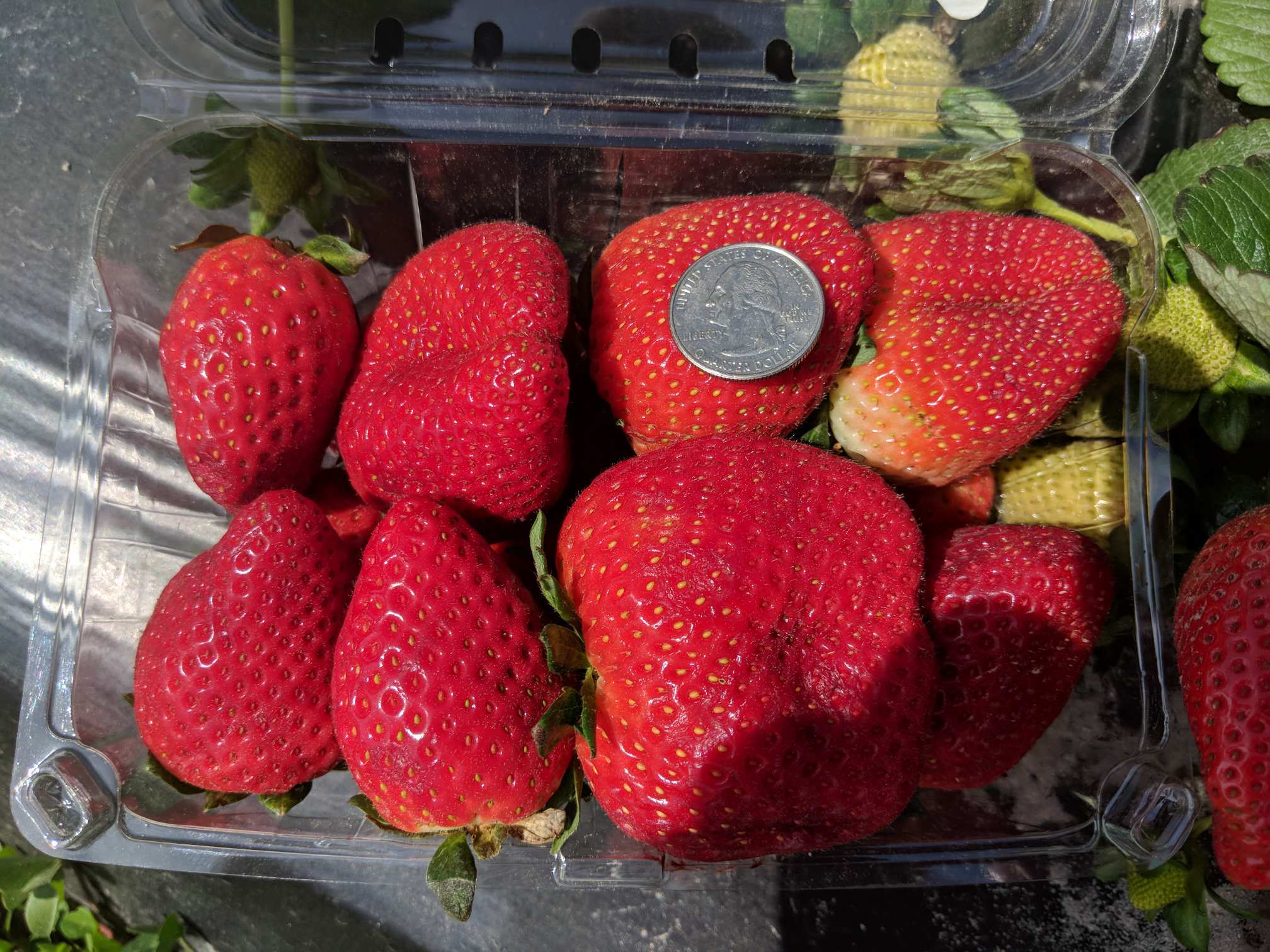
 Figs. 2 and 3. This is Merced in Southeastern NC (near Wilmington) on March 17th
And, I asked Clyde Gurosik, N. Augusta, SC, if he could share with us his season starting dates for the last 5 years (last year was super early). His goal is to be open 3/23 this year.
Dr. Poling,
Here is the data requested:
3/23/18 GOAL
3/18/17 all 6 markets, some by 3/1/17
4/2/16
4/11/15
4/7/14
4/3/13
3/31/12
Bet if I go to the history files, available thru www.weather.uga.edu, there will be some correlations.
Clyde
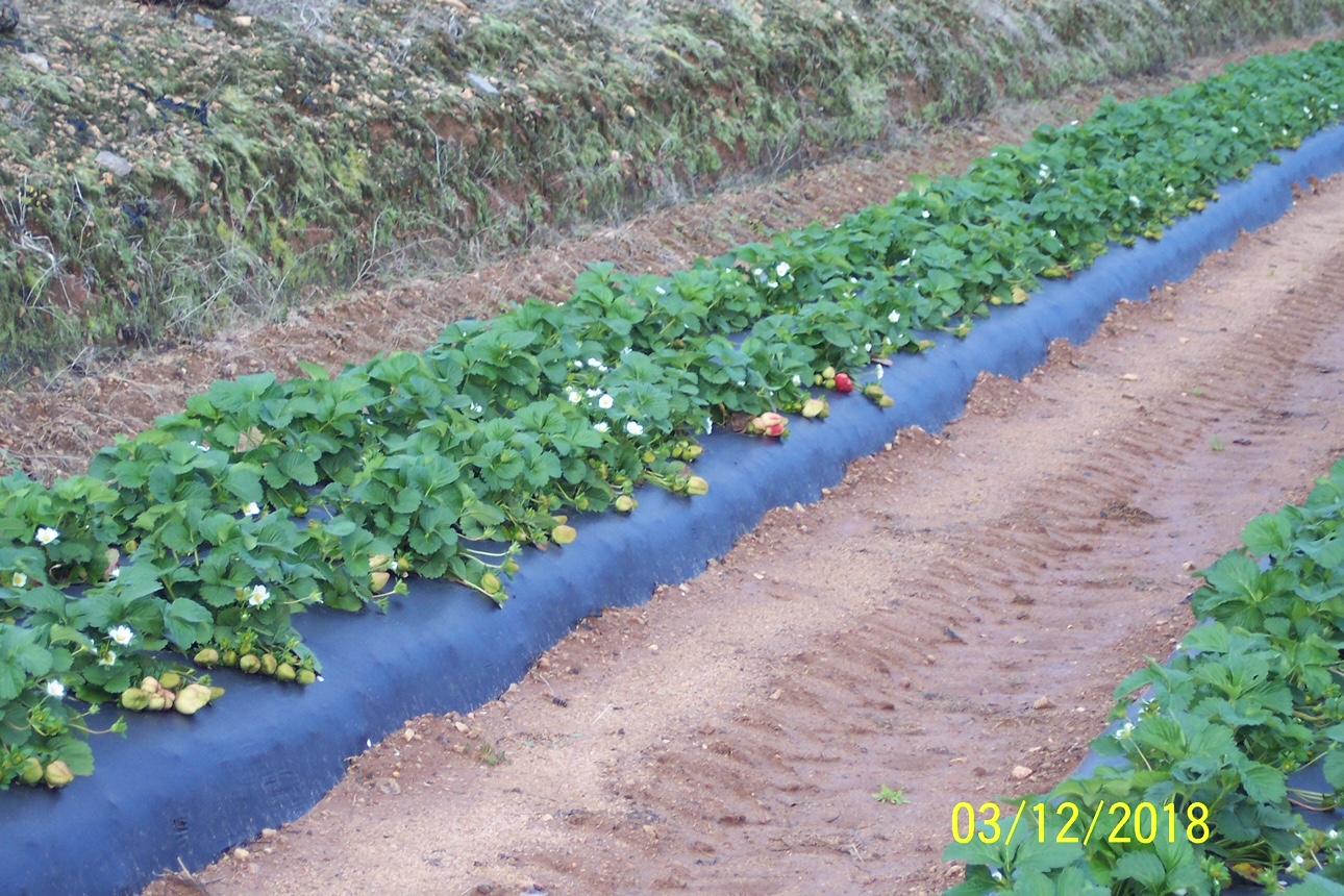 Fig. 4. Camarosa on 3/12 in N. Augusta, SC.
North Carolina
10-DAY DETAILED HOURLY WEATHER FORECASTS FOR NC
AWIS Weather Services, Inc. North Carolina Frost/Freeze Forecast
Produced at  505 p.m. CDT on Sat Mar 17 2018

... Forecast for Tonight ... Northeast NC Coast
Currituck/Camden/Pasquotank/Tyrrell Counties
**** LITTLE IF ANY FROST DUE TO CLOUDS ****

Lowest Temperatures:      38 - 45
Elizabeth_City Min          38
Range Dewpoint Temps:     29 - 50
Range Wetbulb  Temps:     34 - 53
AVG Wind Direction/Speed:  NE  7
AVG Sky Condition:         Cloudy

Extended Forecast: Range of Lowest Min Temperatures in the Above Zones
Min Temps Valid For Morning of Given Date (May NOT include ALL cold pockets)

  03/19/18  03/20/18  03/21/18  03/22/18  03/23/18  03/24/18
  --------  --------  --------  --------  --------  --------
   37 - 44   44 - 50   39 - 45   34 - 40   35 - 41   37 - 43
--------

East Central/SE NC Coast
Carteret/Pamlico Counties

*** No Frost And/Or Freeze Danger Tonight ***

Lowest Temperatures:      47 - 50
Morehead_City Min           49

Extended Forecast: Range of Lowest Min Temperatures in the Above Zones
Min Temps Valid For Morning of Given Date (May NOT include ALL cold pockets)

  03/19/18  03/20/18  03/21/18  03/22/18  03/23/18  03/24/18
  --------  --------  --------  --------  --------  --------
   38 - 42   51 - 52   39 - 44   31 - 36   33 - 36   38 - 41
--------

Southeast NC
NWS FORECAST ZONES 87-90,96-101

*** No Frost And/Or Freeze Danger Tonight ***

Lowest Temperatures:      45 - 53
Elizabethtown Min           48

Extended Forecast: Range of Lowest Min Temperatures in the Above Zones
Min Temps Valid For Morning of Given Date (May NOT include ALL cold pockets)

  03/19/18  03/20/18  03/21/18  03/22/18  03/23/18  03/24/18
  --------  --------  --------  --------  --------  --------
   40 - 48   49 - 54   39 - 46   32 - 36   30 - 34   35 - 41
--------

North-Central NC
Franklin County Area
**** LITTLE IF ANY FROST DUE TO CLOUDS ****

Lowest Temperatures:      39 - 47
Louisburg Min               39
Range Dewpoint Temps:     35 - 47
Range Wetbulb  Temps:     38 - 49
AVG Wind Direction/Speed:  NE  6     Periods of Calm
AVG Sky Condition:         Cloudy

Extended Forecast: Range of Lowest Min Temperatures in the Above Zones
Min Temps Valid For Morning of Given Date (May NOT include ALL cold pockets)

  03/19/18  03/20/18  03/21/18  03/22/18  03/23/18  03/24/18
  --------  --------  --------  --------  --------  --------
   37 - 47   38 - 48   31 - 40   28 - 35   27 - 34   29 - 37
--------

North/Central NC
Alamance County Area

*** No Frost And/Or Freeze Danger Tonight ***

Lowest Temperatures:      41 - 47
Graham_AG Min               43

Extended Forecast: Range of Lowest Min Temperatures in the Above Zones
Min Temps Valid For Morning of Given Date (May NOT include ALL cold pockets)

  03/19/18  03/20/18  03/21/18  03/22/18  03/23/18  03/24/18
  --------  --------  --------  --------  --------  --------
   42 - 47   41 - 46   33 - 38   30 - 35   29 - 34   31 - 37
--------

South/Central NC
Richmond County Area

*** No Frost And/Or Freeze Danger Tonight ***

Lowest Temperatures:      45 - 49
Ellerbe Min                 47

Extended Forecast: Range of Lowest Min Temperatures in the Above Zones
Min Temps Valid For Morning of Given Date (May NOT include ALL cold pockets)

  03/19/18  03/20/18  03/21/18  03/22/18  03/23/18  03/24/18
  --------  --------  --------  --------  --------  --------
   40 - 48   45 - 51   39 - 41   32 - 34   30 - 33   34 - 38
--------

Interior/EC-SE NC
Wayne County Area

*** No Frost And/Or Freeze Danger Tonight ***

Lowest Temperatures:      44 - 50
Goldsboro_AG Min            46

Extended Forecast: Range of Lowest Min Temperatures in the Above Zones
Min Temps Valid For Morning of Given Date (May NOT include ALL cold pockets)

  03/19/18  03/20/18  03/21/18  03/22/18  03/23/18  03/24/18
  --------  --------  --------  --------  --------  --------
   37 - 42   47 - 51   39 - 42   31 - 34   30 - 35   35 - 38
--------

For more detailed information visit www.awis.com or call 888-798-9955. Copyright 2018 AWIS Weather Services, Inc. All rights reserved.
Virginia
10-DAY DETAILED HOURLY WEATHER FORECASTS
Maryland
10-DAY DETAILED HOURLY WEATHER FORECASTS
South Carolina
10-DAY DETAILED HOURLY WEATHER FORECASTS
Georgia
10-DAY DETAILED HOURLY WEATHER FORECASTS
Kentucky
10-DAY DETAILED HOURLY WEATHER FORECASTS