


Increased Risk of Freeze / Frost Apr 8-10
go.ncsu.edu/readext?1066448
en Español / em Português
El inglés es el idioma de control de esta página. En la medida en que haya algún conflicto entre la traducción al inglés y la traducción, el inglés prevalece.
Al hacer clic en el enlace de traducción se activa un servicio de traducción gratuito para convertir la página al español. Al igual que con cualquier traducción por Internet, la conversión no es sensible al contexto y puede que no traduzca el texto en su significado original. NC State Extension no garantiza la exactitud del texto traducido. Por favor, tenga en cuenta que algunas aplicaciones y/o servicios pueden no funcionar como se espera cuando se traducen.
Português
Inglês é o idioma de controle desta página. Na medida que haja algum conflito entre o texto original em Inglês e a tradução, o Inglês prevalece.
Ao clicar no link de tradução, um serviço gratuito de tradução será ativado para converter a página para o Português. Como em qualquer tradução pela internet, a conversão não é sensivel ao contexto e pode não ocorrer a tradução para o significado orginal. O serviço de Extensão da Carolina do Norte (NC State Extension) não garante a exatidão do texto traduzido. Por favor, observe que algumas funções ou serviços podem não funcionar como esperado após a tradução.
English
English is the controlling language of this page. To the extent there is any conflict between the English text and the translation, English controls.
Clicking on the translation link activates a free translation service to convert the page to Spanish. As with any Internet translation, the conversion is not context-sensitive and may not translate the text to its original meaning. NC State Extension does not guarantee the accuracy of the translated text. Please note that some applications and/or services may not function as expected when translated.
Collapse ▲Increased Risk of Frost Apr 8-10
In collaboration with AWIS Weather Services
*** Widespread Frost/Freeze Event Next 1-3 Days
*** Shower Chances Return Late Week
*** Perhaps Lesser Freeze Threat this Weekend
Dear all,
While colder weather has post-poned strawberry season for a few days, the most recent weather challenge was the extreme Warmth for many areas last week that pushed strawberries into more advanced stages. Strawberry season officially began!
However, with that, we are also entering the stages of increased cold threats here in the Southeast. The challenge knocking on our doors this week will be a turn to much colder temperatures, spilling in from Canada, deep into the Eastern USA through the middle of this week.
The freeze/frost threat begins tonight for areas along and West of the Appalachian Chain, with a significant frost/ground freeze in some areas.
This frost and/or ground freeze threat spreads Eastward to areas along and East of the Appalachian chain for Wednesday morning, and as far South as Northern areas of Alabama and Georgia.
Most of NC will be under a frost warning the night from Tuesday to Wednesday.
Row-covers and/or sprinklers where winds are lower are recommended to save open blossoms! Remember, open blossoms are your most vulnerable stage on a strawberry plant. The weather conditions predicted for the coming days in NC have the potential to cause damage on open blossoms, if not protected.
Futher predictions:
There may be still a lingering frost threat for the far Northern and Eastern areas into Thursday morning, but most areas warm to above frost/freeze risks.
After that, more showers and storms, but of much lesser intensity than the past round of storms, will move across the Eastern USA late this week ahead of the next cold front.
The air mass behind this is not as cold, but still has potential to deal yet another round of frost threat, mainly to Northern areas, with an outside shot of light ground freeze as well.
Behind that the freeze/frost risks will dwindle some as we get into the latter part of April and into May.
However, there are some trends emerging for above normal rainfall from Mid April To Early May, that would further challenge growers to keep an active spray program going to help control plant disease issues.
The upcoming few weeks still are critical as we get deeper into the harvesting season, and there remains potential for late season cold snaps, particularly for Northern areas.
Keep alert to daily weather forecasts and anticipated upcoming weather trends, as minor weather pattern changes can yield significant weather impacts affecting daily operational decision making.
Local weather and crop consultants should be contacted where possible to help make the best possible decisions in limiting growers risks, while hoping to make a decent profit along the way!
Forecast maps for the region:
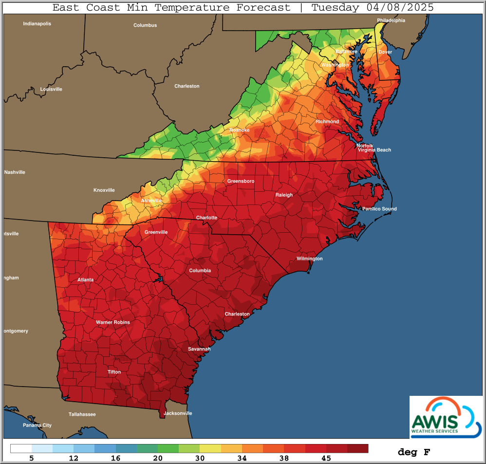
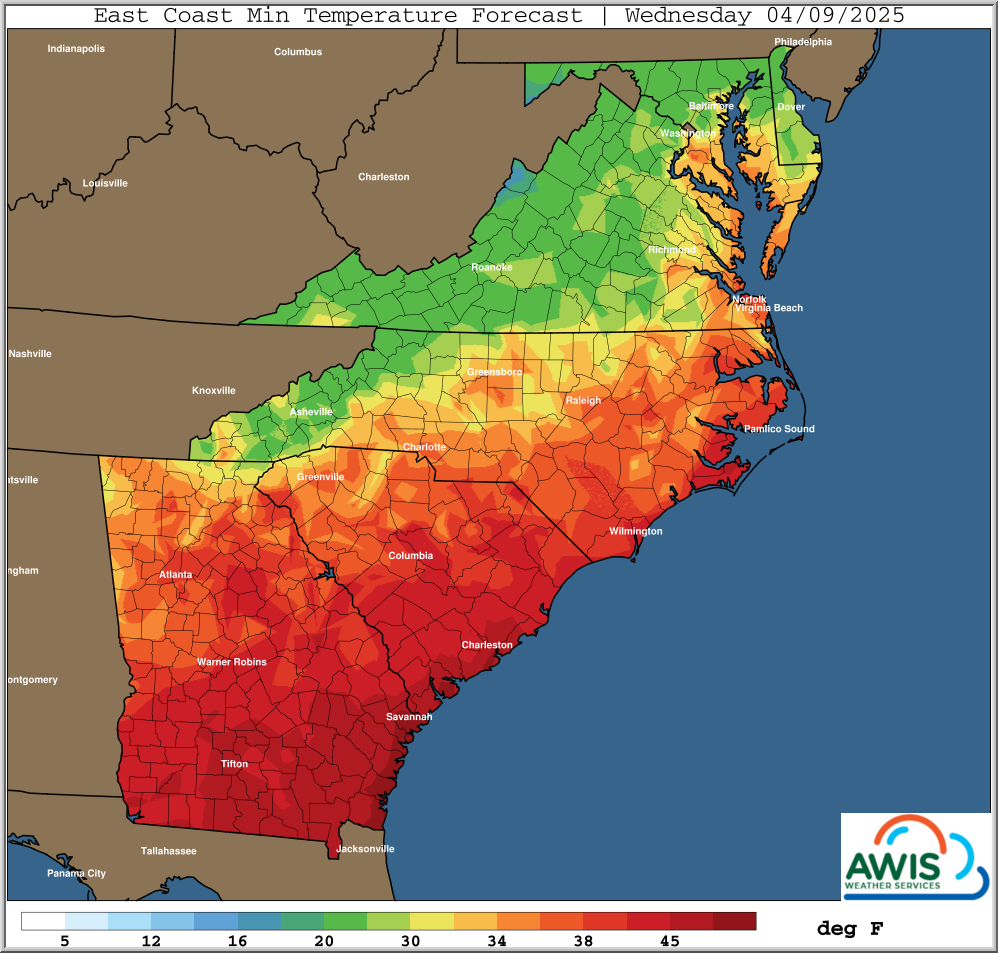
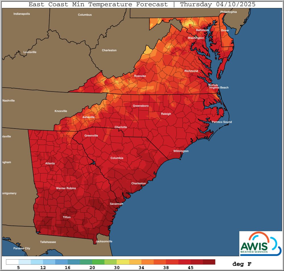
Figure 1: Minimum Temperature preduction for the coming days.