


AWIS Weather Advisory: POTENTIAL FREEZE Late This Weekend, Into Monday.
go.ncsu.edu/readext?1057542
en Español / em Português
El inglés es el idioma de control de esta página. En la medida en que haya algún conflicto entre la traducción al inglés y la traducción, el inglés prevalece.
Al hacer clic en el enlace de traducción se activa un servicio de traducción gratuito para convertir la página al español. Al igual que con cualquier traducción por Internet, la conversión no es sensible al contexto y puede que no traduzca el texto en su significado original. NC State Extension no garantiza la exactitud del texto traducido. Por favor, tenga en cuenta que algunas aplicaciones y/o servicios pueden no funcionar como se espera cuando se traducen.
Português
Inglês é o idioma de controle desta página. Na medida que haja algum conflito entre o texto original em Inglês e a tradução, o Inglês prevalece.
Ao clicar no link de tradução, um serviço gratuito de tradução será ativado para converter a página para o Português. Como em qualquer tradução pela internet, a conversão não é sensivel ao contexto e pode não ocorrer a tradução para o significado orginal. O serviço de Extensão da Carolina do Norte (NC State Extension) não garante a exatidão do texto traduzido. Por favor, observe que algumas funções ou serviços podem não funcionar como esperado após a tradução.
English
English is the controlling language of this page. To the extent there is any conflict between the English text and the translation, English controls.
Clicking on the translation link activates a free translation service to convert the page to Spanish. As with any Internet translation, the conversion is not context-sensitive and may not translate the text to its original meaning. NC State Extension does not guarantee the accuracy of the translated text. Please note that some applications and/or services may not function as expected when translated.
Collapse ▲POTENTIAL FREEZE late this weekend.
In collaboration with AWIS Weather Service
Welcome back to the most challenging time of the year. The warm weather this week, together with plenty to accumulated chilling hours over the past month, most likely has pushed many of your plants this week.
Some of you in Eastern NC might have started fertilizing already, hoping for an early April begin of season. Well – the weather might have different plans, because we are expecting winds, rain and cold air moving in from up North into mid Atlantic and the Southeastern shore.
We are expecting at the moment minimum temperatures in the low 20s for Monday (3/3/2025) morning in most of North Carolina.
Critical temperatures to protect flowers, depending on the stage of development:
- Tight bud: 22.0
- Popcorn: 26.5
- Open blossom: 30.0
- Fruit: 28.0
If you see flowers on your plants, especially in the popcorn or even open blossom stage, and your intention is to keep the blossoms alive, protection is key. The predicted weather pattern will probably not allow for much overhead sprinklers (depending on the local wind activity), and allow for only limited time to use row covers after the rain. Row covers will need to be well secured (wind), otherwise they can cause damage as well. This might be also still early enough for you in the season for you to make a judgement call and let flowers freeze off.
Either way, stay alert and we will keep you updated as this event will come closer over the weekend.
General Weather Discussion
*** Quick Update For Colder Air Late This Weekend
*** Hard Freeze Potential, Mainly Monday Morning
*** Warmer Middle Half Next Week
*** Increased Rain Threat Middle-End Next Week
*** Potentially Colder Again Late Next Week, Next Weekend
As is typical this time of year, minor changes in the upper air pattern can yield enough
changes in local temperatures to be aware of.
Such is the case as a clipper-like system will move through the Great Lakes and into the Northeast Friday and Saturday with another quick shot of polar/arctic air behind it. This will allow another surge of cold air from Canada to dig Southeast, with another hard freeze potential by early next week, with minimums 20-25 ranges.
After that a warmup and increasing shower chances later next week, followed by
another cool down behind that towards the following weekend. Given the dynamic
weather pattern ahead, please stay alert to daily updates for potential changes that may impact critical management decisions.
Minimum Temperature Predictions
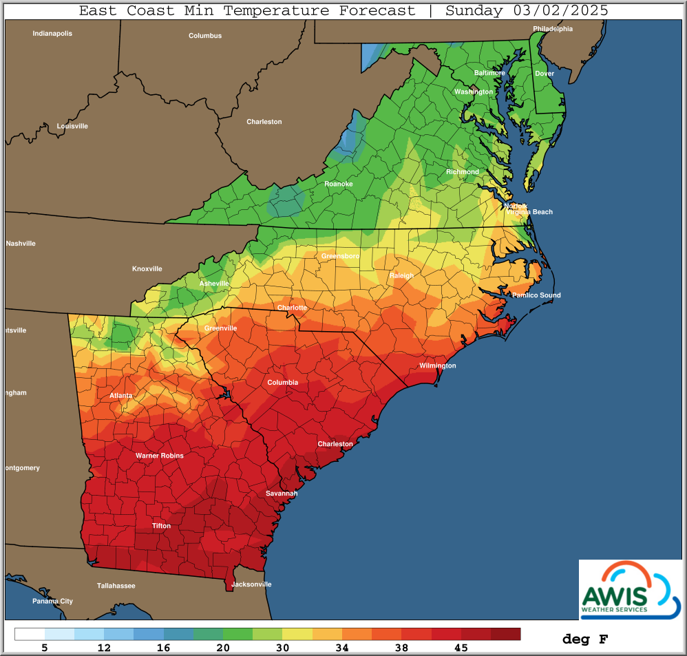
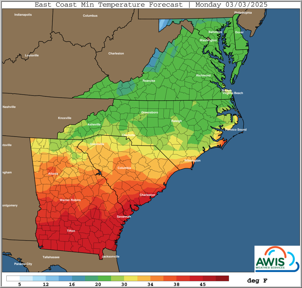
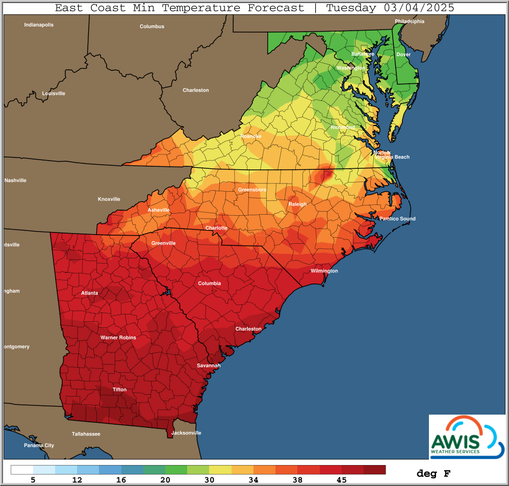
Figure 1: Predicted minimum Temperatures for Sunday, Monday and Tuesday (3/2/2025 – 3/4/2025).