AWIS Weather Advisory: Polar Vortex Affects North Carolina
go.ncsu.edu/readext?1049158
en Español / em Português
El inglés es el idioma de control de esta página. En la medida en que haya algún conflicto entre la traducción al inglés y la traducción, el inglés prevalece.
Al hacer clic en el enlace de traducción se activa un servicio de traducción gratuito para convertir la página al español. Al igual que con cualquier traducción por Internet, la conversión no es sensible al contexto y puede que no traduzca el texto en su significado original. NC State Extension no garantiza la exactitud del texto traducido. Por favor, tenga en cuenta que algunas aplicaciones y/o servicios pueden no funcionar como se espera cuando se traducen.
Português
Inglês é o idioma de controle desta página. Na medida que haja algum conflito entre o texto original em Inglês e a tradução, o Inglês prevalece.
Ao clicar no link de tradução, um serviço gratuito de tradução será ativado para converter a página para o Português. Como em qualquer tradução pela internet, a conversão não é sensivel ao contexto e pode não ocorrer a tradução para o significado orginal. O serviço de Extensão da Carolina do Norte (NC State Extension) não garante a exatidão do texto traduzido. Por favor, observe que algumas funções ou serviços podem não funcionar como esperado após a tradução.
English
English is the controlling language of this page. To the extent there is any conflict between the English text and the translation, English controls.
Clicking on the translation link activates a free translation service to convert the page to Spanish. As with any Internet translation, the conversion is not context-sensitive and may not translate the text to its original meaning. NC State Extension does not guarantee the accuracy of the translated text. Please note that some applications and/or services may not function as expected when translated.
Collapse ▲Polar Vortex affects North Carolina
In collaboration with AWIS Weather Services
Dear all,
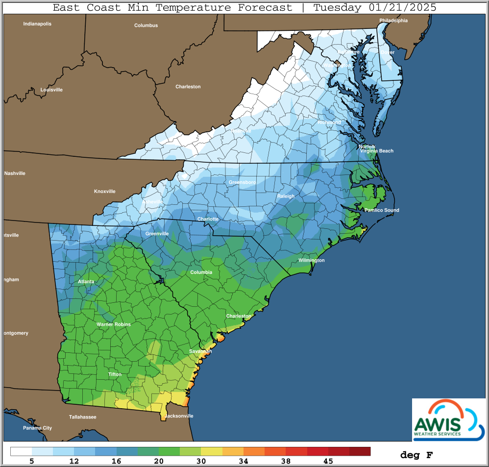
The coming days will bring cold air into North Carolina, starting this night. Air temperatures will drop in most of North Carolina into the teens, and in some parts even lower than that, starting the night from today (Monday) to Tuesday, 01/21/2025.
This is not as bad as it sounds, because the region showed relatively stable cold weather in the past weeks. Which means that your strawberry plants should be dormant, and adapted to colder temperatures at this point of time.
However, especially in areas in which minimum temperatures are predicted to cross into the single digits, extra precautions might be necessary.
For all of NC:
Using row covers to avoid damage will be enough in most regions of North Carolina.
Foothills, Western NC, Triad and other affected regions:
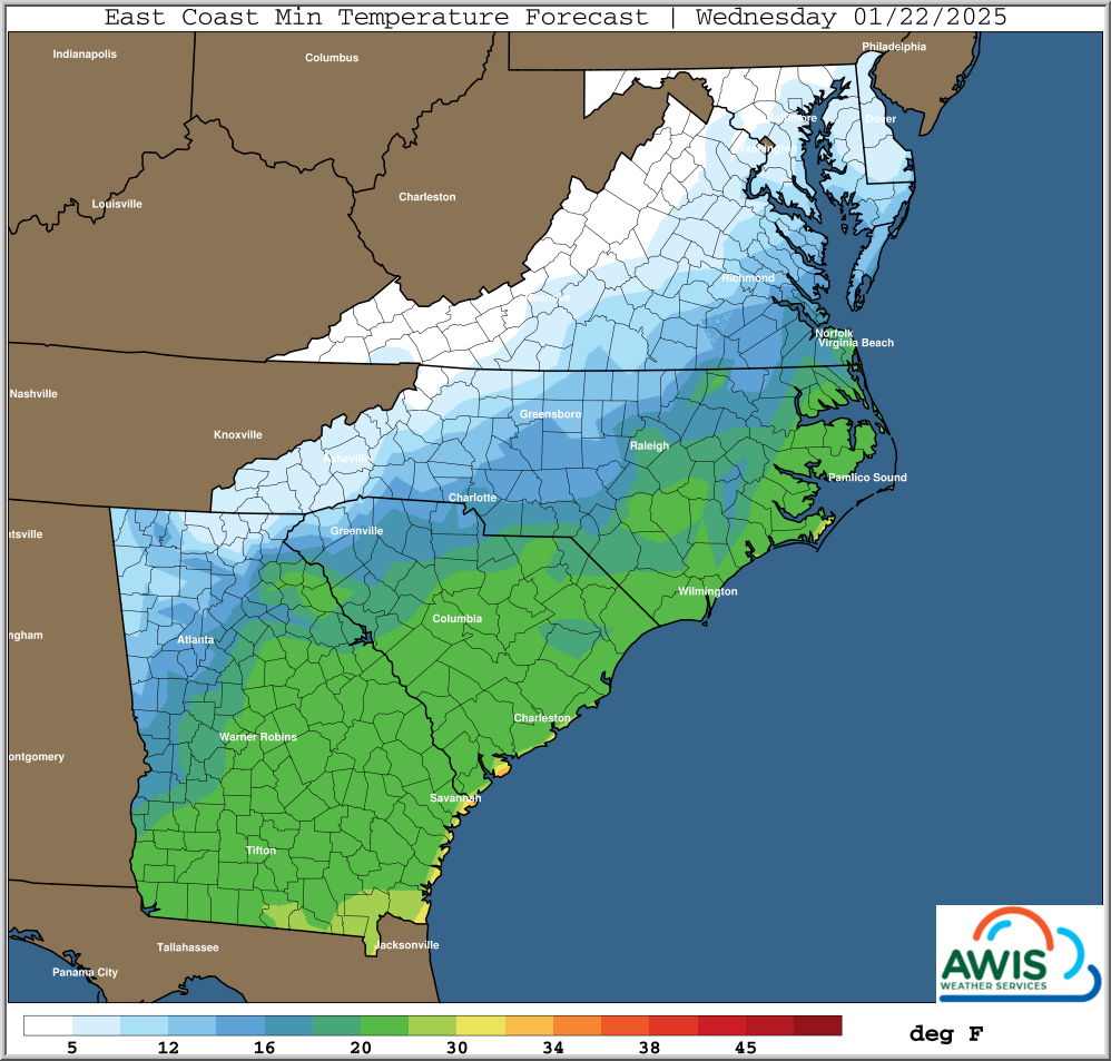
Some regions in NC will see lowest minimum temperatures predicted in the single digits, especially Monday-Tuesday, and Tuesday- Wednesday night. In those areas I recommend to monitor temperature under the row covers closely and have a second row cover available if needed.
General Forecast Discussion:
For Mid-Atlantic And Most SE States … Updated Friday 01/17/2024 (Karl Harker, AWIS Weather Service)
*** Next Arctic Surge this Week
*** Likely Coldest So Far This Winter Many Areas
*** Potential Snow Inland Mid-Atlantic Northward Ahead Of Arctic Surge
*** Potential Wintry Weather Southern Areas Next Week, Tuesday-Wednesday
*** Trending Towards Warmer/Wetter At Times Periods End Of January
Expect this to rival recent colds and in most cases be a little colder than what has already been experienced this winter season. This means minimums into the single digits if not lower Northern regions with snow cover, with teens well South deep into Georgia and Alabama. This arctic air mass will impact much of the Eastern Half of the USA from later this weekend through the middle part of next week, into Thursday morning Eastern areas. There will be some critical wind chills with the onset of this turn to colder, but the low pressure area is not expected to strengthen too much, so overly severe wind issues are not anticipated.
A more southern disturbance riding along the Northern Gulf Coast may spread snow and wintry precipitation in areas even further South than last week, perhaps as far South as Southern Alabama and Georgia and Coastal Carolinas, around next Tuesday into next Wednesday.
The recent surges of arctic air may at least temporarily end as we get closer to the end of January, with a turn to warmer and at times perhaps wet weather.
Please keep updated with local weather forecasts for your area for specific information and any potential changes that could impact decisions such as timing and usage of crop covers and other operational decisions..
Avoid Damage:
Most cultivars, if adapted to cold weather and dormant, will not show lethal crown damage at temperatures even as low as 10-15 F, depending on the cultivar. Plants that are not adapted, because they are either not well established, or heavily affected by disease or nutrition deficiencies, can show damage at even higher temperatures.
You have to keep in mind that these are temperatures that occur at plant level! When minim air temperatures (measured 2 m above the ground) are predicted in the 20-10 F range, then I usually ask growers for caution. Temperatures at the plant level could be a easily few degrees lower, depending on your location.
Extensive foliar freeze damage, even if not lethal, can set back a plant’s development. While a small amount of foliar damage is not a bid deal, extensive damage can be disastrous. That is especially important if the plants are smaller, affected by disease, or if there was a late planting. Foliar damage can occur at temperatures in the low 20s.
Row-Covers are the tool of choice:
In the best case scenario, you want to avoid both types of damage. With the predicted weather for the coming days, the chances are not too bad that you will. Winds will be calm for the most part, and there is only a slight chance of snow on Wednesday, and no other precipitation in the forecast.
Using row-covers is the tool of choice. Single row cover use should be protective in most areas in NC. Only in a few areas in NC, a second row cover MIGHT be needed. This depends on your local weather situation and how adapted the plants are to cold weather.
Minium Temperature Maps:
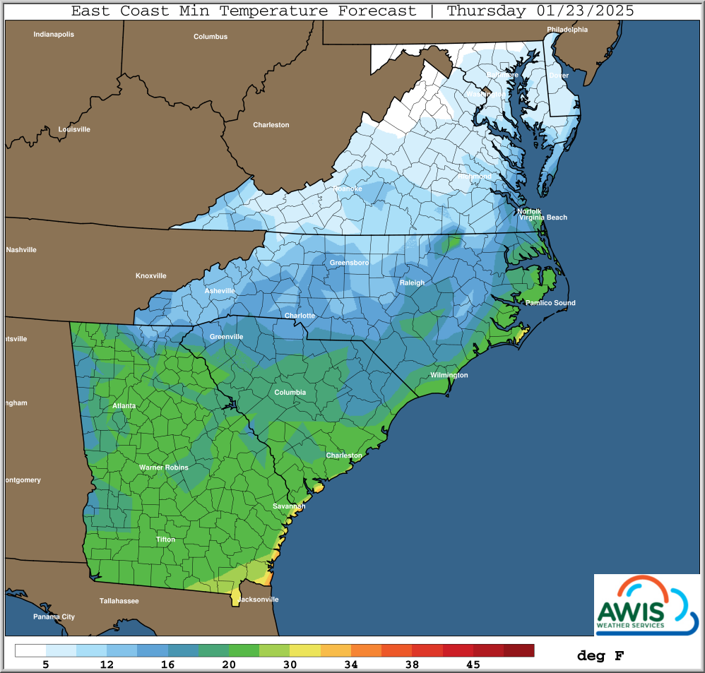
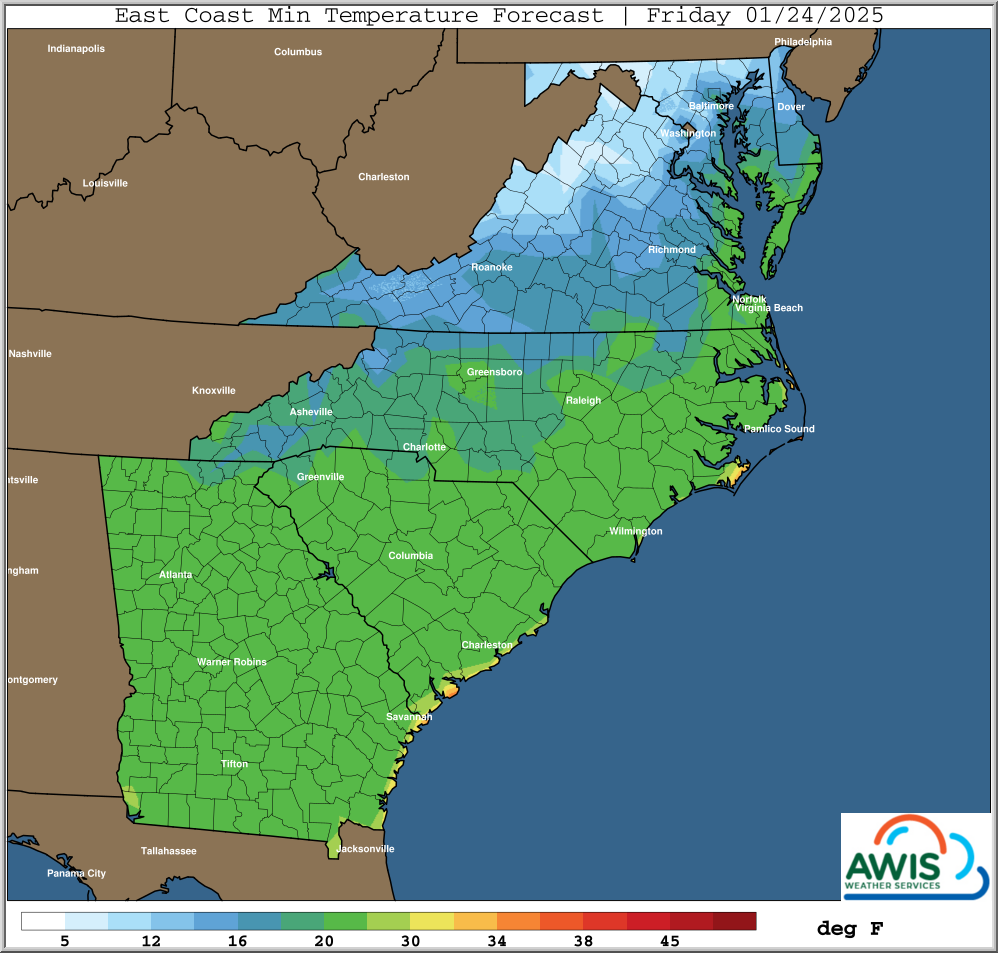
Figure 1: Predicted Minimum Temperatures for the region for Tuesday (01/21) to Friday (01/24).


