Frost/Freeze Advisory: Mid 20s Early Next Week.
go.ncsu.edu/readext?924629
en Español / em Português
El inglés es el idioma de control de esta página. En la medida en que haya algún conflicto entre la traducción al inglés y la traducción, el inglés prevalece.
Al hacer clic en el enlace de traducción se activa un servicio de traducción gratuito para convertir la página al español. Al igual que con cualquier traducción por Internet, la conversión no es sensible al contexto y puede que no traduzca el texto en su significado original. NC State Extension no garantiza la exactitud del texto traducido. Por favor, tenga en cuenta que algunas aplicaciones y/o servicios pueden no funcionar como se espera cuando se traducen.
Português
Inglês é o idioma de controle desta página. Na medida que haja algum conflito entre o texto original em Inglês e a tradução, o Inglês prevalece.
Ao clicar no link de tradução, um serviço gratuito de tradução será ativado para converter a página para o Português. Como em qualquer tradução pela internet, a conversão não é sensivel ao contexto e pode não ocorrer a tradução para o significado orginal. O serviço de Extensão da Carolina do Norte (NC State Extension) não garante a exatidão do texto traduzido. Por favor, observe que algumas funções ou serviços podem não funcionar como esperado após a tradução.
English
English is the controlling language of this page. To the extent there is any conflict between the English text and the translation, English controls.
Clicking on the translation link activates a free translation service to convert the page to Spanish. As with any Internet translation, the conversion is not context-sensitive and may not translate the text to its original meaning. NC State Extension does not guarantee the accuracy of the translated text. Please note that some applications and/or services may not function as expected when translated.
Collapse ▲More cold weather ahead
In collaboration with AWIS weather services
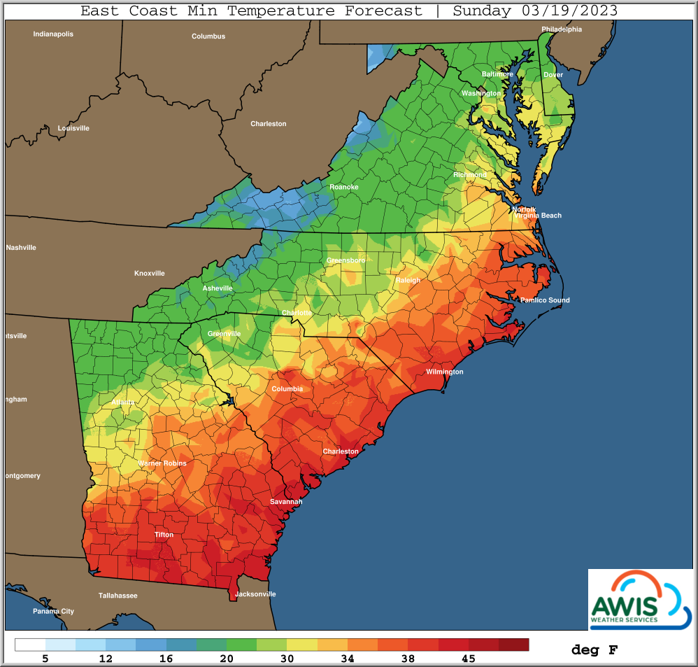
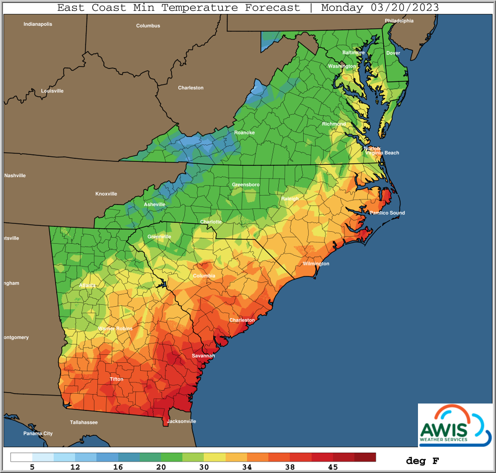
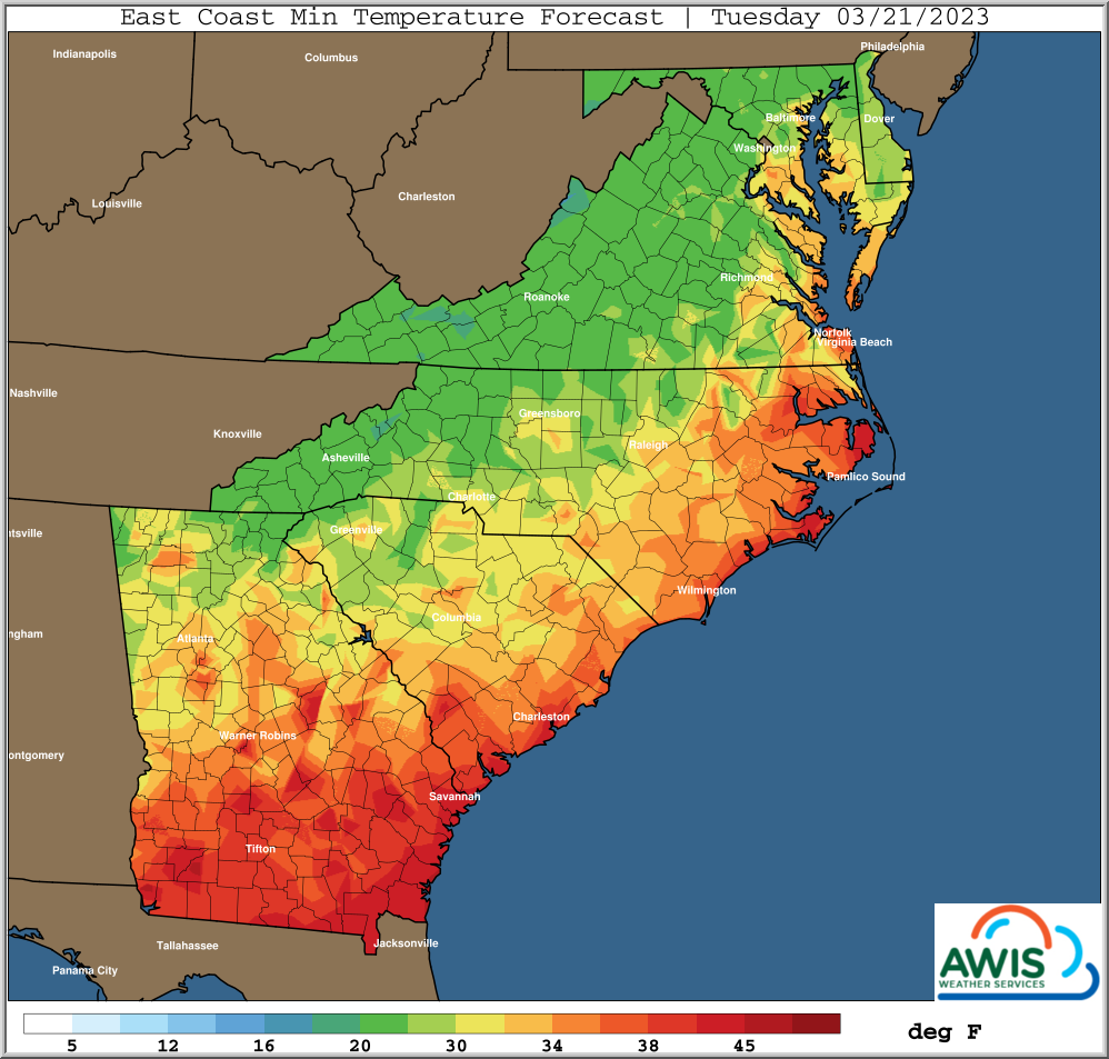
Dear all. The short period of warm weather will be over by tomorrow (Saturday, 3/18) night. We expect even colder temperatures and frost conditions, starting Sunday (3/19) morning and reaching to Wednesday (3/22).
For the most part, we will see low wind speeds (0-10 mph) and the forecast calls for clear nights with no cloud cover. These are perfect FROST conditions. The best advise is to use row-covers (1.2 oz or more). If you use overhead irrigation, please watch the dew-point. You will have to start overhead irrigation before dew-points reach critical values of 30-28. An hourly forecast for your region can be found in the tables below.
In some areas in Western NC, dew points will reach critical temperature in the mid to low 20s. Please consider double covering, ONLY if you have open blossoms on your crop that you want to save, AND you will experience those conditions.
Disease and Pests:
For prolonged row-cover use as we see it at the moment, certain diseases and pests can easily built up under covers. At the moment, those would be Bortytis grey mold and certain mite populations.
We highly recommend to spray before and certainly after removal or row covers. Please consult the Southeaster Strawberry IPM Guide for guidance.
We also recommend to evaluate you regional disease risks. Please use the NC Strawberry Risk Map and sign up for real-time updates on Anthracnose and Bortytis risk forecasts in your region.
General Discussion:
*** More Widespread Freezing Temperatures Late Weekend, First Half Next Week
*** Freeze, Limited Frost Threat Far Western Areas Saturday Morning
*** Increased Freeze Risk Particularly Western/Northern Areas Sunday Morning
*** Widespread Freeze Risk, Some Frost Risk Southern Areas, Monday Morning
*** Freeze, Increased Frost Risk Tuesday Morning, Particularly Northern Areas
*** Frost Risk Could Linger Northern/Eastern Areas Wednesday Morning
*** Warmer Last Half Next Week
*** Additional Cold Invasions Late March Look To Stay A Little Further North
The brief warm up late this week will be very short lived.
The next cold front is posed to pass through all areas later tonight and
Saturday morning.
Rain showers ahead of that mostly on the light side into early Saturday,
generally under 1/2 inch, but locally more with some isolated storms far
southern areas.
Then breezy and colder air moves in Saturday, with high pressure following the
same general path as the last cold event.
Main difference is that this cold event will have shorter durations of winds
as there is no East Coast storm. This may be particularly true in the more
Northern and Eastern areas where winds stayed up at times last cold event.
This potential of a couple days of lighter morning winds, means longer potential
duration of freezing temperatures.
This is a particularly dry air mass, with dew points even a little lower in many
areas than what occurred earlier this week.
Thus, this means increased risk of larger minimum temperature variations due
to these low dew point temperatures, related cold air drainage pockets, and
any areas more sheltered from any existing winds.
Also, growers can expect temperatures closer to crop and ground levels to be
3-5+ degrees colder than those experienced at the official 5ft observing and
forecast heights, particularly during lightest wind periods.
Coldest minimums likely as early as Sunday morning Western and some Northern
areas, with overall coldest temperatures likely Monday morning.
While the air mass will slowly moderate, there remains a freeze, and little
higher frost risk Tuesday morning, particularly from NE GA, and points Northward.
Can not rule out a threat of lingering frost far Northern areas even Wednesday
morning, but that may be in doubt with a forecast this far out in time.
In summary, there is potential for this freeze event to have minimums that could be
a little colder, with longer durations, than what occurred last event in some areas.
Frost risks are mostly low at the start with very low dew point temperatures.
Frost prospects increase towards the end of this freeze threat around next
Tuesday morning.


