AWIS Weather Advisory: Frost Days Ahead in Some Areas
go.ncsu.edu/readext?921274
en Español / em Português
El inglés es el idioma de control de esta página. En la medida en que haya algún conflicto entre la traducción al inglés y la traducción, el inglés prevalece.
Al hacer clic en el enlace de traducción se activa un servicio de traducción gratuito para convertir la página al español. Al igual que con cualquier traducción por Internet, la conversión no es sensible al contexto y puede que no traduzca el texto en su significado original. NC State Extension no garantiza la exactitud del texto traducido. Por favor, tenga en cuenta que algunas aplicaciones y/o servicios pueden no funcionar como se espera cuando se traducen.
Português
Inglês é o idioma de controle desta página. Na medida que haja algum conflito entre o texto original em Inglês e a tradução, o Inglês prevalece.
Ao clicar no link de tradução, um serviço gratuito de tradução será ativado para converter a página para o Português. Como em qualquer tradução pela internet, a conversão não é sensivel ao contexto e pode não ocorrer a tradução para o significado orginal. O serviço de Extensão da Carolina do Norte (NC State Extension) não garante a exatidão do texto traduzido. Por favor, observe que algumas funções ou serviços podem não funcionar como esperado após a tradução.
English
English is the controlling language of this page. To the extent there is any conflict between the English text and the translation, English controls.
Clicking on the translation link activates a free translation service to convert the page to Spanish. As with any Internet translation, the conversion is not context-sensitive and may not translate the text to its original meaning. NC State Extension does not guarantee the accuracy of the translated text. Please note that some applications and/or services may not function as expected when translated.
Collapse ▲AWIS Weather Advisory: Frost Days Ahead in some areas
In collaboration with AWIS Weather Services
Strawberry are early, and March is going to be interesting. Generally, if you are no at 10% bloom, I would not recommend to protect yet. But in some cases, especially with early cultivars, you might be already there.
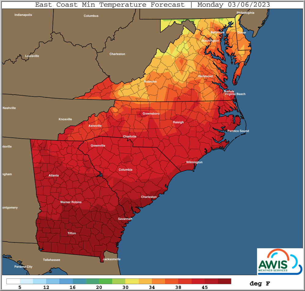
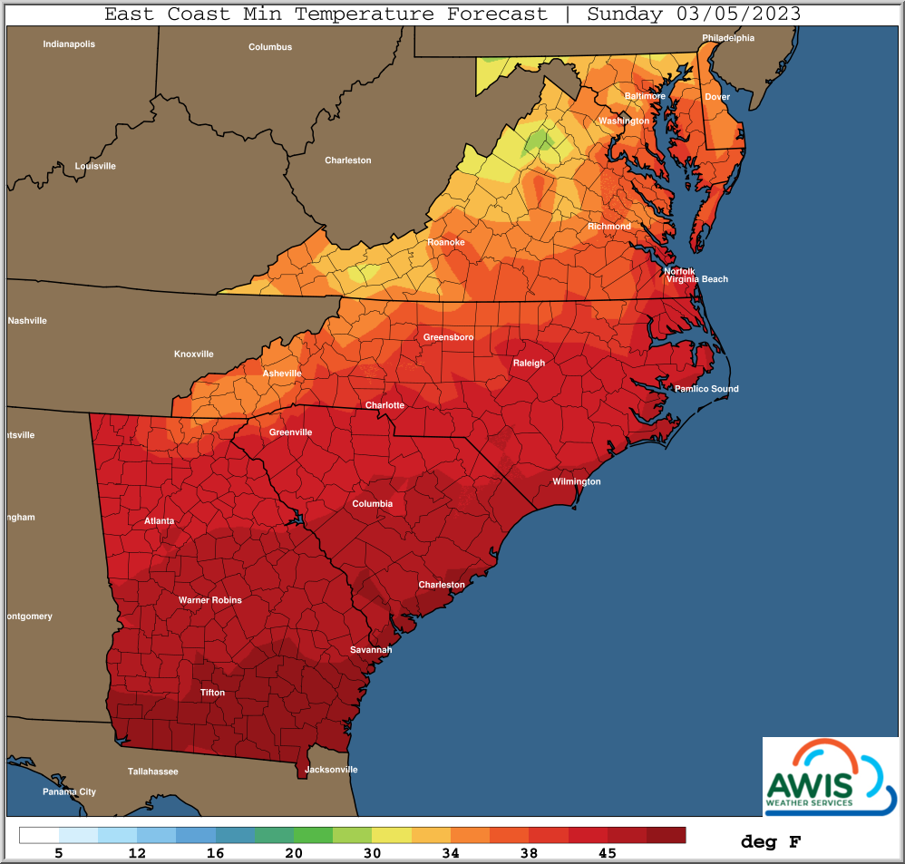
A slight chance for frost in Western NC and VA can occur this Sunday. Again, only if you have significant bloom, and you are in a risk area, you need to protect.
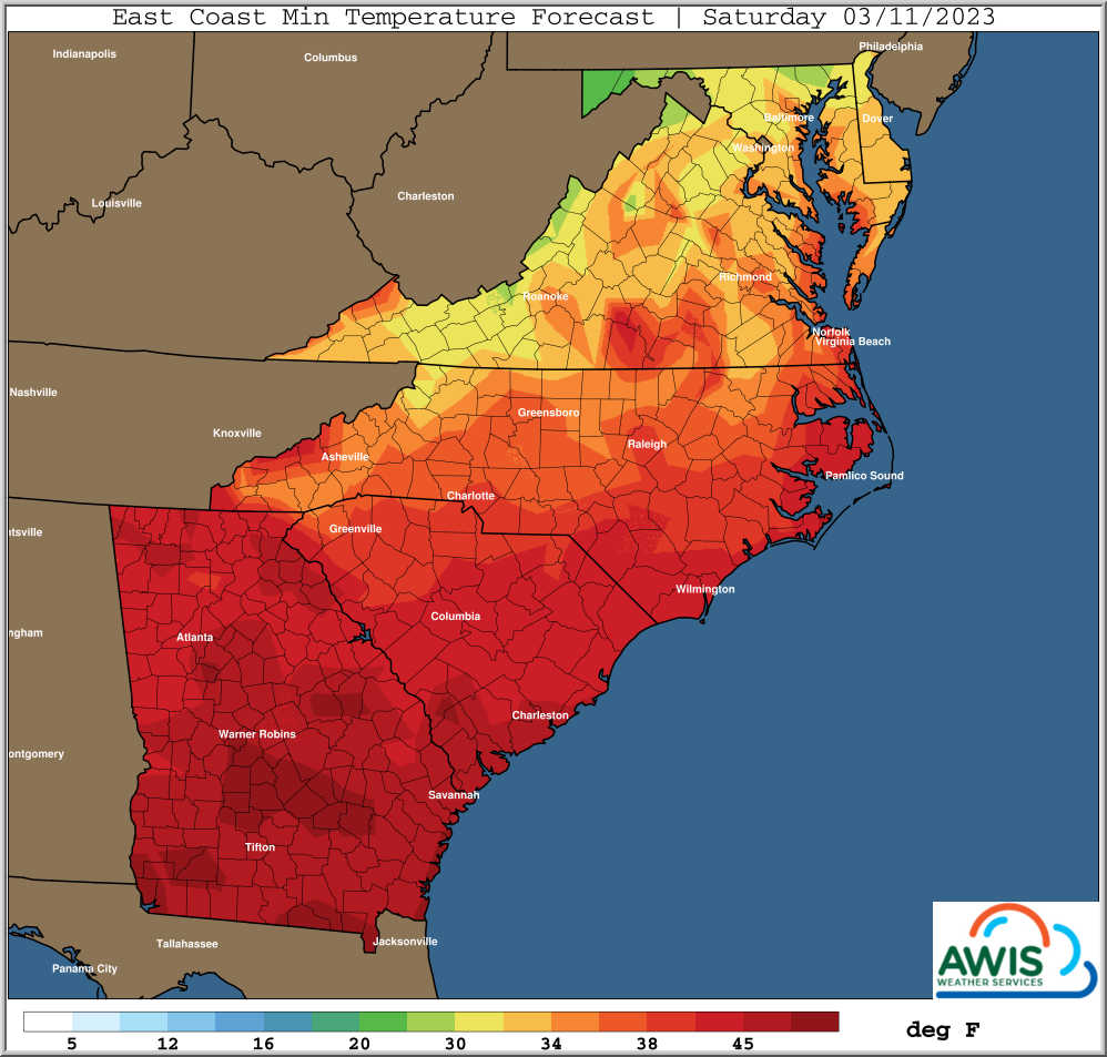
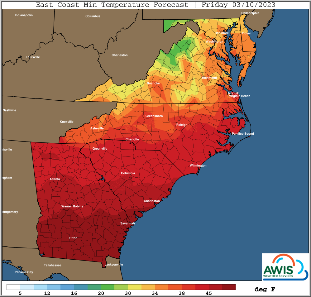
A more severe frost event is predicted for end of next week, beginning Friday, Mar 10. Maps are attached. Currently it seems that even central and parts of Eastern NC might be affected. We will keep you updated over the course of the next week.
General Discussion
For Mid-Atlantic And Most SE States
———————————–
*** Warm Many Areas Couple More Days
*** Showery Northern Areas Late Week
*** Drier Period This Weekend Into Next Week
*** Colder Periods Later Next Week Into Mid March
The first couple months of the New Year have been typical of
a La Nina type winter, and similar to last year.
This means the battle zone and storm track has frequently shifted
North and South from a mean position around the Ohio Valley to
Mid Atlantic Region.
Thus warmer than normal periods have been more frequent South of
this boundary, but have been able to push even further North
at times into the Mid-Atlantic.
Most of the true Arctic air masses have stayed just North of the
region, but with glancing blows at times across the Ohio Valley to
Mid Atlantic region as well.
Also, frequent periods of showers and storms have pushed soil moisture
to excessive levels in this battle zone, mainly from the Western
Carolinas Northward.
The warmer than normal periods, particularly over the last month, have
pushed many crops to as much as 2-3 weeks ahead of schedule,
particularly over the Southern areas into the SE states.
This will make crops highly susceptible to damage from late winter
and early spring freeze threats, where adequate protection is not
provided.
More rain and storms is in store this week for the same general areas
that do not need the rain, along with mostly above normal temperatures.
A drier period is indicated for a good part of this weekend into next
week.
Will have to watch for potential periods of colder weather moving
further South towards the end of next week, into the middle part
of March.
This may require protective measures in some areas.
Growers will need to keep updated on daily weather forecasts for
their area and potential trends and changes in the coming days
and few weeks ahead.
Minimum Temperatures & Recommendations
 Figure 1: Predicted minimum Temperatures for the Region for the coming weekend (Sunday (3/05/23) & Monday (3/06/23)).
In areas West and North of Raleigh, currently minium temperatures are predicted to be lower than 40 F. Potential for forst is higher in those areas. ONLY IF YOU ARE at more than 10 % bloom in thos areas (e.g. with early cultivars like Sweet Charlie, Rocco), it might be worth protecting your crop! Please watch your dew points closely and make an assessment based on the status of your crop.
 Figure 2: Predicted minimum Temperatures for the following weekend (Friday (3/10/23) and Saturday (3/11/23)).
Currently much of NC is predicted to experience frost conditions, beginning Friday March 10th. We will keep you posted. If you haven’t yet, it is time to bring out your rowcovers and hook up the sprinklers for this event!
Regional Forecasts:


