Storm Weather Advisory: Tropical Storm IAN: Potential Flooding
go.ncsu.edu/readext?889152
en Español / em Português
El inglés es el idioma de control de esta página. En la medida en que haya algún conflicto entre la traducción al inglés y la traducción, el inglés prevalece.
Al hacer clic en el enlace de traducción se activa un servicio de traducción gratuito para convertir la página al español. Al igual que con cualquier traducción por Internet, la conversión no es sensible al contexto y puede que no traduzca el texto en su significado original. NC State Extension no garantiza la exactitud del texto traducido. Por favor, tenga en cuenta que algunas aplicaciones y/o servicios pueden no funcionar como se espera cuando se traducen.
Português
Inglês é o idioma de controle desta página. Na medida que haja algum conflito entre o texto original em Inglês e a tradução, o Inglês prevalece.
Ao clicar no link de tradução, um serviço gratuito de tradução será ativado para converter a página para o Português. Como em qualquer tradução pela internet, a conversão não é sensivel ao contexto e pode não ocorrer a tradução para o significado orginal. O serviço de Extensão da Carolina do Norte (NC State Extension) não garante a exatidão do texto traduzido. Por favor, observe que algumas funções ou serviços podem não funcionar como esperado após a tradução.
English
English is the controlling language of this page. To the extent there is any conflict between the English text and the translation, English controls.
Clicking on the translation link activates a free translation service to convert the page to Spanish. As with any Internet translation, the conversion is not context-sensitive and may not translate the text to its original meaning. NC State Extension does not guarantee the accuracy of the translated text. Please note that some applications and/or services may not function as expected when translated.
Collapse ▲Tropical Storm Ian has the potential to cause flooding in GA, SC, NC, VA, MD
In collaboration with AWIS Weather Services
Tropical Storm Ian is expected to make a second landfall in SE-GA or SC Friday afternoon! It will bring high wind speeds to SC and GA, and heavy rainfall to the entire region! This comes during one of the most busiest times in the strawberry season: Preparation and planting. NCSU, UF and the USDA Forest Service have developed hurricane guidelines specifically for strawberry growers. We advise to follow especially the short-term preparedness guidelines.
Weather Discussion
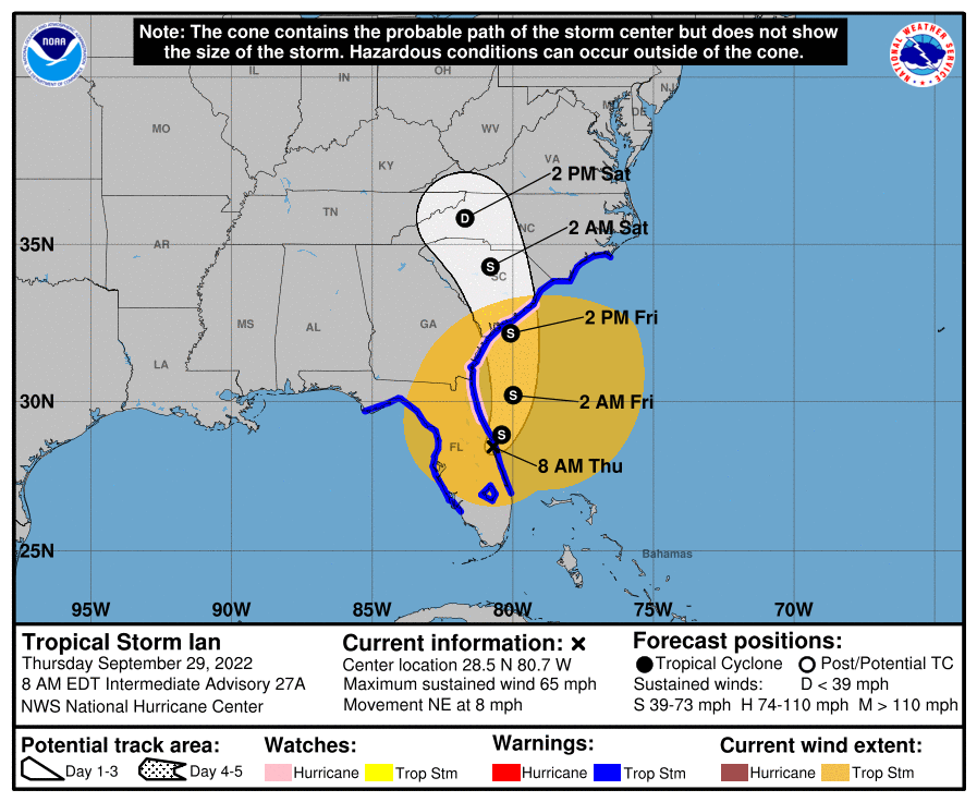
Major Hurricane Ian was moving onshore early Wednesday 09/28/2022, in the Ft Myers region of SW Florida. It did spread damaging winds and flooding rains from SW Florida through a good chunk of Interior Central and North Florida, before moving back into the Far Western Atlantic this evening, Friday morning.
There is some chance it could at least maintain some strength, or even get a little stronger prior to moving onshore again in SE-GA or SC, predicted for Friday afternoon. For now it is expected to be at minimum at tropical storm strength at this second landfall.
Growers are advised to stay alert to the latest local information as Ian continues to spread heavy rains and gusty winds inland across parts of the Southeast USA, and into at least Southern areas of the Mid-Atlantic States through this weekend into
the early part of next week.
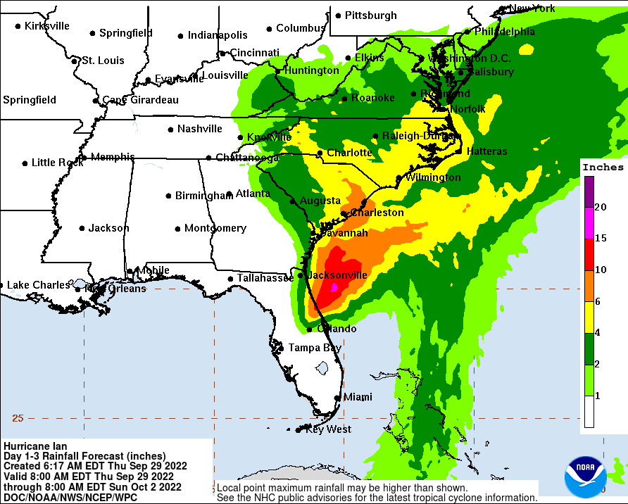
Rain totals of 2-6 inches will be common as far North as Maryland/Virginia area, and as far West as the Eastern ranges of the Southern and perhaps Central Appalachian mountains. Locally heavier totals are possible where the center of the remains tract, and in any areas of heavier rain bands. This is most likely across coastal areas of GA and the Carolinas, outside of the heavier totals across
much of the Peninsular of Florida. The slow movement of the remains of Ian will allow for even locally heavier totals, as it is not expected to get picked up and move East until the early-middle part of next week.
Forecast Maps (NOAA)
Figure 1. Upper: Predicted path of Hurricane Ian into the Southeast. Lower: Heavy rainfalls are expected in most of the Southeast and Mid-Atlantic.
Recommendations
Heavy downpours of 10-4 Inches are predicted for South Carolina, and between 6-4 Inches of rain are predicted for North Carolina (Figure 1). At this point of time, we are most concerned about flooding that can occur in strawberry fields.
We highly advise to follow the STRAWBERRY HURRICANE PREPARDENESS GUIDE for the Southeast. This guide was specifically developed for scenarios such as the predicted potential for flooding.
If you have not planted yet, but plastic mulch has been laid:
● Do not plant before the hurricane.
● Document the status of your field, block by block
● Prepare to redo some of the beds, as they may collapse.
● Make sure major access roads have ditches for water to run off.
● Check and clean ditches in production fields.
● Secure equipment that might be blown away or be flooded otherwise.
If you have already planted:
● Document the status of your field, block by block.
● Prepare to redo some of the beds, as they may collapse.
● If you are less than 4 weeks after planting date, identify a plant provider and ask
whether they can ship extra plants on short notice for replanting.
● Make sure major access roads have ditches for water to run off.
● Check and clean ditches in production fields.
● Secure equipment might be blown away or be flooded otherwise.
Diseases such as Phytophthora crown rot and anthracnose can be a big problem
in flooded fields, so you will need to closely monitor those fields after planting. After heavy flooding, plant will see nutritional damage or water stress. If you have not planted, we recommend to wait until conditions are favorable again for planting after the flood.
As always we hope that helps,
Everyone stay safe,
Mark


