AWIS Weather Update: Up and Down Temperatures the Next Weeks
go.ncsu.edu/readext?857703
en Español / em Português
El inglés es el idioma de control de esta página. En la medida en que haya algún conflicto entre la traducción al inglés y la traducción, el inglés prevalece.
Al hacer clic en el enlace de traducción se activa un servicio de traducción gratuito para convertir la página al español. Al igual que con cualquier traducción por Internet, la conversión no es sensible al contexto y puede que no traduzca el texto en su significado original. NC State Extension no garantiza la exactitud del texto traducido. Por favor, tenga en cuenta que algunas aplicaciones y/o servicios pueden no funcionar como se espera cuando se traducen.
Português
Inglês é o idioma de controle desta página. Na medida que haja algum conflito entre o texto original em Inglês e a tradução, o Inglês prevalece.
Ao clicar no link de tradução, um serviço gratuito de tradução será ativado para converter a página para o Português. Como em qualquer tradução pela internet, a conversão não é sensivel ao contexto e pode não ocorrer a tradução para o significado orginal. O serviço de Extensão da Carolina do Norte (NC State Extension) não garante a exatidão do texto traduzido. Por favor, observe que algumas funções ou serviços podem não funcionar como esperado após a tradução.
English
English is the controlling language of this page. To the extent there is any conflict between the English text and the translation, English controls.
Clicking on the translation link activates a free translation service to convert the page to Spanish. As with any Internet translation, the conversion is not context-sensitive and may not translate the text to its original meaning. NC State Extension does not guarantee the accuracy of the translated text. Please note that some applications and/or services may not function as expected when translated.
Collapse ▲AWIS Weather Update: Up and Down Temperatures the next weeks
In collaboration with AWIS Weather Services
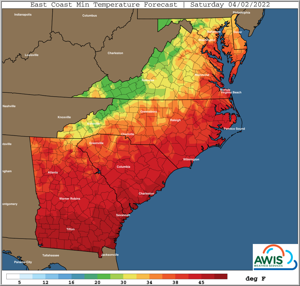
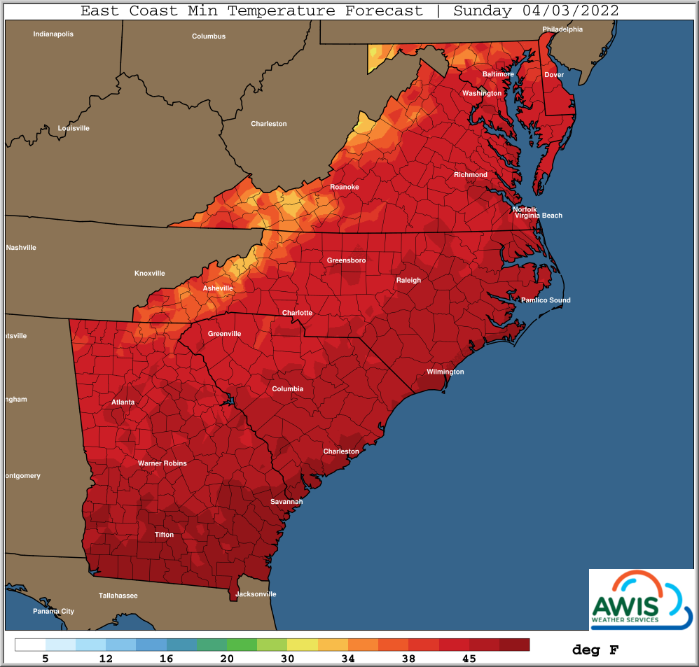
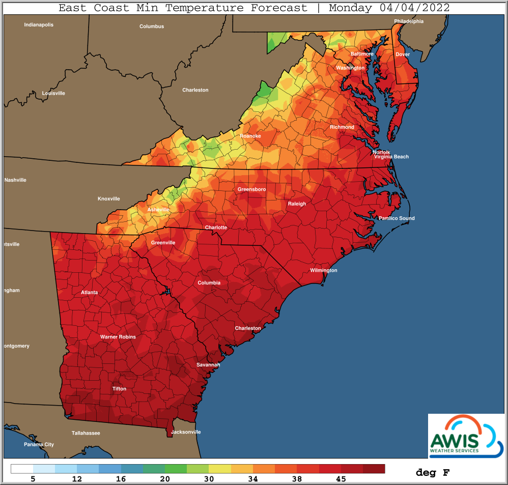
A colder night is ahead of us, with possible frost night tonight (4/1/2022) and on Monday (4/3/2022), especially Western NC and North of NC into the Mid-Atlantic. Use of row-covers and sprinklers recommended after last nights’ rain.
Temperatures will be up and down next two weeks. Be prepared for a frost/freeze late next week, reaching all the way into the interior Southeast. We will keep you updated on that.
General Discussion
*** Colder Tonight, Frost Risks Carolinas’ Northward
*** Some Frost Risks Northern Areas Monday Morning
*** Warmer Next Week
*** Wet/Stormy At Times Middle Half Next Week
*** Colder Late Next Week/Next Weekend, Increased Freeze Risk
A continued up/down weather pattern will prevail next 1-2 weeks
as a series of upper level disturbances move across the USA.
First one moves East today, with drier air advecting into most
areas this afternoon. High pressure builds in later tonight with
diminishing winds. Thus an increased risk of frost tonight,
particularly from the Carolinas’ Northward.
Potential for a locally heavy ground frost and light ground
freeze Northern areas.
Not as cold Saturday night ahead of the next quick moving upper
level disturbance.
However, back to a little colder behind that for Sunday night
and Monday morning, with a frost risk Monday morning, but not
as high a risk as tonight.
A few days of warmer weather next week as the next robust upper
level disturbance approaches from the West.
As this disturbance gets closer, expect an increase in showers
and locally strong storms to begin later Tuesday, with showery
weather possible into Thursday until disturbances moves East and
the next cold front arrives.
Rain totals of 1-2 inches, and locally more are possible next
week, highest chances for rain in southern areas.
Colder again behind the next front for late next week and next
weekend.
Next weekend will be colder than this weekend, with an increased
risk of potential freezing temperatures from the Mid-Atlantic into
parts of the Interior Southeast States.
Please remain informed of their local weather forecasts
through next weekend given these changing weather conditions.
Weather Maps:
Figure 1: Minimum Temperatures for Today (4/1/2022) to Monday (4/3/2022). Slight Frost risk in Mid-Atlantic, VA and Western NC tonight and on Monday night. We recommend to monitor your local weather and use protection methods if warranted.


