


AWIS Weather Advisory: Rain and Frost Risk for Mid-Atlantic, Virginia and Parts of NC
go.ncsu.edu/readext?861733
en Español / em Português
El inglés es el idioma de control de esta página. En la medida en que haya algún conflicto entre la traducción al inglés y la traducción, el inglés prevalece.
Al hacer clic en el enlace de traducción se activa un servicio de traducción gratuito para convertir la página al español. Al igual que con cualquier traducción por Internet, la conversión no es sensible al contexto y puede que no traduzca el texto en su significado original. NC State Extension no garantiza la exactitud del texto traducido. Por favor, tenga en cuenta que algunas aplicaciones y/o servicios pueden no funcionar como se espera cuando se traducen.
Português
Inglês é o idioma de controle desta página. Na medida que haja algum conflito entre o texto original em Inglês e a tradução, o Inglês prevalece.
Ao clicar no link de tradução, um serviço gratuito de tradução será ativado para converter a página para o Português. Como em qualquer tradução pela internet, a conversão não é sensivel ao contexto e pode não ocorrer a tradução para o significado orginal. O serviço de Extensão da Carolina do Norte (NC State Extension) não garante a exatidão do texto traduzido. Por favor, observe que algumas funções ou serviços podem não funcionar como esperado após a tradução.
English
English is the controlling language of this page. To the extent there is any conflict between the English text and the translation, English controls.
Clicking on the translation link activates a free translation service to convert the page to Spanish. As with any Internet translation, the conversion is not context-sensitive and may not translate the text to its original meaning. NC State Extension does not guarantee the accuracy of the translated text. Please note that some applications and/or services may not function as expected when translated.
Collapse ▲AWIS Weather Advisory: Rain and Frost Risk for Mid-Atlantic, Virginia and Parts of NC
in collaboration with AWIS Weather Services
Dear all,
Upcoming rain and increased frost risks especially in Western and Northern NC, Virginia and Mid-Atlantic will put us again in a difficult position, especially if row-covers are used for frost protection. Minimum air temperatures can fall below 40s in most of those areas. Predicted dew points are low and we expect mostly cloudless conditions on two consecutive nights: from Wed to Thu and Thu to Friday. There should be about half a day to let row covers dry after the rain today and tomorrow and the nights with highest frost risks (Wed-Thu, Thu-Fri). It is important to watch your local weather closely, especially if you are in Western or Northern NC, Virginia or the Mid-Atlantic.
General Discussion
*** Some Frost Risk Northern Areas Thur/Fri Mornings
*** Cooler Mid-Late Week
*** Warmer This Weekend Into Next Week
*** Few Showers, Isolated Storms Later Tuesday
*** Dry Wednesday-Early Weekend, Showers By Early Next Week
*** Perhaps Much Cooler Again ~ May 7-8, Northern Areas
The first two days of this week were likely the warmest
over the next 7-10 days.
An upper level disturbance and cold front will then move through
all areas on Tuesday. Some showers and isolated storms can be
expected ahead of the front. Most rain totals will not be that
heavy, averaging 1/2 inch or less, perhaps isolated heavier totals
mainly Eastern Carolinas and Virginia.
It will turn colder behind the front for the middle and end of
this week.
Arctic surface high pressure behind this front is further to
the North, moving from Central Canada early this week, SE through
the Upper Great Lakes at mid week and into the NE States late
this week. This will keep the coldest air further North than the
last couple cold events.
However, the potential is there for scattered frost by Thursday
morning. Highest risk will be inland areas of the Mid-Atlantic,
including Virginia, but could extend into Northern areas of
North Carolina as well.
Likely not quite as chilly Friday morning, but some patchy
frost may still be possible over the most Northern areas.
Growers, particularly over the Northern areas, need to monitor
the latest forecasts and be prepared for some protective measures
if needed.
It will turn warmer again starting Friday afternoon, into early
next week.
The next chances for showers after Tuesday evening will be late
this weekend, more likely early next week.
Potential cool down again around the beginning of the second week
of May. But for now, temperatures look to stay above freezing and
frost risk levels.
Temperature Maps
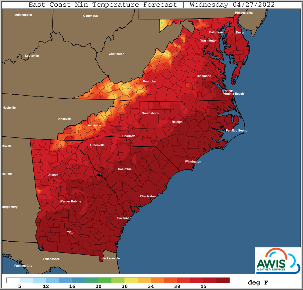
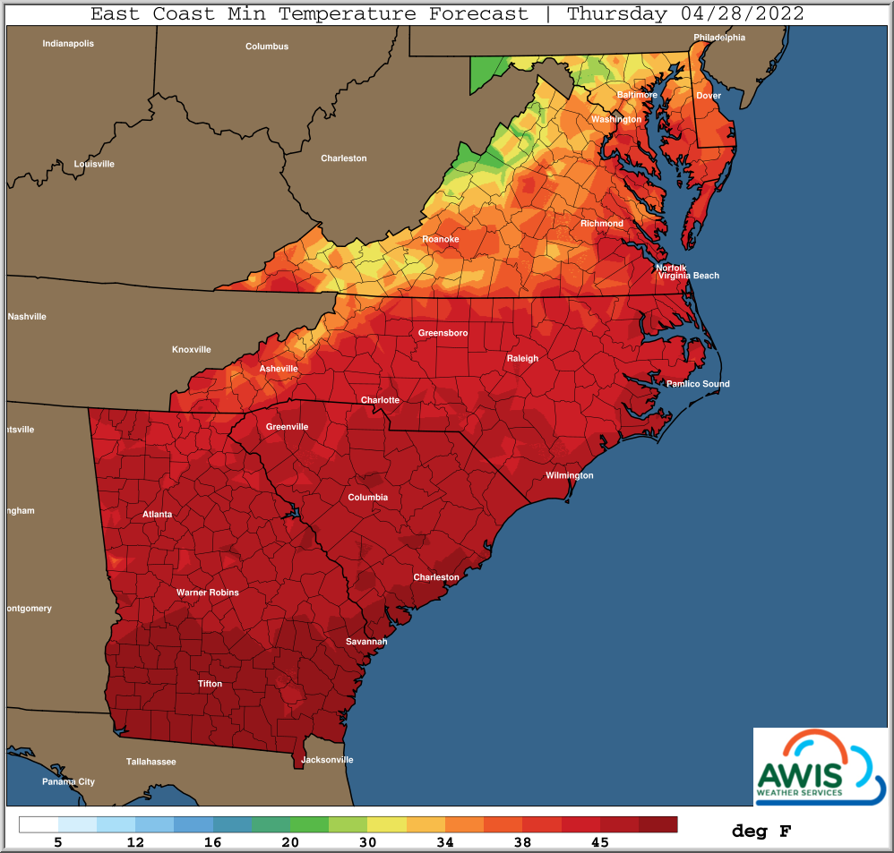
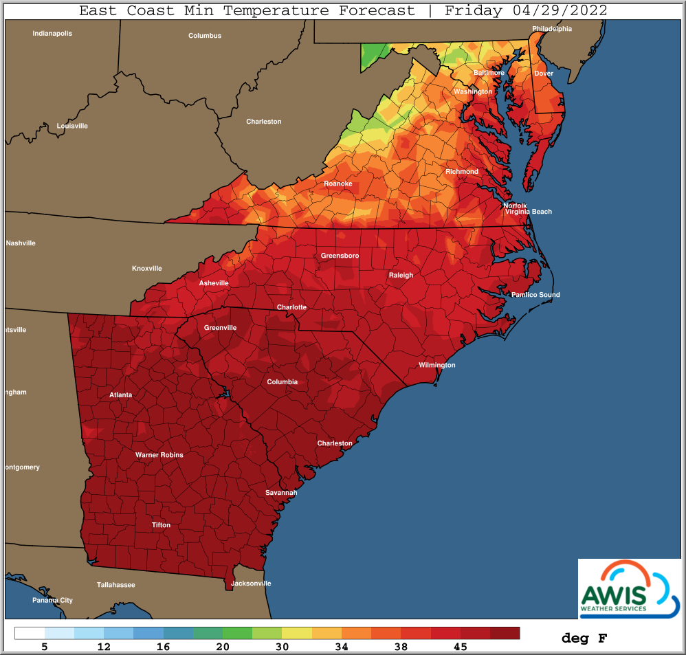
Figure 1: Predicted Minimum Temperatures for the Region.
The most important thing to do this week is: Monitor your local weather forecast! If you decide to frost protect with row-covers, several things need to be considered: If you can, don’t deploy covers before or during the rain. In most areas there should be a dry time after the rain and before the night. Control for Botrytis before covering and after taking covers off. This is especially true if you decide to cover for two days (Thu and Fri mornings)