AWIS Weather Advisory: Rain and Frost Coming Up Again
go.ncsu.edu/readext?860053
en Español / em Português
El inglés es el idioma de control de esta página. En la medida en que haya algún conflicto entre la traducción al inglés y la traducción, el inglés prevalece.
Al hacer clic en el enlace de traducción se activa un servicio de traducción gratuito para convertir la página al español. Al igual que con cualquier traducción por Internet, la conversión no es sensible al contexto y puede que no traduzca el texto en su significado original. NC State Extension no garantiza la exactitud del texto traducido. Por favor, tenga en cuenta que algunas aplicaciones y/o servicios pueden no funcionar como se espera cuando se traducen.
Português
Inglês é o idioma de controle desta página. Na medida que haja algum conflito entre o texto original em Inglês e a tradução, o Inglês prevalece.
Ao clicar no link de tradução, um serviço gratuito de tradução será ativado para converter a página para o Português. Como em qualquer tradução pela internet, a conversão não é sensivel ao contexto e pode não ocorrer a tradução para o significado orginal. O serviço de Extensão da Carolina do Norte (NC State Extension) não garante a exatidão do texto traduzido. Por favor, observe que algumas funções ou serviços podem não funcionar como esperado após a tradução.
English
English is the controlling language of this page. To the extent there is any conflict between the English text and the translation, English controls.
Clicking on the translation link activates a free translation service to convert the page to Spanish. As with any Internet translation, the conversion is not context-sensitive and may not translate the text to its original meaning. NC State Extension does not guarantee the accuracy of the translated text. Please note that some applications and/or services may not function as expected when translated.
Collapse ▲AWIS Weather Advisory: Rain and Frost Coming up Again
In collaboration with AWIS Weather Services
Dear all,
This year’s strawberry season has been so far characterized by fluctuating temperatures, often with heavier rainfalls in between temperature changes. Unfortunately not a lot will change in the next 7-10 days. We are facing rainfall especially this weekend into Monday, with increased frost threats in the Mid-Atlantic (Monday), extending to Western NC (Tuesday) and the entire region (Wednesday). There will be time to bring out dry row-covers between rain and frost night, so be patient and don’t cover with wet covers.
We also learned some lessons this year during the Mid March Frost/Freeze event. For those who chose to use row-covers during that event, winds of 30+ mph did lead to ripped covers and a loss of inflorescences and bloom due to the mechanical damage. That has impacted the past two weeks of fruit picking in Eastern NC. However, plants should be growing out of this damage at this point.
Luckily the predicted event for Mon-Wed next week will not be accompanied by higher winds and we expect a typical Hoar Frost event in most areas. Row-cover use or overhead irrigation should be the tools of choice to protect your blossoms over those days.
General Discussion
*** More Changing Weather Next 1-2 Weeks
*** Couple Rain Chances until Monday
*** Colder Early Next Week, Then Warmer Middle-End Next Week
*** Frost Risk Interior Mid-Atlantic Monday Morning
*** Frost Risk Extends A Little Further South Wednesday Morning
*** More Changing Weather Towards End Of April
A fast upper level flow over the Northern 2/3rds of the USA will
keep weather changing over the next 1-2 weeks, as multiple fronts
combined with multiple upper level disturbances move across the
country.
The next frontal boundary will move through early this weekend.
Best rain chances with that will be over Southern areas, where
locally one inch of rain is possible, but most areas closer to
1/2 inch or less.
Briefly cooler behind that for late this weekend into Monday morning.
Northern growers, particularly inland Mid-Atlantic, need to watch
local forecasts closely for Monday morning, for potential scattered
ground frost.
Then the next potential rain making system will come later next
Monday, with low pressure possibly developing and moving NE along
the Carolina coastline. This could result in some local rain
totals of an inch or more, mainly closer to the Atlantic Coast.
Behind that a brief surge of colder air again, with a threat of
frost a little further South into the Carolinas, mainly next
Wednesday morning.
Potential for some patchy to scattered frost as early as next
Tuesday morning in the more Western areas along the Appalachian
foothills.
Then a warming pattern for the middle-end of next week, along
with dry weather.
Looking further ahead, next threat of some showers and storms
about 10 days from now, around April 25-26 followed by another
cool down, mainly for the Mid-Atlantic, with some potential frost
risks around April 27-29 time frame.
Updates next week and after as needed.
Happy Easter weekend!
Temperature Maps and Recommendations
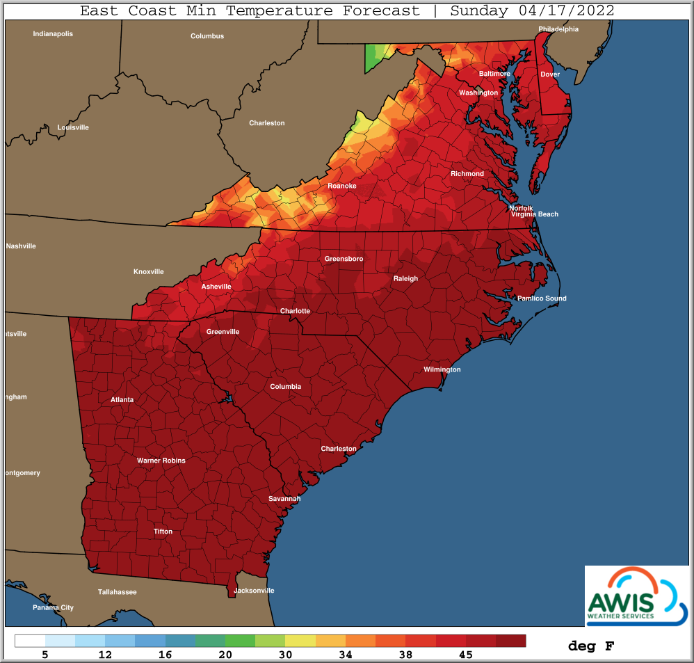
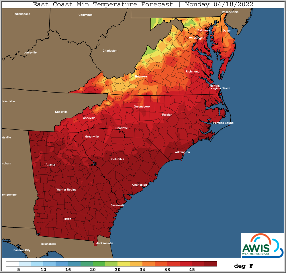
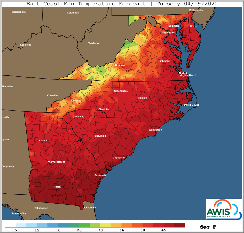
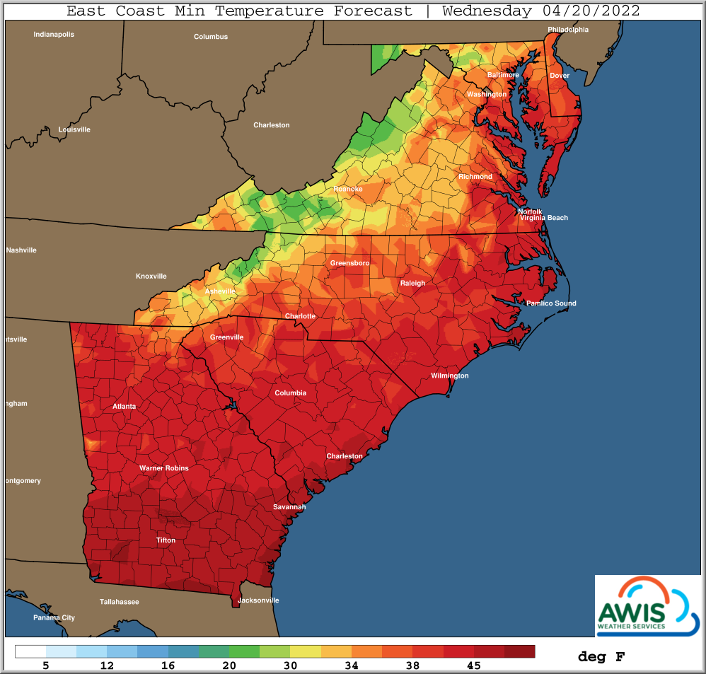
Figure 1: Predicted Min. Temperatures for the Region from Easter Sunday (4/17/2022) to Wednesday (4/20/2022). Frost threats increase especially by mid week.
Please look at your regional weather forecast. There will be rain in most areas especially in Monday, leading to soaking row covers if deployed before Tuesday. This can be a problem especially in Virginia, Western NC and the Mid-Atlantic, where early cultivars might already showing blossoms. Wet row-covers might cause more damage to your blossoms that doing nothing. On the other hand, if you only expect a light rainfall and you expect your covers to dry, they might save your blossoms during the nights from Sunday to Monday. It is imperative to consult your local weather forecast to make a judgment call.
For most of North Carolina, the two important nights to protect your crop is the night from Monday to Tuesday and from Tuesday to Wednesday. The last rain, as predicted right now, should be moving through NC Monday afternoon and there will be time to deploy dry row-covers. We will see higher winds on Tuesday (sprinkler use might be critical) that will slow down until Tuesday night to Wednesday.
Please ALWAYS look at the predicted temperatures, dew points and wet bulbs for your specific region, and keep wind and rain in mind.


