AWIS Weather Advisory (4/7): Watch Out for More Frost This Weekend
go.ncsu.edu/readext?858650
en Español / em Português
El inglés es el idioma de control de esta página. En la medida en que haya algún conflicto entre la traducción al inglés y la traducción, el inglés prevalece.
Al hacer clic en el enlace de traducción se activa un servicio de traducción gratuito para convertir la página al español. Al igual que con cualquier traducción por Internet, la conversión no es sensible al contexto y puede que no traduzca el texto en su significado original. NC State Extension no garantiza la exactitud del texto traducido. Por favor, tenga en cuenta que algunas aplicaciones y/o servicios pueden no funcionar como se espera cuando se traducen.
Português
Inglês é o idioma de controle desta página. Na medida que haja algum conflito entre o texto original em Inglês e a tradução, o Inglês prevalece.
Ao clicar no link de tradução, um serviço gratuito de tradução será ativado para converter a página para o Português. Como em qualquer tradução pela internet, a conversão não é sensivel ao contexto e pode não ocorrer a tradução para o significado orginal. O serviço de Extensão da Carolina do Norte (NC State Extension) não garante a exatidão do texto traduzido. Por favor, observe que algumas funções ou serviços podem não funcionar como esperado após a tradução.
English
English is the controlling language of this page. To the extent there is any conflict between the English text and the translation, English controls.
Clicking on the translation link activates a free translation service to convert the page to Spanish. As with any Internet translation, the conversion is not context-sensitive and may not translate the text to its original meaning. NC State Extension does not guarantee the accuracy of the translated text. Please note that some applications and/or services may not function as expected when translated.
Collapse ▲AWIS Weather Advisory (4/7): Watch out for more Frost this weekend
In collaboration with AWIS Weather Services
Dear all,
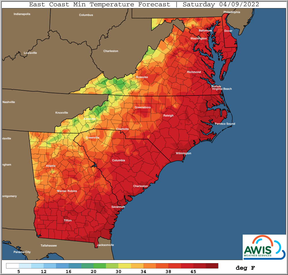
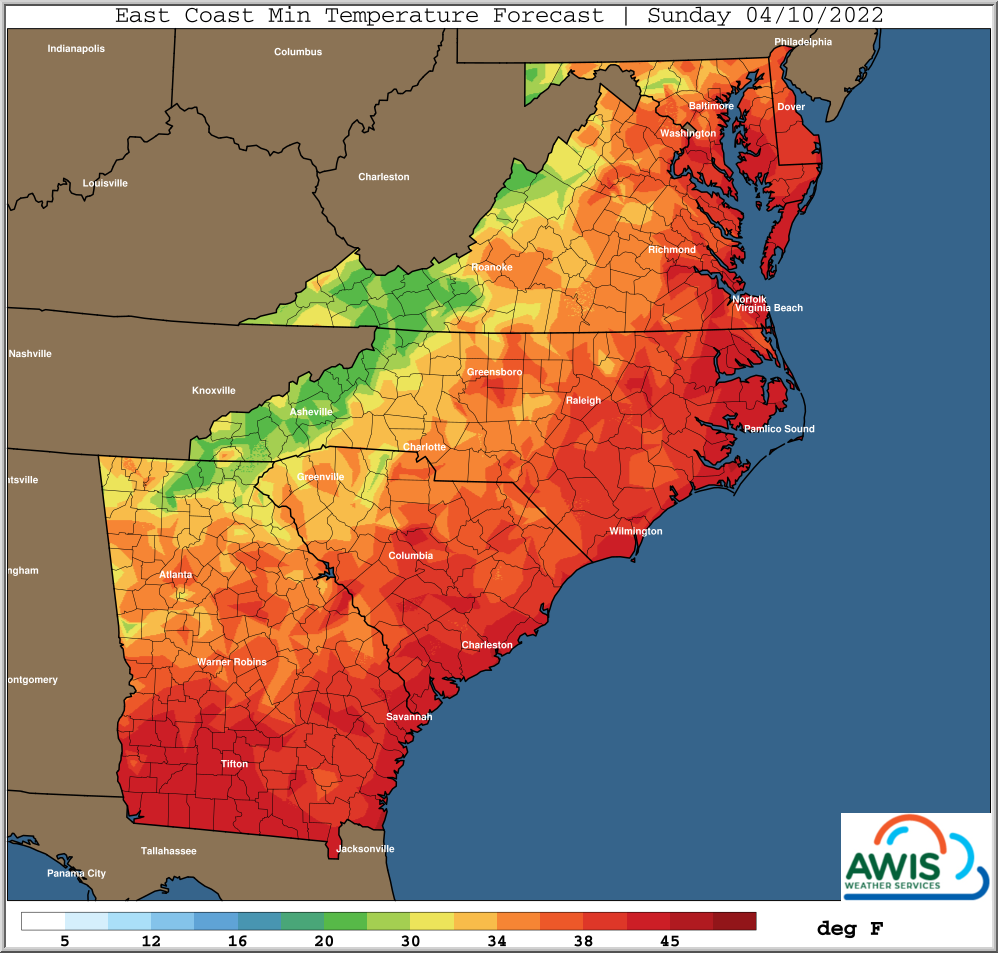
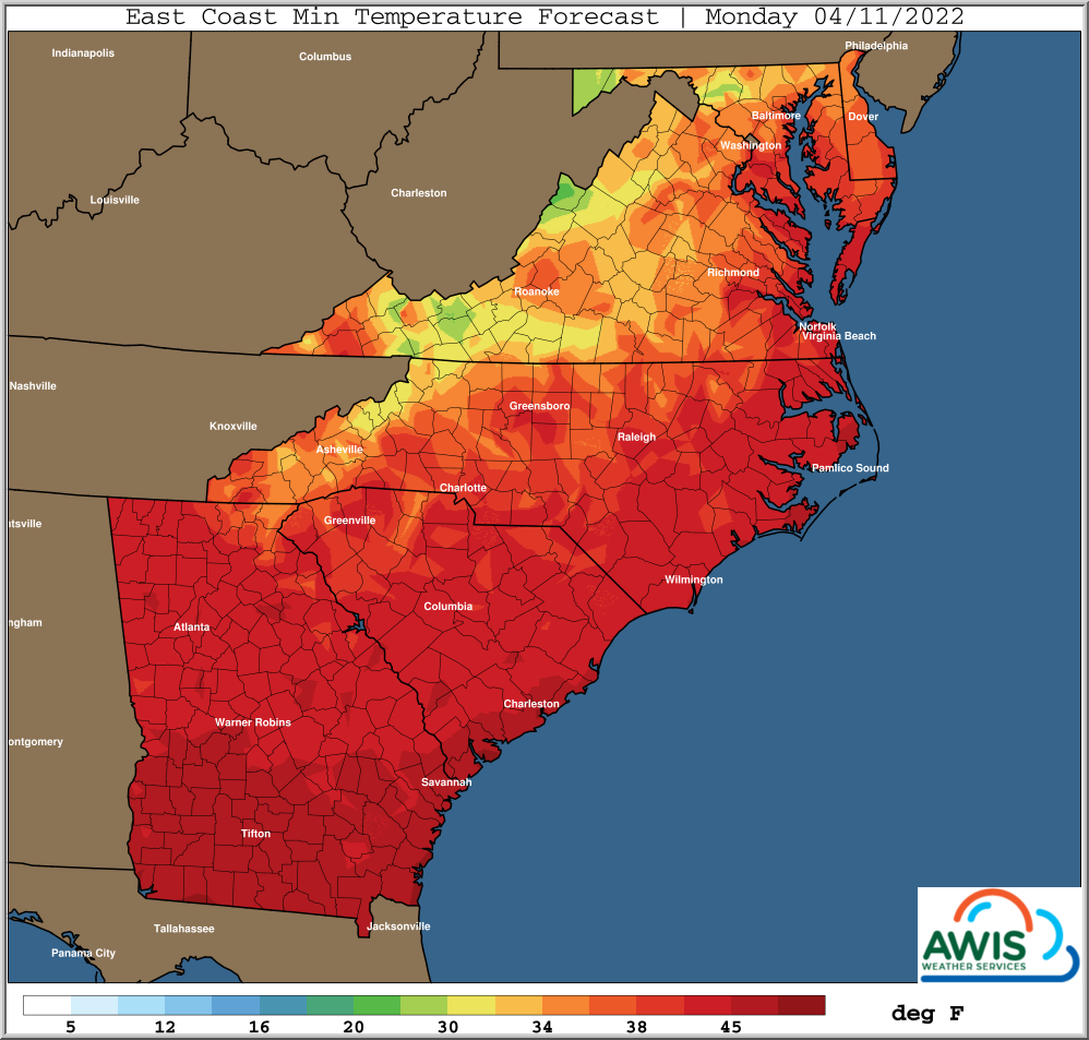
Strawberry season is in full swing in most of North Carolina. But we are still in early April. That means the threat of frost/freeze events is real. With plenty of blossoms open and fruit on the plants, you will need to protect if you local weather predicts frost. Highest frost threats will be Sunday (4/10) and Monday (4/11) mornings, with some areas in the West seeing Frost already on Saturday (4/9).
Early April unfortunately also means that trends of warm and cold weather and heavy rainfalls in between will continue over the next two weeks. If you use row-covers, be prepared to move them a lot on and off your plants.
General Discussion
*** Freeze/Frost Threat Returns
*** Warmer Next Week
A continued trend of multiple upper level disturbances moving
from West to East will prevail in the next couple weeks.
This will mean the recent trends of showers and storm
chances every few days, with warming ahead of each one, and
colder behind them to continue.
It is still begin of April. We are ahead of schedule with the strawberry season in most of the Southeast, but it also means we have to protect more often.
Highest freeze and frost risks looks to be Sunday (4/10) and Monday (4/11) morning,
but a few Western and Northern areas could experience a freeze
or frost as early as Saturday morning.
Continued potential issues with handling of wet crop covers
can be expected given the anticipated rain ahead of the next cold.
Warmer temperatures are likely to resume Sunday afternoon
through the middle of next week.
Temperatures Maps & Recommendations
Figure 1: Minimum Temperatures for the region from 4/9-4/11 2022.
Please monitor you current weather, and especially predicted wet bulb and dewpoint temperatures for your location. We are facing a frost threat in the coming days. Clear nights with min temperatures in the 30s can already cause damage to you blossoms (Table 1).
The use of row-cover or overhead sprinklers should protect your plants from the predicted frost threat this weekend. In most regions there should be enough time between rainfalls and the need to use row covers to minimize the threat of wet row-cover damaging the plants. If overhead is used, it is also important to start early, especially with low predicted dew-points. We have a detailed basic strawberry frost protection seminar that you should watch to learn more on frost protection especially: 2022 Strawberry Cold Protection 101
Table 1: These are the temperatures at plant level that will damage your plant. Pleas be aware that air temperatures in a frost event can be much higher. Watch for dew points!!
| Plant Growth | Transition | New Leaf/New Growth | ||
| Bud Physiology | Buds inside crown | Buds inside crown | Emerged buds | Popcorn/early season open blossom |
| Cold Hardiness | Hardy to mid-teens | 20-25F | 28F | |


