AWIS Weather Advisory: Protect Plants This Weekend!
go.ncsu.edu/readext?853184
en Español / em Português
El inglés es el idioma de control de esta página. En la medida en que haya algún conflicto entre la traducción al inglés y la traducción, el inglés prevalece.
Al hacer clic en el enlace de traducción se activa un servicio de traducción gratuito para convertir la página al español. Al igual que con cualquier traducción por Internet, la conversión no es sensible al contexto y puede que no traduzca el texto en su significado original. NC State Extension no garantiza la exactitud del texto traducido. Por favor, tenga en cuenta que algunas aplicaciones y/o servicios pueden no funcionar como se espera cuando se traducen.
Português
Inglês é o idioma de controle desta página. Na medida que haja algum conflito entre o texto original em Inglês e a tradução, o Inglês prevalece.
Ao clicar no link de tradução, um serviço gratuito de tradução será ativado para converter a página para o Português. Como em qualquer tradução pela internet, a conversão não é sensivel ao contexto e pode não ocorrer a tradução para o significado orginal. O serviço de Extensão da Carolina do Norte (NC State Extension) não garante a exatidão do texto traduzido. Por favor, observe que algumas funções ou serviços podem não funcionar como esperado após a tradução.
English
English is the controlling language of this page. To the extent there is any conflict between the English text and the translation, English controls.
Clicking on the translation link activates a free translation service to convert the page to Spanish. As with any Internet translation, the conversion is not context-sensitive and may not translate the text to its original meaning. NC State Extension does not guarantee the accuracy of the translated text. Please note that some applications and/or services may not function as expected when translated.
Collapse ▲AWIS Weather Advisory: Protect plants this weekend.
First posted: 3/09/2022; Updated 3/10/2022
Dear all,
Temperatures will drop in the Mid-Atlantic and Southeast into the mid 20s in many areas over the weekend, with the coldest night being Saturday to Sunday. Wind and rain beforehand will make protection difficult. While plants in the mid-Atlantic are still under covers, and the crop on Western NC is not as advanced, especially growers in GA, SC and Eastern NC will have to watch out to protect possible blooms and flower buds. Growers in the Piedmont or Western NC might have a a less advanced crop. Your goal is to protect plants from possible damage to tight flower buds or crown damage.
Table 1.: These are the temperatures at plant level that will damage your plant. Pleas be aware that air temperatures in a frost event can be much higher.
| Dormancy | Transition | New Leaf | ||
| Buds inside crown | Buds inside crown | Buds inside crown | Emerged buds | Popcorn/early season open blossom |
| Hardy to 10F | Hardy to mid-teens | 20-25F | 28F | |
We will see the first large temperature drop from Friday to Saturday, and then another one from Saturday to Sunday. The upcoming weather is a critical situation, especially for growers in Southern parts of the region. Possible rain might wet covers. Wet row-covers might be affected by the freeze and subsequent wind, causing potential damage to flowers. While I don’t think that we have as much problems in areas with blooms, it will be extremely important for growers in GA, SC and Eastern NC with advanced crops to look at your regional dew point. Double covering might be an option. Wind speeds might prohibit the use of sprinklers over covers.
The alternative, doing nothing, can also be detrimental, especially if you have open blossoms! there is a chance for growers in the coastal regions South to use DRY covers on for the one night from Saturday to Sunday!
We recommend to check your weather and the status of your plants, Critical nights for most areas are from Fri to Mon.
If you chose to put on row-covers for more than one night, we also recommend to spray for Botrytis and Anthracnose beforehand. The strawberry risk map can help you determine the risk of infection in your field:
http://agroclimatenc.ncsu.edu/plantdisease/strawberry.aspx
Be careful using row covers when they are wet, they might freeze and can cause damage to your plants as well.
General Discussion (Updated 3/10/2022)
*** Much Colder This Weekend
*** Hard Freeze Threat Many Areas Sunday Morning
*** Lingering Freeze/Frost Threat Some Areas Monday Morning
*** Warmer Next Week
*** Watching March 24-25 For Potential Colder Air Mass To The North
*** Otherwise, More Frequent Warmer Periods Return After This Weekend
The main upper level trough of low pressure currently over the
Eastern Rockies and Midwest will shift East late this week and
weekend, as several upper level disturbances rotate through it.
This means periods of rain in some areas, with isolated heavier
showers and storms.
Best rain chances will be Mid-Atlantic and Eastern areas of the
Southeast today, and mostly Southern areas of SE late this week.
Heavier rain and isolated storms may spread into many areas later
Friday into Saturday as low pressure moves NE ahead of a very
strong cold front.
Most rain total ahead of this strong cold front should be near
or under 1 inch, but locally heavier.
However, with nearly daily rain chances in the more Southern areas
of the Southeast into Saturday, rainfall may accumulate 2-4 inches,
and locally heavier, particularly Southeast 1/3 of Georgia.
Main story then will be a turn to windy and much colder weather
Saturday as the main upper level trough finally pushes East, allowing
a surface Canadian/Arctic high pressure center to push South and
Southeast, deep into the Southern Mississippi Valley, and then
ridging into the Tennessee Valley Region to end the weekend.
It will turn windy and colder from the North and West late Friday
night and Saturday. The surface high pressure ridge will likely
settle over the Southern Mississippi to Tennessee Valley Regions
late Saturday night and Sunday morning. This will allow winds to
diminish, increasing the freeze threat for many areas.
Timing of the drop off of winds will be critical, as potential for
cold air advection into Saturday night to lower dew point temperatures
into the teens deep into the South, even perhaps single digits further
North.
While expecting dew points to slowly rise late Saturday night and
Sunday morning, due to wetter soils, and slowly diminishing impacts
of cold air advection as wind begin to diminish, it may not be enough
to prevent many areas from dropping into hard freeze ranges by near
to shortly after sunrise Sunday morning, meaning middle 20s if not
lower.
There is some potential for colder pockets, particularly more Western
areas, closer to the surface ridge with longer periods of lighter
winds Sunday morning, to get below 20 degrees.
This threat of a major freeze will extend deep into the Southeast
states, perhaps as far South as South Georgia, where a significant
frost potential will add to the potential freeze danger.
Given lighter winds, the potential for temperatures near ground level,
for areas unprotected, could be several degrees colder than the
forecasts given above, with the anticipated radiational cooling that
likely will take hold closer to sunrise Sunday morning.
Over-all, the timing of the surface ridge behind the cold air advection,
is almost a worse case scenario in maximizing the cold potential,
particularly in areas that get the lightest winds Sunday morning.
Areas closer to the Atlantic Coast and furthest North may have enough
wind to linger to help limit the coldest potential some on Sunday
morning.
Not nearly as cold Monday morning, but still some freeze threat, with
higher frost risk as well for some areas, particularly more Eastern
and Northern areas.
It will be critical for growers to stay vigil of the latest forecast
information for their local areas and be prepared to take the
necessary actions as needed, if not already completed for some.
Looking further ahead during this time of year is dangerous given the
potential errors with timing and degree of accuracy of forecasts.
However, some potential for colder air masses to move closer or into
the USA around the 2 week period ahead, for now that would be around
March 24-25.
Otherwise, the longer range outlooks would favor a return to more
frequent periods of above normal temperatures.
Updates on future cold potential will be disseminated as needed.
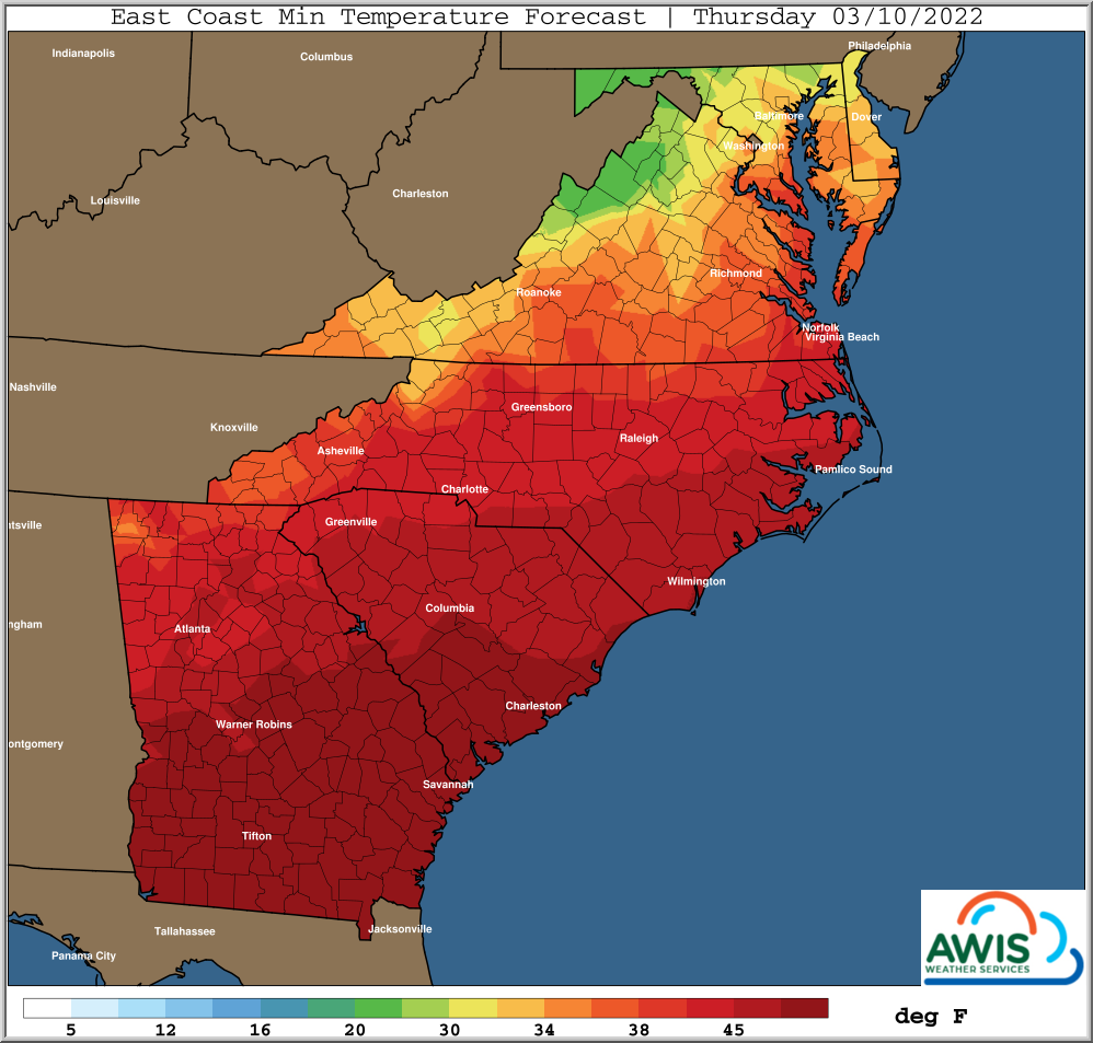
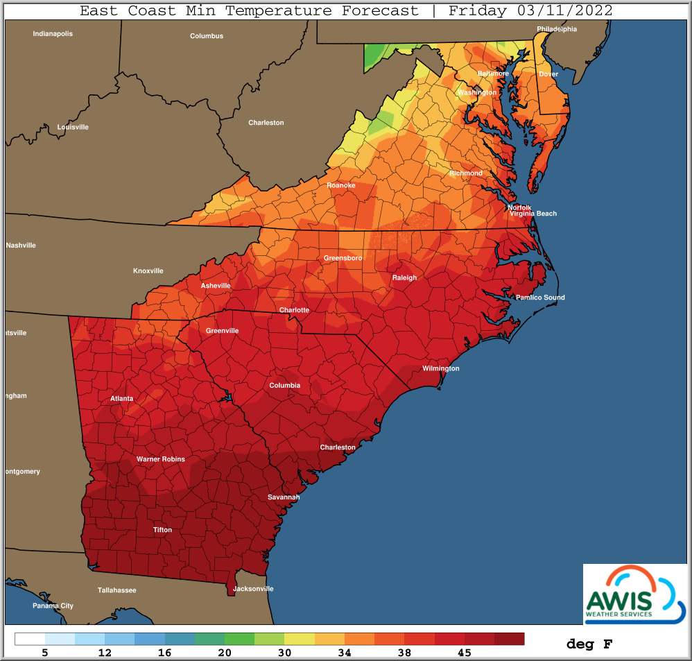
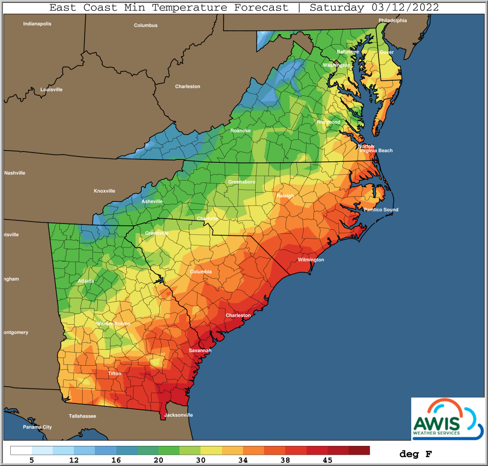
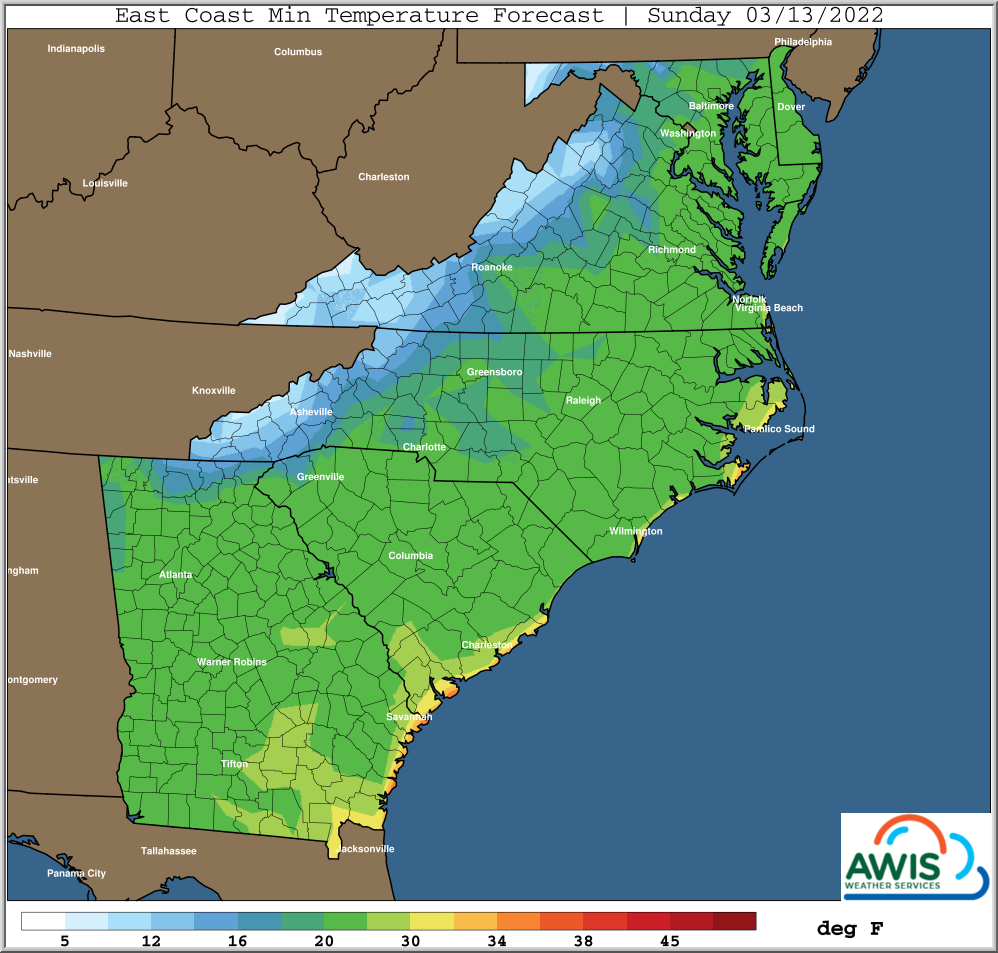
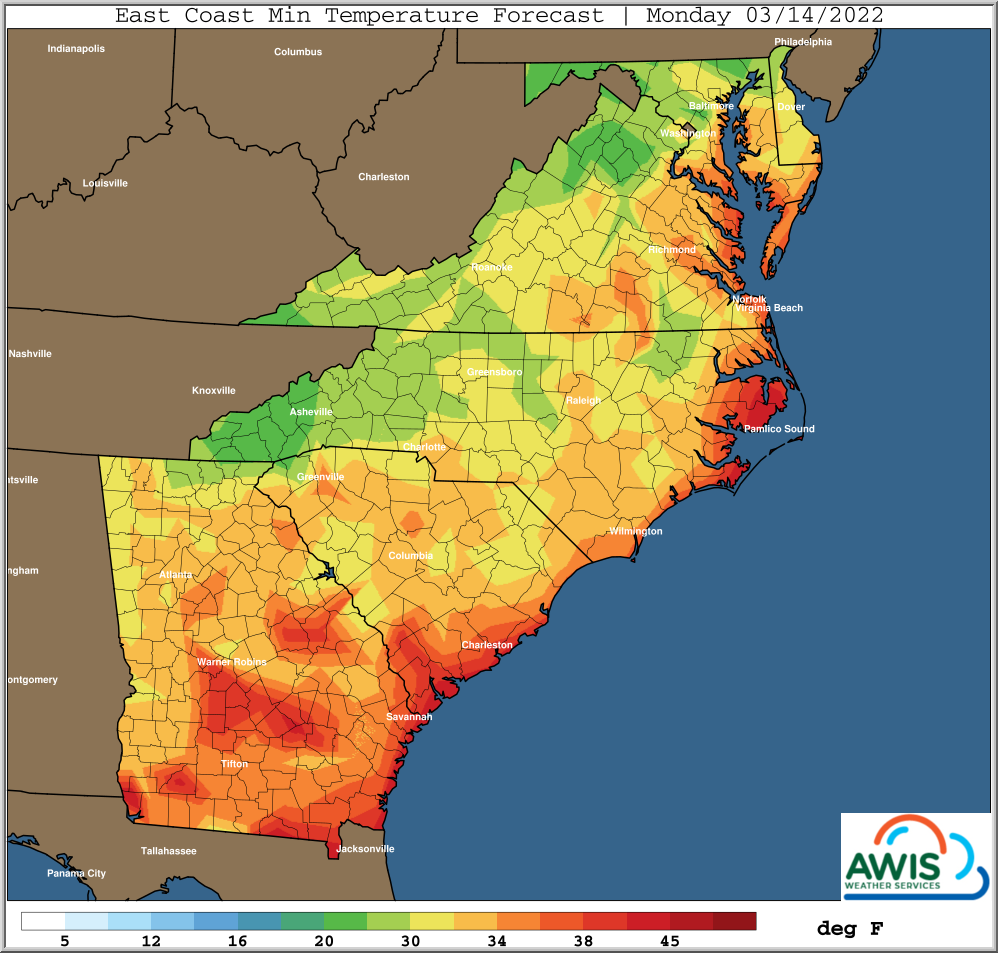
Min Temperatures for the Region
Figure 1: Minimum Temperatures for the region. A freeze/frost event will affect most of the area, including most of the Southeast. We recommend to protect plants if temperatures drop below 32 in your region. Especially the night from Saturday to Sunday will be critical!
Recommendations:
For most of NC, the nights from Friday to Monday will be critical. The use of row-covers depends on the stage of your crop and your local weather forecast. The further advanced your crop is, the more critical is protection. However, row cover use can be difficult. If you use row covers, several things are important:
a) Make sure you control foliar diseases before using covers.
b) Study your weather and your plants! In some areas it will rain, covers will be wet and might cause more damage than good, especially for the night from Friday to Saturday. It might be better to wait and use covers on Saturday. However, you risk frost damage Saturday morning, with dew points dropping fast from Friday to Saturday.
In areas further South, especially in GA and South SC, with an advanced crop and open blossoms on plants, protection will be critical in order to save those flowers, especially from Saturday to Sunday! Not protecting will most likely affect the first week of harvest.
Please study in detail your local weather forecast as well as your crop status, to know which weather you will anticipate in your particular field.
This is a very difficult situation, due to the fast drop of temperatures and the rain ahead of that. A detailed knowledge of your crop and local weather will be detrimental to make the right decisions on protection. Feel free to ask me any questions any time.
Regional Forecasts:
North Carolina
South Carolina:
Georgia:
Virginia:
Maryland:
Mark


