AWIS Weather Advisory: Not as Cold as Initially Predicted, but Stay Alert
go.ncsu.edu/readext?850973
en Español / em Português
El inglés es el idioma de control de esta página. En la medida en que haya algún conflicto entre la traducción al inglés y la traducción, el inglés prevalece.
Al hacer clic en el enlace de traducción se activa un servicio de traducción gratuito para convertir la página al español. Al igual que con cualquier traducción por Internet, la conversión no es sensible al contexto y puede que no traduzca el texto en su significado original. NC State Extension no garantiza la exactitud del texto traducido. Por favor, tenga en cuenta que algunas aplicaciones y/o servicios pueden no funcionar como se espera cuando se traducen.
Português
Inglês é o idioma de controle desta página. Na medida que haja algum conflito entre o texto original em Inglês e a tradução, o Inglês prevalece.
Ao clicar no link de tradução, um serviço gratuito de tradução será ativado para converter a página para o Português. Como em qualquer tradução pela internet, a conversão não é sensivel ao contexto e pode não ocorrer a tradução para o significado orginal. O serviço de Extensão da Carolina do Norte (NC State Extension) não garante a exatidão do texto traduzido. Por favor, observe que algumas funções ou serviços podem não funcionar como esperado após a tradução.
English
English is the controlling language of this page. To the extent there is any conflict between the English text and the translation, English controls.
Clicking on the translation link activates a free translation service to convert the page to Spanish. As with any Internet translation, the conversion is not context-sensitive and may not translate the text to its original meaning. NC State Extension does not guarantee the accuracy of the translated text. Please note that some applications and/or services may not function as expected when translated.
Collapse ▲AWIS Weather Advisory: Upcoming cold front no reason for concern – at the moment.
In collaboration with AWIS Weather Services
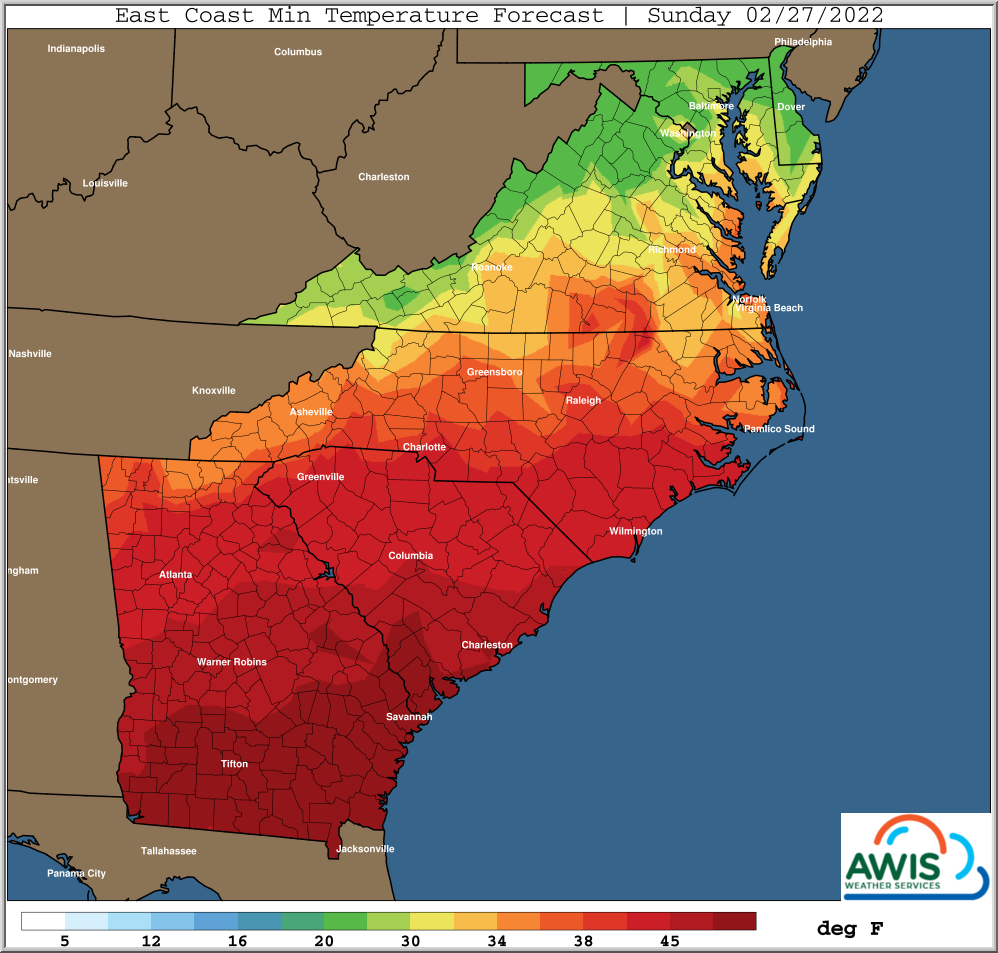
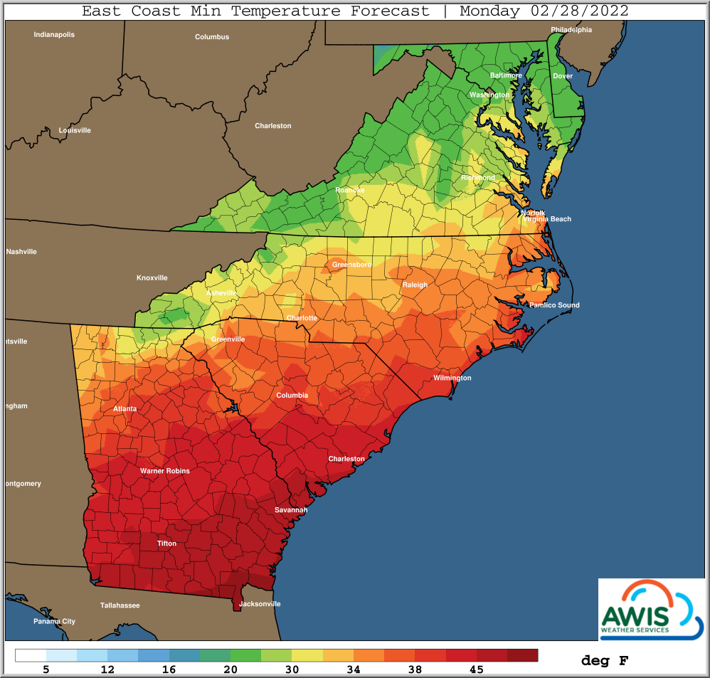
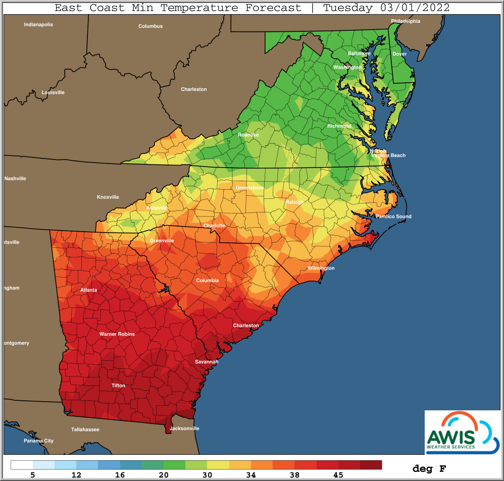
The current few warm days are followed by colder weather early next week, with hard freeze min temperatures in the Mid-Atlantic, Virgina and Northern and Western NC. Minimum temperatures can drop into mid 20s in those regions.
More southern regions with advanced crop stages, (e.g. in Southern GA) might be impacted by potential frost, especially during the night from Monday to Tuesday.
Currently we don’t think that crop protection is necessary in most regions. However, weather during this season is particularly hard to predict. We are monitoring the weather development constantly, but please stay alert and monitor your local weather forecasts as well.
General discussion:
Main point to pass along is that cold arctic air masses
moving into the USA from Canada through the early part of
next week will stay a little further North than anticipated
a few days ago.
This will minimize the threat of significant freeze
events, particularly from Southern Virginia and points
South.
Temperatures may still reach near hard freeze levels over
Interior Mid-Atlantic early next week, but even there it
will not be nearly as cold as the potential seen a few
days ago.
Main reasons are the center of the polar vortex located
over the Hudson Bay area of Canada, and points North, will
rotate disturbances around it further East than South, thus
keeping the coldest air masses from penetrating deeper into
the USA. An upper level ridge of high pressure over the Gulf
of Mexico, will weaken some and shift Southward, but not
as much as earlier thought. Combine this with multiple
upper level disturbances moving in from the Pacific, and
you get a very complicated pattern, that is very difficult
to forecast for, particularly for forecast days 5+ into the
future.
More the reason for growers to stay aware of daily weather
forecasts for potential changes in anticipated previous weather
trends. The transition from winter to spring season typically
is the hardest to forecast, as small changes can result in
large down-stream effects as warm air and cold air try to
balance each other out.
A main concern will be warm periods to return later next
week, setting up the potential for damaging cold events
down the road. It is very early in the freeze/frost
protection season.
Regional Weather Maps for Early next week:
Figure 1: Minimum Temperature for the Region from 2/27/2022 – 3/1/2022
Be Prepared and stay alert:
Cold protection depends on the physiological stage of your strawberry plant. The most vulnerable stage are open blossoms (Table 1). Especially during frost events in early spring, temperatures at the tissue can easily drop to dangerous levels. At the moment, it is most important to begin monitoring your weather frequently. Please also join our Cold and Frost Protection webinar next week to get a timely refresher on the basics.
Table 1.: These are the temperatures at plant level that will damage your plant. Pleas be aware that air temperatures in a frost event can be much higher.
| Dormancy | Transition | New Leaf | ||
| Buds inside crown | Buds inside crown | Buds inside crown | Emerged buds | Popcorn/early season open blossom |
| Hardy to 10F | Hardy to mid-teens | 20-25F | 28F | |


