AWIS Weather Forecast: Cold Weather Ahead
go.ncsu.edu/readext?841370
en Español / em Português
El inglés es el idioma de control de esta página. En la medida en que haya algún conflicto entre la traducción al inglés y la traducción, el inglés prevalece.
Al hacer clic en el enlace de traducción se activa un servicio de traducción gratuito para convertir la página al español. Al igual que con cualquier traducción por Internet, la conversión no es sensible al contexto y puede que no traduzca el texto en su significado original. NC State Extension no garantiza la exactitud del texto traducido. Por favor, tenga en cuenta que algunas aplicaciones y/o servicios pueden no funcionar como se espera cuando se traducen.
Português
Inglês é o idioma de controle desta página. Na medida que haja algum conflito entre o texto original em Inglês e a tradução, o Inglês prevalece.
Ao clicar no link de tradução, um serviço gratuito de tradução será ativado para converter a página para o Português. Como em qualquer tradução pela internet, a conversão não é sensivel ao contexto e pode não ocorrer a tradução para o significado orginal. O serviço de Extensão da Carolina do Norte (NC State Extension) não garante a exatidão do texto traduzido. Por favor, observe que algumas funções ou serviços podem não funcionar como esperado após a tradução.
English
English is the controlling language of this page. To the extent there is any conflict between the English text and the translation, English controls.
Clicking on the translation link activates a free translation service to convert the page to Spanish. As with any Internet translation, the conversion is not context-sensitive and may not translate the text to its original meaning. NC State Extension does not guarantee the accuracy of the translated text. Please note that some applications and/or services may not function as expected when translated.
Collapse ▲Cold Weather ahead from Monday to Wednesday
In collaboration with AWIS Weather Services
Dear all,
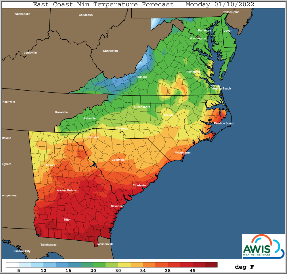
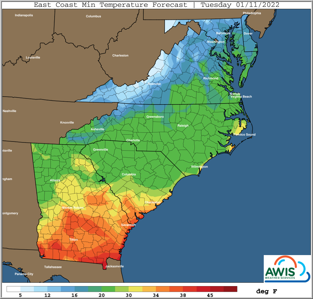
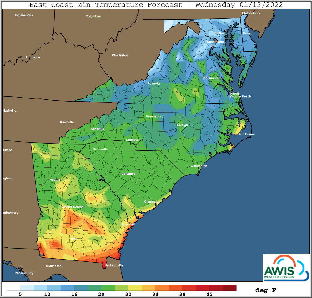
Winter-ish is finally here. After a short period of rain and warmer weather tomorrow (Sunday Jan 8), temperature will drop again from Monday to especially the night from Tuesday to Wednesday, when large areas of VA and NC are in the teens (see Figure 1). In regions where the minimum temperatures are below 20, we recommend to use row-covers to avoid injury to the crowns. If you already have row covers on your plant, do NOT remove them for Sunday. As usual, we start with a short discussion of weather and then recommendations.
Weather discussion:
*** Briefly Warmer Sunday/Early Monday
*** Mostly Rain Event Ahead Of Next Cold Front
*** Much Colder Again Later Monday Into Early Wednesday
*** Periods of Cold Continue Into Late January
*** Potential To Trend Back To Warmer/More Frequently By End Of January
The most recent snow storm affected areas a little further North and West
than previous storm, with heaviest totals from the Northern areas of VA/MD
Westward into the Central Appalachians, where 6+ inches of snow were
reported. Much lesser totals to the East and South, in areas where the
heaviest snows were focused with the previous storm.
This storm is now well out into the Atlantic, so the next cold event
will take place tonight. Surface high pressure will drift Eastward
towards VA by daylight Saturday morning. This will allow winds to
subside to periods of calm, particularly Northern and Western Carolinas
Northward to VA/MD areas. With dew points in the lower teens North to
mid-upper teens South, expect rapid fall in temps at sunset tonight,
with minimums near to just after sunrise Saturday morning.
Minimums as cold as recently can be expected in many areas, perhaps even
colder Southern areas than recent past. That puts them into the lower
end of teens inland Mid-Atlantic, perhaps even into the teens colder
Northern and Western areas of NC, into parts of NW SC.
Given light winds, the usual coldest pockets will show up a few degrees
lower tonight as well, with added risk of colder minimums over areas
with recent snow still on the ground. Temperatures near the ground
surface are typically 5+ degrees lower than those measured at the
“official” 5 foot level under such conditions.
Then warming up a little more significantly ahead of next front
late this weekend, with mostly rain moving in late Sunday into
early Monday, perhaps changing to snow before ending Monday over
Northern areas..
The next potential colder air mass may arrive around the
following week, Sat-Mon, Jan 15-17, mainly Mid Atlantic.
Cold days ahead
Figure 1: The nights from Monday through Wednesday will see temperature below 20F in some areas in Southeast. The coldest night will be the night from Tuesday to Wednesday. Large areas of central NC and VA will experience temperatures in the mid teens or lower.
Cover your plants
Temperatures below 20F are suitable to cause damage to strawberry crowns. While the temperatures at crown level can slightly be different than the air temperatures that are predicted, we recommend to use precaution. This is especially true for the nights from Jan 10 -11 and Jan 11-12.
Please check your local short term weather forecast what the predicted temperatures are in those nights at your location. If temperatures are predicted to be at or lower than 20F, we recommend to use row-covers to protect plants from potential cold injury. Row-cover should be latest applied Monday afternoon.
I hope everyone get’s through this cold period without a lot of damage. As always, we will keep you updated and I hope this helps,
Mark


