


AWIS Weather Forecast 3/25 – 3/30: Wind, Heat and a Chance for Frost
go.ncsu.edu/readext?784473
en Español / em Português
El inglés es el idioma de control de esta página. En la medida en que haya algún conflicto entre la traducción al inglés y la traducción, el inglés prevalece.
Al hacer clic en el enlace de traducción se activa un servicio de traducción gratuito para convertir la página al español. Al igual que con cualquier traducción por Internet, la conversión no es sensible al contexto y puede que no traduzca el texto en su significado original. NC State Extension no garantiza la exactitud del texto traducido. Por favor, tenga en cuenta que algunas aplicaciones y/o servicios pueden no funcionar como se espera cuando se traducen.
Português
Inglês é o idioma de controle desta página. Na medida que haja algum conflito entre o texto original em Inglês e a tradução, o Inglês prevalece.
Ao clicar no link de tradução, um serviço gratuito de tradução será ativado para converter a página para o Português. Como em qualquer tradução pela internet, a conversão não é sensivel ao contexto e pode não ocorrer a tradução para o significado orginal. O serviço de Extensão da Carolina do Norte (NC State Extension) não garante a exatidão do texto traduzido. Por favor, observe que algumas funções ou serviços podem não funcionar como esperado após a tradução.
English
English is the controlling language of this page. To the extent there is any conflict between the English text and the translation, English controls.
Clicking on the translation link activates a free translation service to convert the page to Spanish. As with any Internet translation, the conversion is not context-sensitive and may not translate the text to its original meaning. NC State Extension does not guarantee the accuracy of the translated text. Please note that some applications and/or services may not function as expected when translated.
Collapse ▲AWIS Weather Forecast 3/25 – 3/30: Wind, Heat, and a Chance for Frost
Weather Pattern Discussion
It is spring, so not unusual for current fast-moving weather patterns to occur over the next couple weeks. This means up/down temperatures, mostly Southwest gusty winds in the 20-30+ MPH ranges across Northern 1/2 Georgia and Carolinas by late today into Friday afternoon spreading into areas further North as well as strong low pressure at surface and aloft moves NE through TN/Ohio valley region. Most rain totals under 1 inch, with the heavier totals over the Mid Atlantic States.
Our main concern will be warm temperatures well into this weekend with temperatures as much as 10-20 degrees above normal, particularly the Mid-Atlantic area. This will speed bud and bloom development over the next few days.
Given fast West to East movement of disturbances, expect forecasts to get adjusted, particularly for time periods of several days into the future.
We recommend to secure your row-covers for the next days, and in some areas in North Carolina consider cooling measures to battle heat stress.
Heat Forecasts for the Region
While minimum temperatures are not of concern over the coming days (chances for frost), temperature will be well above normal for today until end the weekend (Figure 1). Early next week, there will be conditions in some areas North of the Carolinas that might call for frost protection (Figure 2). There might be a slight chance for heat stress in the Southeastern plains in North Carolina. Please read this article if you need more guidance.
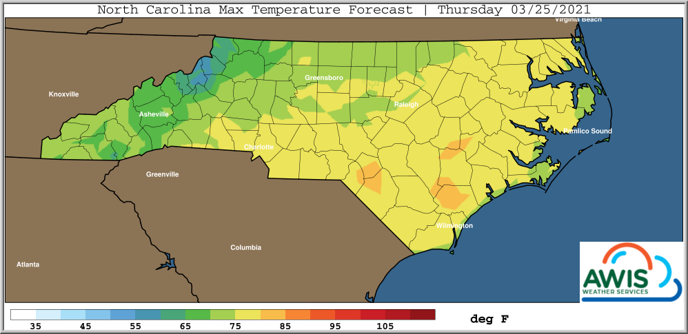
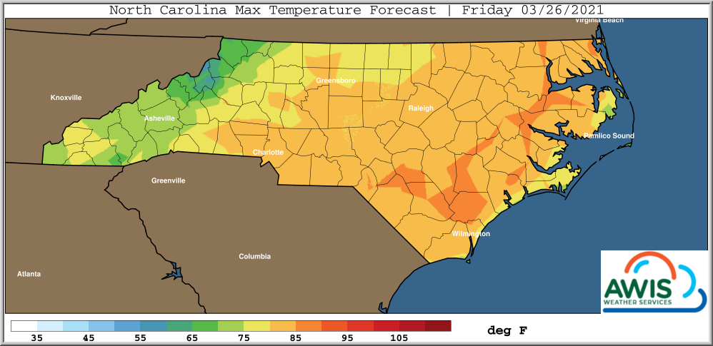
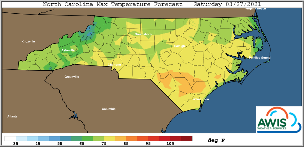
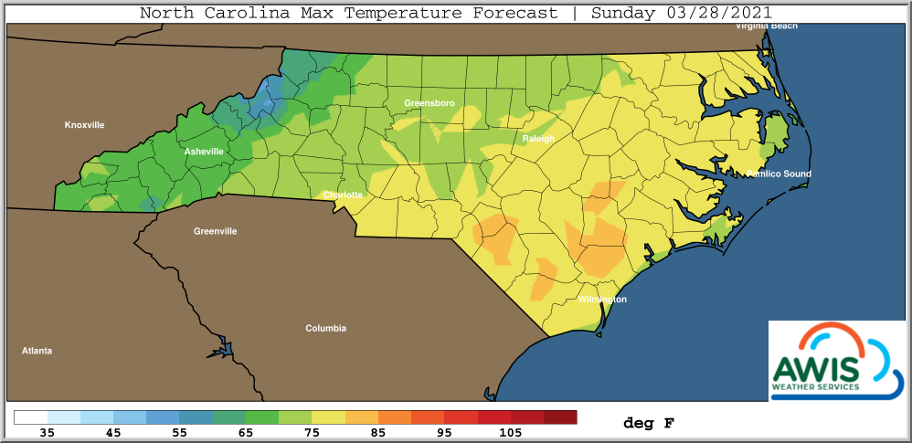
Figure 1: AWIS MAXIMUM Temperatures Forecasts: for North Carolina 3/25-3-28. High Temperatures are especially reached on Friday (3/28/2021). While we think that most areas in North Carolina will be fine and that higher wind speeds may provide some release from heat stress, growers in the Southeastern Plains could consider to drip irrigate in the morning for a few hours to cool down the crop and reduce heat stress. Please read this article if you need more guidance.
Chance for Frost in Some Regions at the East Coast Early Next Week
It will cool down some on Monday. By then, blooms should be out and frost protection gear (row-covers and sprinkler systems) need to be in the field! We highly recommend to have an integrated approach using both, row covers and sprinklers.
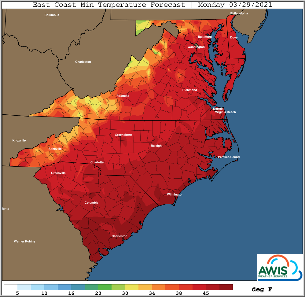
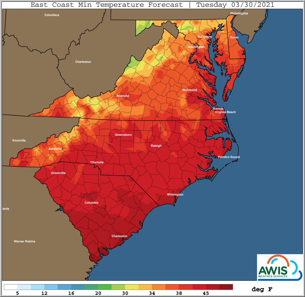
Figure 2: AWIS Minimum Temperatures Forecasts for the region 3/29-3/30. Lower minimum temperatures in northern North Carolina and northern states might increase the risk of frost for nights from Sunday to Monday and Monday to Tuesday.
High Wind Speeds for the Coming Days: Secure Your Row Covers
High windspeeds with 20-30mph wind gusts are moving in later today and will stay in our region until Saturday. We recommend securing your row covers now!
Hourly Forecasts
North Carolina
South Carolina
Georgia
Virginia
Maryland
This post was created under the consultation of AWIS Weather Services and Dr. Barclay Poling.