


AWIS Frost Update for North Carolina, MD, VA, SC, GA and KY (5pm, Friday, March 16, 2018)
go.ncsu.edu/readext?516526
en Español / em Português
El inglés es el idioma de control de esta página. En la medida en que haya algún conflicto entre la traducción al inglés y la traducción, el inglés prevalece.
Al hacer clic en el enlace de traducción se activa un servicio de traducción gratuito para convertir la página al español. Al igual que con cualquier traducción por Internet, la conversión no es sensible al contexto y puede que no traduzca el texto en su significado original. NC State Extension no garantiza la exactitud del texto traducido. Por favor, tenga en cuenta que algunas aplicaciones y/o servicios pueden no funcionar como se espera cuando se traducen.
Português
Inglês é o idioma de controle desta página. Na medida que haja algum conflito entre o texto original em Inglês e a tradução, o Inglês prevalece.
Ao clicar no link de tradução, um serviço gratuito de tradução será ativado para converter a página para o Português. Como em qualquer tradução pela internet, a conversão não é sensivel ao contexto e pode não ocorrer a tradução para o significado orginal. O serviço de Extensão da Carolina do Norte (NC State Extension) não garante a exatidão do texto traduzido. Por favor, observe que algumas funções ou serviços podem não funcionar como esperado após a tradução.
English
English is the controlling language of this page. To the extent there is any conflict between the English text and the translation, English controls.
Clicking on the translation link activates a free translation service to convert the page to Spanish. As with any Internet translation, the conversion is not context-sensitive and may not translate the text to its original meaning. NC State Extension does not guarantee the accuracy of the translated text. Please note that some applications and/or services may not function as expected when translated.
Collapse ▲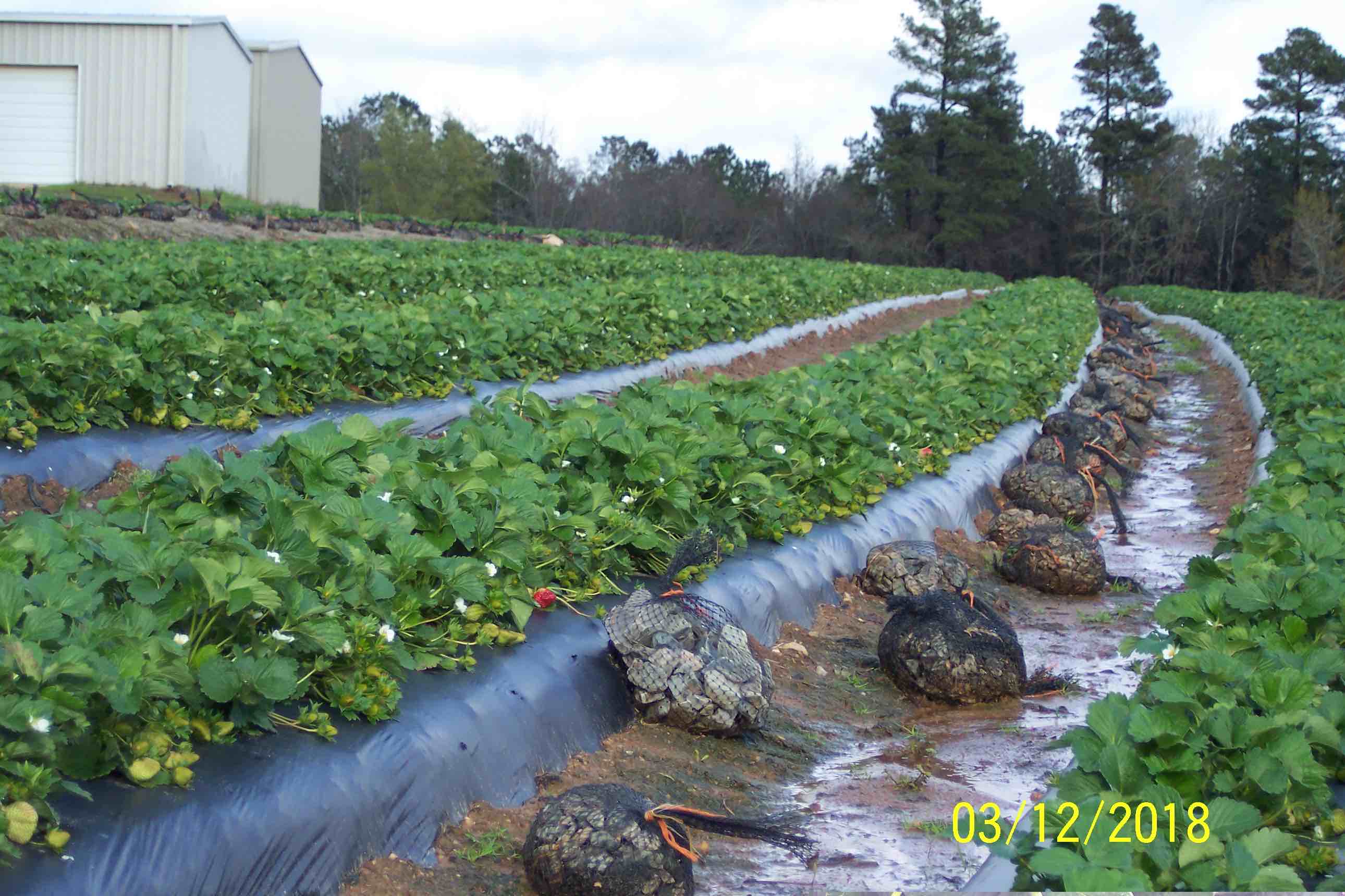
Fig. 1. Clyde Gurosik sent this photo of his Camarosa crop on March 12th – he is located in N. Augusta, SC. He wrote, “…Camarosa cut-off plants…should begin production by 3/23/18 and be in HIGH COTTON before Easter and Masters week.
Total cold protection has been with overhead irrigation protection. No row covers were ever deployed, as labor wasn’t available to perform necessary, desired “TIMELY REMOVALS”!! Rock bags were deployed, so covers could be, IF a “CLIPPER” was expected.”
Good afternoon,
I just got through reading Mark’s terrific update from yesterday – nice work!
Mark provided a very useful set of instructions (with great graphics) on using the CRONOS system – not only for NC, but other states as well.
I am also pleased to see how much attention Mark is giving to wind speeds in most all of his advisories! I recall Clyde Gurosik saying to me not too long ago how ultra-critical it is to have good wind speed information in REAL TIME – in case you are interested this is the type of Real Time Graphical information Clyde is getting from the Clarks Hill-SC weather station Georgia Weather – Automated Environmental Monitoring Network Page
NC Grower emphasizes “Know Your Location.” Mark and I received this note from Scot Luton today:
“Good morning from Roper,NC. I just wanted to share how varied temps can be here up Backwoods. SkyBit called for canopy of 39 degrees and an air temp of 42. AWIS called for a minimum air temp of 42 degrees for Edenton,NC and 37 degrees for Ahoskie,NC. I am also a big fan of CRONOS and I am about 5 miles from the ECONET site on the Tidewater Research Station ,Plymouth,NC. The temp there at 6 a.m. was 45.9 degrees at 2m and the wind was 5.9 mph. At 1500 Backwoods RD Roper,NC [home] it was34.5 degrees at eye level,31 degrees at canopy level and calm. Frost was forming on the covers and if we had not been covered I would have started irrigation. I can understand why new growers get confused about forecast.We have been raising strawberries here since 1973.Daddy bought the irrigation system we still use in1973 for frost protection.A lot of things have changed since we planted the first strawberry here,but one thing has remained constant, Daddy still says this is just a cold hole. I guess if there’s a lesson in all this rambling it would be KNOW YOUR LOCATION. Scot Luton Roper,NC
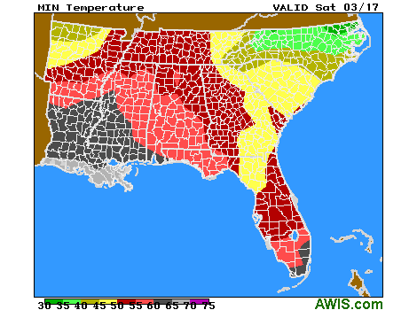
Fig. 2. Min Temp Map for Saturday morning, 3/17

10-DAY DETAILED HOURLY WEATHER FORECASTS
AWIS Weather Services, Inc. North Carolina Frost/Freeze Forecast
Produced at  307 p.m. CDT on Fri Mar 16 2018

... Forecast for Tonight ... Northeast NC Coast
Currituck/Camden/Pasquotank/Tyrrell Counties

**** FREEZE COLD LOCATIONS  ****
****  FROST LIKELY  ****

Lowest Temperatures:      31 - 39
Elizabeth_City Min          31
Durations at/below 32:     0 -  2
Range Dewpoint Temps:     18 - 37
Range Wetbulb  Temps:     31 - 44
AVG Wind Direction/Speed:   N  4     Long Periods of Calm
AVG Sky Condition:     Partly Cloudy

Extended Forecast: Range of Lowest Min Temperatures in the Above Zones
Min Temps Valid For Morning of Given Date (May NOT include ALL cold pockets)

  03/18/18  03/19/18  03/20/18  03/21/18  03/22/18  03/23/18
  --------  --------  --------  --------  --------  --------
   37 - 45   34 - 44   48 - 54   45 - 51   34 - 40   32 - 40
--------

East Central/SE NC Coast
Carteret/Pamlico Counties

**** NEAR FREEZING COLD LOCATIONS  ****
****  FROST LIKELY  ****

Lowest Temperatures:      35 - 41
Morehead_City Min           41
Range Dewpoint Temps:     24 - 39
Range Wetbulb  Temps:     39 - 47
AVG Wind Direction/Speed:  NW  4     Long Periods of Calm
AVG Sky Condition:     Partly Cloudy

Extended Forecast: Range of Lowest Min Temperatures in the Above Zones
Min Temps Valid For Morning of Given Date (May NOT include ALL cold pockets)

  03/18/18  03/19/18  03/20/18  03/21/18  03/22/18  03/23/18
  --------  --------  --------  --------  --------  --------
   46 - 49   38 - 43   52 - 55   45 - 53   35 - 39   34 - 37
--------

Southeast NC
NWS FORECAST ZONES 87-90,96-101
** PATCHY FROST COLDEST LOCATIONS **

Lowest Temperatures:      36 - 45
Elizabethtown Min           41
Range Dewpoint Temps:     23 - 44
Range Wetbulb  Temps:     41 - 49
AVG Wind Direction/Speed:  NE  4     Long Periods of Calm
AVG Sky Condition:     Partly Cloudy

Extended Forecast: Range of Lowest Min Temperatures in the Above Zones
Min Temps Valid For Morning of Given Date (May NOT include ALL cold pockets)

  03/18/18  03/19/18  03/20/18  03/21/18  03/22/18  03/23/18
  --------  --------  --------  --------  --------  --------
   46 - 51   41 - 47   52 - 57   43 - 51   36 - 40   32 - 36
--------

North-Central NC
Franklin County Area

**** FREEZE COLD LOCATIONS  ****
**** LITTLE/NO FROST DUE TO DRY AIR ****

Lowest Temperatures:      32 - 41
Louisburg Min               33
Durations at/below 32:     0 -  1
Range Dewpoint Temps:     12 - 26
Range Wetbulb  Temps:     31 - 40
AVG Wind Direction/Speed:  NW  3     Long Periods of Calm
AVG Sky Condition:     Partly Cloudy

Extended Forecast: Range of Lowest Min Temperatures in the Above Zones
Min Temps Valid For Morning of Given Date (May NOT include ALL cold pockets)

  03/18/18  03/19/18  03/20/18  03/21/18  03/22/18  03/23/18
  --------  --------  --------  --------  --------  --------
   39 - 48   37 - 47   43 - 52   40 - 48   31 - 38   29 - 35
--------

North/Central NC
Alamance County Area

**** NEAR FREEZING COLD LOCATIONS  ****
**** LITTLE/NO FROST DUE TO DRY AIR ****

Lowest Temperatures:      35 - 40
Graham_AG Min               37
Range Dewpoint Temps:     18 - 26
Range Wetbulb  Temps:     33 - 40
AVG Wind Direction/Speed:  NW  3     Long Periods of Calm
AVG Sky Condition:     Partly Cloudy

Extended Forecast: Range of Lowest Min Temperatures in the Above Zones
Min Temps Valid For Morning of Given Date (May NOT include ALL cold pockets)

  03/18/18  03/19/18  03/20/18  03/21/18  03/22/18  03/23/18
  --------  --------  --------  --------  --------  --------
   42 - 48   42 - 47   45 - 50   42 - 47   33 - 38   30 - 35
--------

South/Central NC
Richmond County Area
**** LITTLE/NO FROST DUE TO DRY AIR ****

Lowest Temperatures:      38 - 43
Ellerbe Min                 41
Range Dewpoint Temps:     23 - 39
Range Wetbulb  Temps:     41 - 46
AVG Wind Direction/Speed:  NW  5     Long Periods of Calm
AVG Sky Condition:     Mostly Cloudy

Extended Forecast: Range of Lowest Min Temperatures in the Above Zones
Min Temps Valid For Morning of Given Date (May NOT include ALL cold pockets)

  03/18/18  03/19/18  03/20/18  03/21/18  03/22/18  03/23/18
  --------  --------  --------  --------  --------  --------
   47 - 49   42 - 46   45 - 54   40 - 47   33 - 38   31 - 35
--------

Interior/EC-SE NC
Wayne County Area

**** NEAR FREEZING COLD LOCATIONS  ****
****  FROST LIKELY  ****

Lowest Temperatures:      34 - 40
Goldsboro_AG Min            38
Range Dewpoint Temps:     21 - 40
Range Wetbulb  Temps:     41 - 43
AVG Wind Direction/Speed:  NW  3     Long Periods of Calm
AVG Sky Condition:     Partly Cloudy

Extended Forecast: Range of Lowest Min Temperatures in the Above Zones
Min Temps Valid For Morning of Given Date (May NOT include ALL cold pockets)

  03/18/18  03/19/18  03/20/18  03/21/18  03/22/18  03/23/18
  --------  --------  --------  --------  --------  --------
   43 - 48   37 - 43   50 - 55   43 - 52   34 - 38   32 - 35
--------

For more detailed information visit www.awis.com or call 888-798-9955. Copyright 2018 AWIS Weather Services, Inc. All rights reserved.
Maryland
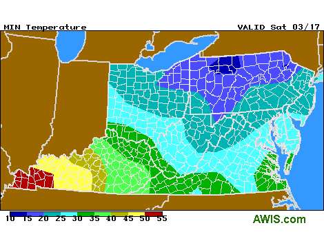 Fig. 3. AWIS Minimums for MD and Mid-Atlantic (includes VA)
10-DAY DETAILED HOURLY WEATHER FORECASTS FOR MD
Virginia
Note from Lowell Yoder in Rustburg, VA
Howdy sir. No, we actually aren’t nearly as advanced as many of the folks to our south and east. You can find some scattered blooms on some sweet Charlie’s and a rare one on the chandlers. Most of the sweet Charlie’s have buds emerged from the crown. My chandlers mostly have buds right at the top of the crown or still inside. I have all my sweet Charlie’s and Albions covered and have for the last week and a half trying to push them. I covered half of my chandlers over the weekend but the other half remain uncovered. Hoping to stagger them some. Half of my chandlers were only covered a month or so through the harshest winter weather.It’s easy to get antsy when I see the pictures of blooms from North Carolina and try to rush things. But with the weather we’ve had and some still to go I’m glad we’re no further along then we are. It’s not a sprint but a marathon. 😁
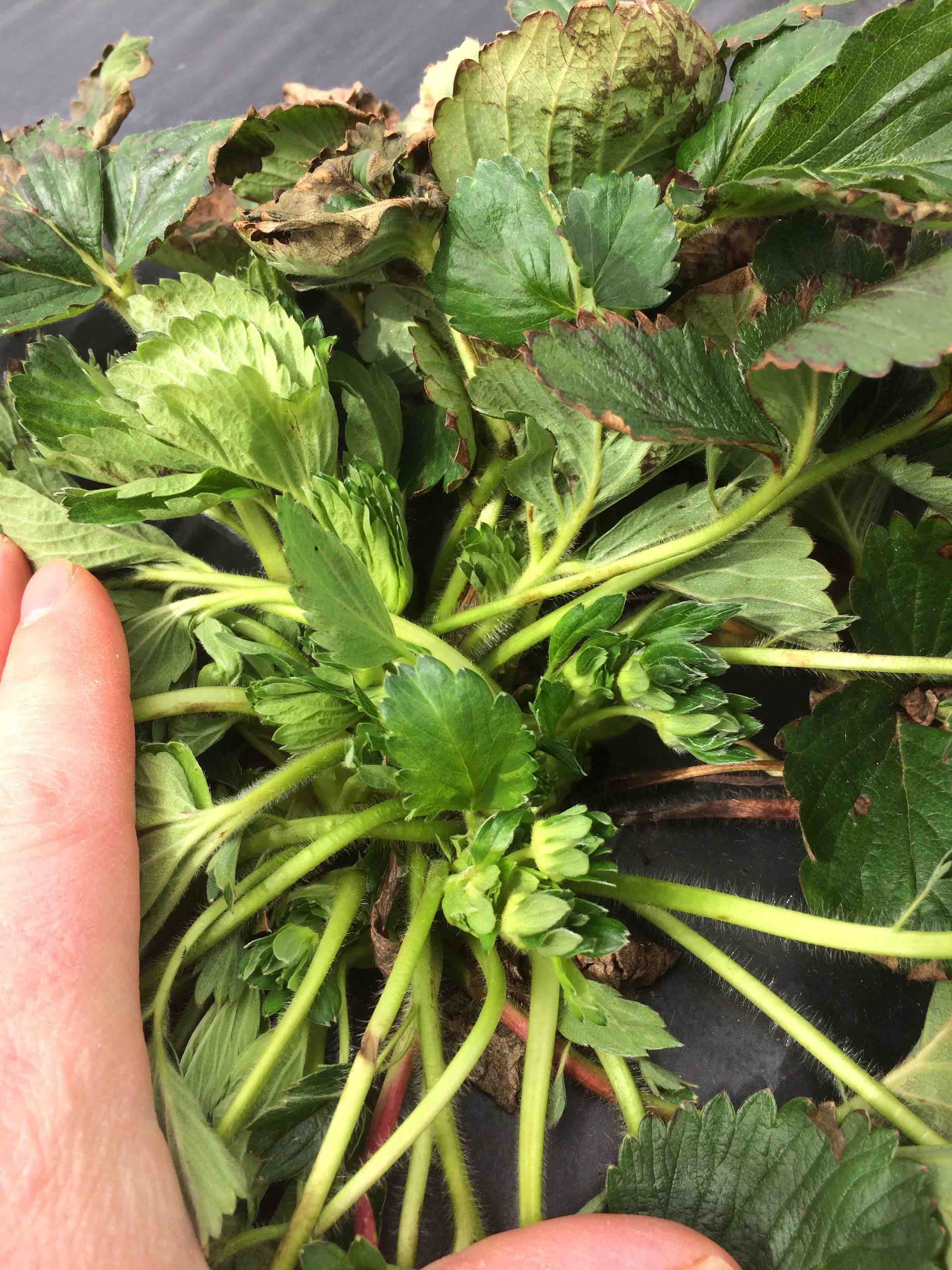 Fig. 4. Sweet Charlie on March 14th in Rustburg, VA (near Lynchburg)
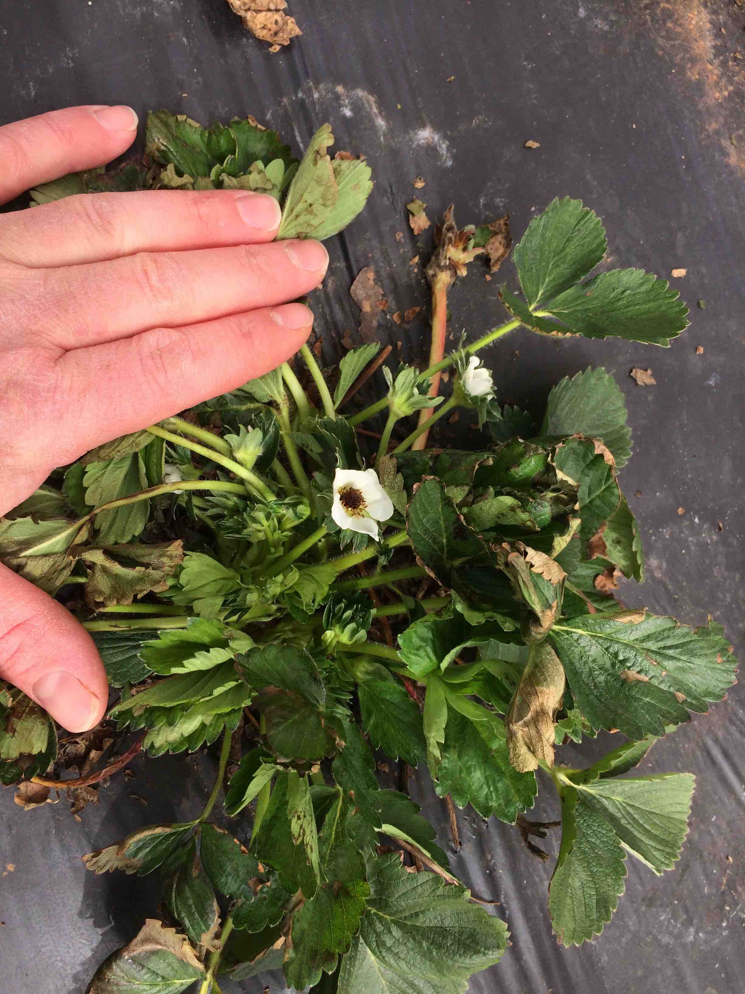 Fig. 6. Another Sweet Charlie plant
10-DAY DETAILED HOURLY WEATHER FORECASTS (VA)
South Carolina
Eric Hunter, Easley, SC, wrote on 3/14: The winds have been horrible here for the past few days. So far everything is coming through the cold pretty good. We’ve had lows in the mid 20s.
Note written by Clyde Gurosik on 3/14 Clydes note 3:14
 10-DAY DETAILED HOURLY WEATHER FORECASTS
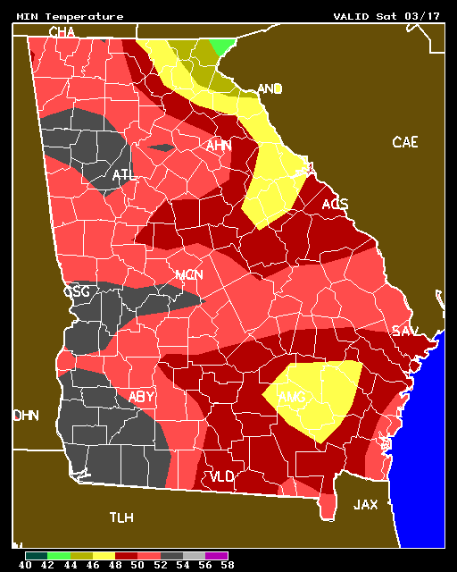
Georgia – looking pretty safe! GA Frost Forecast
10-DAY DETAILED HOURLY WEATHER FORECASTS
Kentucky KY Frost Forecast Tonight
10-DAY DETAILED HOURLY WEATHER FORECASTS
Have a good evening!