AWIS Weather Advisory 3/18/2021: Storm, Rain and a Chance for Frost
go.ncsu.edu/readext?783251
en Español / em Português
El inglés es el idioma de control de esta página. En la medida en que haya algún conflicto entre la traducción al inglés y la traducción, el inglés prevalece.
Al hacer clic en el enlace de traducción se activa un servicio de traducción gratuito para convertir la página al español. Al igual que con cualquier traducción por Internet, la conversión no es sensible al contexto y puede que no traduzca el texto en su significado original. NC State Extension no garantiza la exactitud del texto traducido. Por favor, tenga en cuenta que algunas aplicaciones y/o servicios pueden no funcionar como se espera cuando se traducen.
Português
Inglês é o idioma de controle desta página. Na medida que haja algum conflito entre o texto original em Inglês e a tradução, o Inglês prevalece.
Ao clicar no link de tradução, um serviço gratuito de tradução será ativado para converter a página para o Português. Como em qualquer tradução pela internet, a conversão não é sensivel ao contexto e pode não ocorrer a tradução para o significado orginal. O serviço de Extensão da Carolina do Norte (NC State Extension) não garante a exatidão do texto traduzido. Por favor, observe que algumas funções ou serviços podem não funcionar como esperado após a tradução.
English
English is the controlling language of this page. To the extent there is any conflict between the English text and the translation, English controls.
Clicking on the translation link activates a free translation service to convert the page to Spanish. As with any Internet translation, the conversion is not context-sensitive and may not translate the text to its original meaning. NC State Extension does not guarantee the accuracy of the translated text. Please note that some applications and/or services may not function as expected when translated.
Collapse ▲AWIS Weather Advisory 3/18/2021: The Coming Days Entail Storm, Rain and a Chance of Frost
Dear all,
Sever storms tonight will be followed by rain and colder temperatures this weekend. This puts growers into a rough spot, where row-covers need to be off the plants and secured, and probably be put back on for the night of Friday to Saturday.
AWIS General Weather Discussion
Strong to severe storms were ongoing this morning across
Georgia and points Northward into Virginia. These should push
offshore by this evening. Rain was more steady North of there
in the colder air, and that may linger through Friday.
Rain totals from this system will be mostly under 1 inch Southern
areas to locally 1-2 inches Northern areas. However, colder high pressure builds in behind that for this weekend.
Thus the freeze threat this weekend will be highest from inland
areas of VA, Northward through MD and DE, where some areas may
see minimums in the mid 20s ranges. Dew points are low enough for areas further South to be of some concern. At the moment it looks like most areas should hold close to 30 and above given some wind and clouds.
Discussion by Karl Harker – AWIS Weather Service
Frost Possibility in Several Areas Across the East Coast Over the Weekend
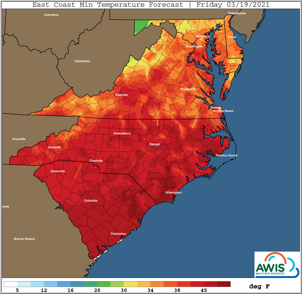
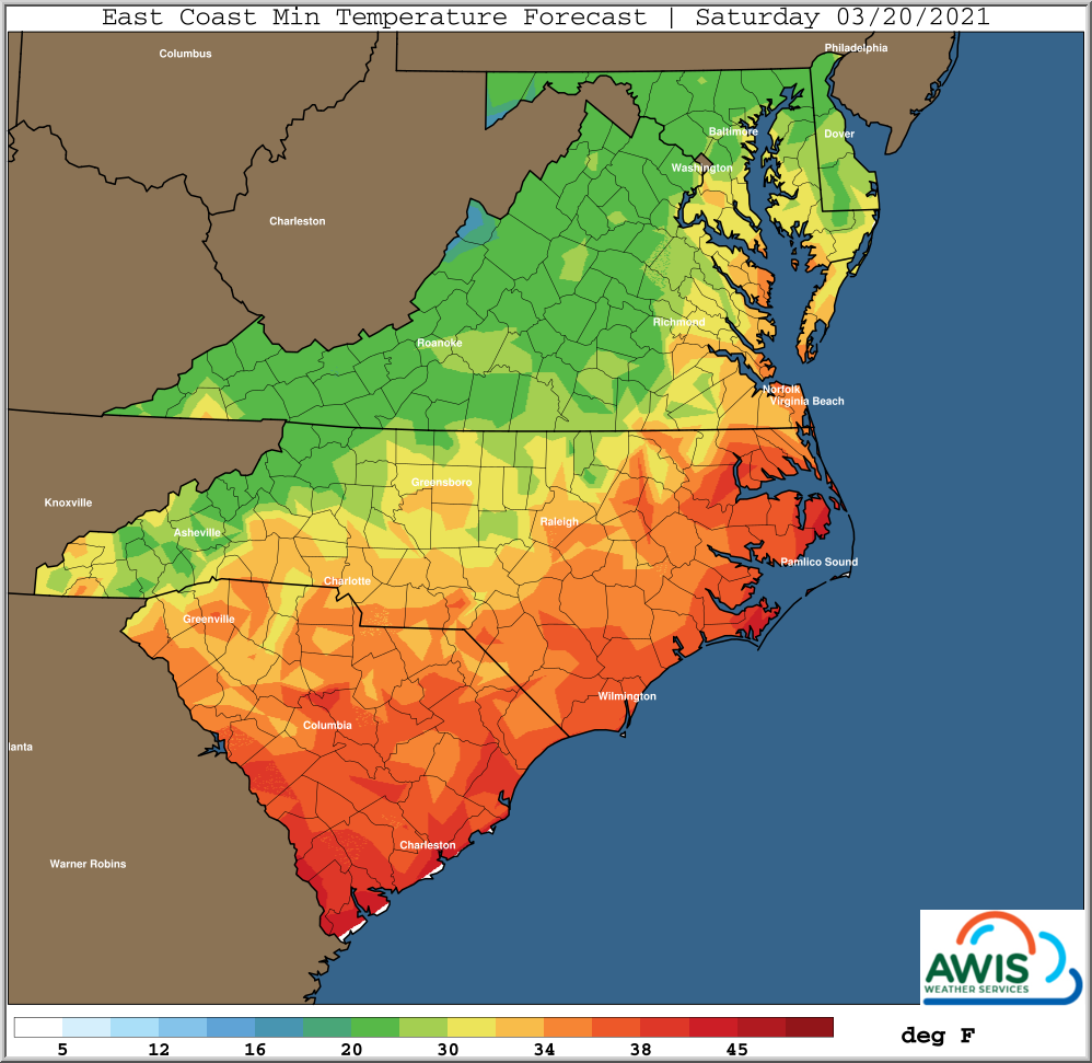
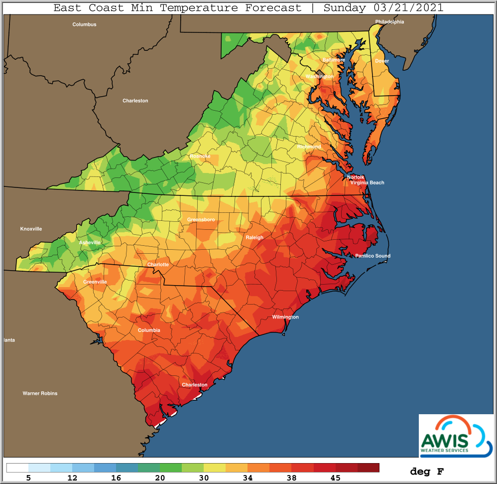
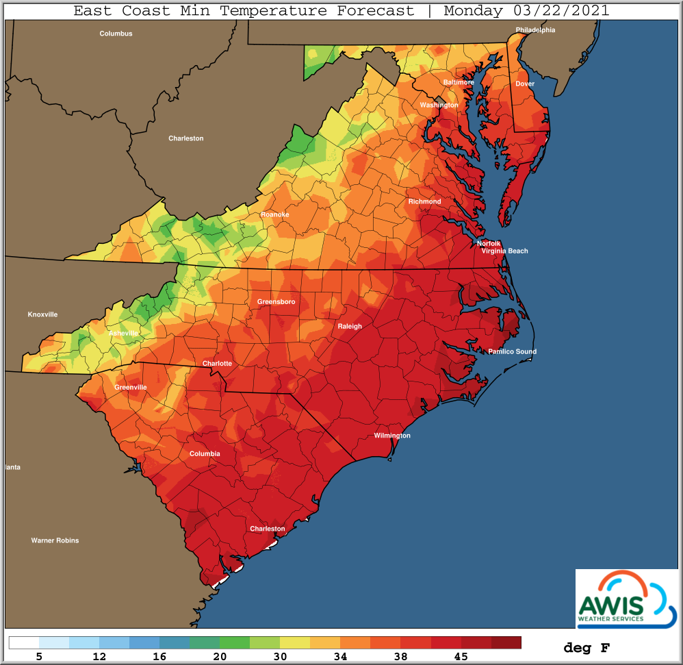
If you haven’t already, please take your row-covers and secure them in a save space. There will be more severe wind in Eastern North Carolina later today. As discussed above, temperatures will drop over the weekend (Figure 1). While I don’t think there will be a severe risk for frost in Eastern North Carolina, growers in areas in the North Carolina piedmont, in VA and North need to be concerned and use row-covers to protect flowers.
Figure 1: AWIS Minimum Temperature Forecast for parts of the East Coast over the coming four days. Colder nights are expected on Saturday and Sunday, Secure you row covers today! Graphs by Tim Rinser – AWIS Weather Service
Hourly Forecasts for a Few Regions
North Carolina:
South Carolina:
Georgia:
Virginia:
Maryland:


