


AWIS Weather Forecast Weekend 4/6-4/10
go.ncsu.edu/readext?519866
en Español / em Português
El inglés es el idioma de control de esta página. En la medida en que haya algún conflicto entre la traducción al inglés y la traducción, el inglés prevalece.
Al hacer clic en el enlace de traducción se activa un servicio de traducción gratuito para convertir la página al español. Al igual que con cualquier traducción por Internet, la conversión no es sensible al contexto y puede que no traduzca el texto en su significado original. NC State Extension no garantiza la exactitud del texto traducido. Por favor, tenga en cuenta que algunas aplicaciones y/o servicios pueden no funcionar como se espera cuando se traducen.
Português
Inglês é o idioma de controle desta página. Na medida que haja algum conflito entre o texto original em Inglês e a tradução, o Inglês prevalece.
Ao clicar no link de tradução, um serviço gratuito de tradução será ativado para converter a página para o Português. Como em qualquer tradução pela internet, a conversão não é sensivel ao contexto e pode não ocorrer a tradução para o significado orginal. O serviço de Extensão da Carolina do Norte (NC State Extension) não garante a exatidão do texto traduzido. Por favor, observe que algumas funções ou serviços podem não funcionar como esperado após a tradução.
English
English is the controlling language of this page. To the extent there is any conflict between the English text and the translation, English controls.
Clicking on the translation link activates a free translation service to convert the page to Spanish. As with any Internet translation, the conversion is not context-sensitive and may not translate the text to its original meaning. NC State Extension does not guarantee the accuracy of the translated text. Please note that some applications and/or services may not function as expected when translated.
Collapse ▲Dear all,
Many of you have contacted Barclay or me over the last few days and Barclay must have worked his fingers to the bone, posting several forecasts every day. Thank you! In summary: We hoped to get around this, but as it turns out, we will face some pretty cold and wet nights and mornings over the coming days, with rain moving into Raleigh right now!
Is it another Easter Freeze?
Scot Luton from Roper NC was – like many others – concerned to see signs for another freeze on the horizon. The fact that the predicted colder temperatures are incidentally fall on the same dates as the Easter freeze in 2007 made things even more mysterious.
However, neither the conditions we will face over the next few days nor the Easter freeze in 2007 are part of a mystery. In fact they can be explained logically. And more important: they are are not similar, they are rather quite different.
The Easter freeze In April 3-10 2007 was a cold wave and blasted much of the central Plains, Midwest and Southeast with Arctic air. This weather condition affected winter wheat across the central Plains and Midwest, blooming fruits and emerging corn across parts of the Midwest and southern U.S.
See this link for more information:
Situation for the coming days
The situation of the Easter freeze in 2007 was different to what we will experience over the next few days. First of all, the first three months of this year 2018 were no record months. In North Carolina, we were 0.8 F above average temperature, which makes is pretty much: average. So we didn’t experience a stable ridge of high pressure in March, so no cold air was forced to stay in the Arctic.
Secondly, and more importantly, although there is cold air moving in, it’s not at record breaking temperatures (which is good!). Currently a big storm did build up at the lines of a high pressure and a low pressure field. The high pressure field keeps mostly cold air over northeast Canada and the Atlantic, while the low pressure field keeps high temperatures (south). This storm is currently bringing snow to the norther parts of Eastern U.S. and over Friday night, Saturday will move towards the Southeast, bringing snow into Virginia and Maryland, wet snow in south Virginia and the northern parts of North Carolina and rain to most of the rest of the Southeast (see Figure 1).
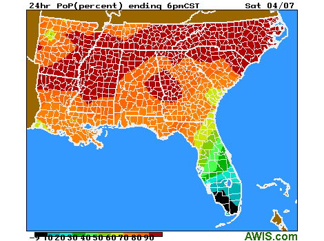
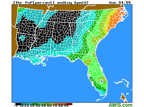
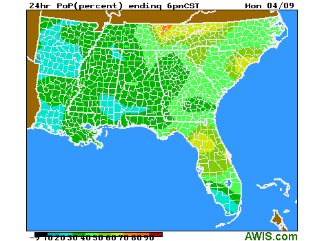
Figure 1: Percent Chance of Rain/Snow Fall from Sat 4/7/2018- Mon 4/9/2018
The storm also brings wet, cold air from Canada to the Southeast, which joins rain currently moving from Alabama and Mississippi towards the East. The unusual thing about this is, that we will face wet AND cold conditions at the same time (Figure 2, 3)
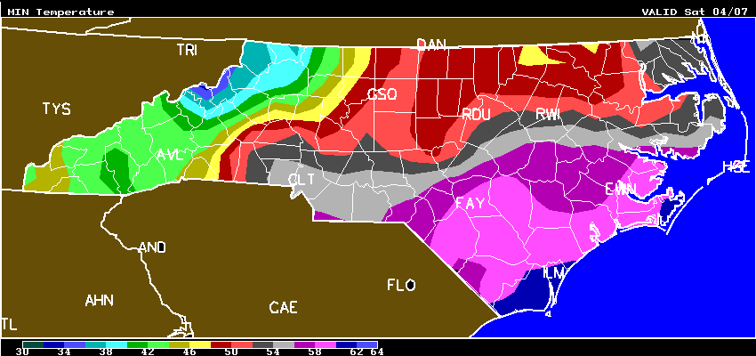
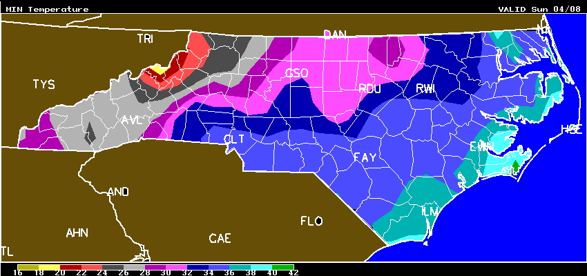
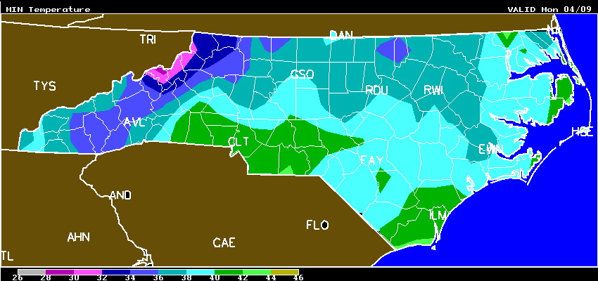
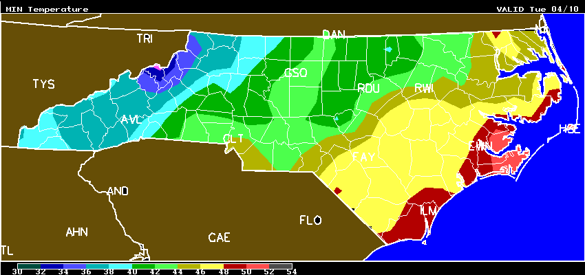
Figure 2: Minimum Temperatures for NC from Sat, 04/07/2018 – Tue, 04/10/2018. Sunday and Monday night will be the coldest!
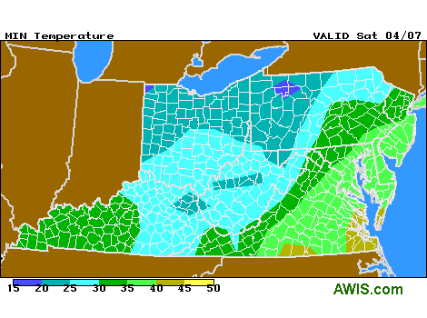
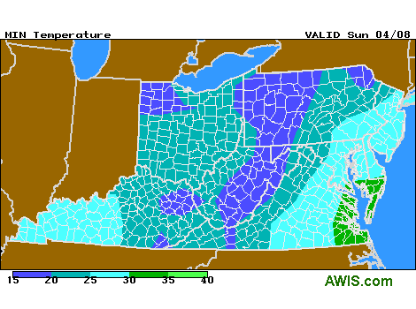
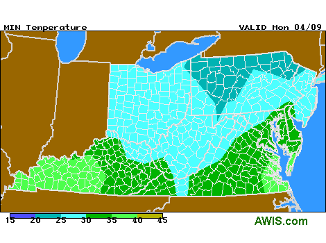
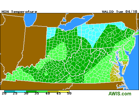
Figure 3: Minimum Temperatures for VA from Sat, 04/07/2018 – Tue, 04/10/2018.
Which temperature is critical?
As always, the temperatures on your blossoms might be lower to the forecast air temperatures. Freeze and thaw processes in plants are very complex and usually start from within the plant. Our recent experiments on strawberries confirm that. Flowers start to freeze at around 26 F (‘Camarosa’) under low humidity. The receptacle continues to freeze until temperature reach 24-23 F. However, that might be quite different at high humidity conditions. As Barclay indicated correctly, your plants should be protected by now, if the predicted min AIR temperatures are in the low 30s’.
Protection:
Wet AND cold is a problem for row covers. If you are in a place, where temperatures are dropping below 32 after the rain, please follow Barclay’s recommendations: Let it rain on the covers and have a secondary protection in place! Otherwise covers will freeze and can damage your blossoms.
If temperatures drop, a secondary heat source (sprinkler) will also help to protect your blooms.
5-Day Forecast:
NC:
VA:
MD:
SC:
GA:
As always I hope that helps and I hope we all get safe through the coming days. Please contact Barclay, me or your local extension agent if you have questions.
Mark