


Frost and Frost / Freeze Conditions in WNC (4/17/10)
go.ncsu.edu/readext?1643
en Español / em Português
El inglés es el idioma de control de esta página. En la medida en que haya algún conflicto entre la traducción al inglés y la traducción, el inglés prevalece.
Al hacer clic en el enlace de traducción se activa un servicio de traducción gratuito para convertir la página al español. Al igual que con cualquier traducción por Internet, la conversión no es sensible al contexto y puede que no traduzca el texto en su significado original. NC State Extension no garantiza la exactitud del texto traducido. Por favor, tenga en cuenta que algunas aplicaciones y/o servicios pueden no funcionar como se espera cuando se traducen.
Português
Inglês é o idioma de controle desta página. Na medida que haja algum conflito entre o texto original em Inglês e a tradução, o Inglês prevalece.
Ao clicar no link de tradução, um serviço gratuito de tradução será ativado para converter a página para o Português. Como em qualquer tradução pela internet, a conversão não é sensivel ao contexto e pode não ocorrer a tradução para o significado orginal. O serviço de Extensão da Carolina do Norte (NC State Extension) não garante a exatidão do texto traduzido. Por favor, observe que algumas funções ou serviços podem não funcionar como esperado após a tradução.
English
English is the controlling language of this page. To the extent there is any conflict between the English text and the translation, English controls.
Clicking on the translation link activates a free translation service to convert the page to Spanish. As with any Internet translation, the conversion is not context-sensitive and may not translate the text to its original meaning. NC State Extension does not guarantee the accuracy of the translated text. Please note that some applications and/or services may not function as expected when translated.
Collapse ▲vol 11 no 33
April 17, 2010 (1 p.m.)
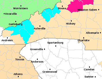
Table 1. A detailed investigation of the NWS Freeze Zone doesn’t support the warning of a FREEZE event, but there is potential for a FROST (white) tomorrow morning in Bryson City and Sylva, and in Wayesville it may be a hybrid cold event involving sustained winds and a brief period below 32 F.
| Sunday morning | Min Temp & | 6 a.m. | Hour when | ||
| Cloud cover | Dewpoint | Winds | Hours< 32 | WB at 31 F | |
| Bryson City | 10% | 36 (30) | 2-3 mph | none | Wb is 34 F |
| Sylva | 10% | 36 (30) | 3 mph | none | WB is 34 |
| Waynesville | 8-11% | 31 (25) | 5-6 mph | 1? | 4:00 a.m. |
| Asheville | 11% | 39 (32) | 7-8 mph | none | WB is 36 F |
| Monday morning | 6 a.m. | Hour when | |||
| Cloud cover | Min Temp | Winds | Hours< 32 | WB at 31 F | |
| Bryson City | 25% | 35 (30) | 1 mph | none | WB is 33 F |
| Sylva | 25% | 34 (29) | 1 mph | none | WB is 32 F |
| Waynesville | 25% | 31 (26) | 1 mph | 1-2? | 2:00 a.m. |
| Asheville | 26% | 37 (30) | 2-3 mph | none | WB is 34 |
URGENT - WEATHER MESSAGE NATIONAL WEATHER SERVICE GREENVILLE-SPARTANBURG SC 424 a.m. EDT SAT APR 17 2010 ...FREEZING TEMPERATURES EXPECTED ACROSS PORTIONS OF THE NORTH CAROLINA MOUNTAINS TONIGHT... .GUSTY NORTHWEST WINDS WILL DEVELOP ACROSS THE MOUNTAINS THIS EVENING FOLLOWING THE PASSAGE OF A COLD FRONT. THE NORTHWEST WINDS WILL BRING MUCH COLDER TEMPERATURES ACROSS THE SOUTHERN APPALACHIANS TONIGHT. TEMPERATURES WILL CONTINUE TO FALL THROUGH TONIGHT...WITH LOWS RANGING FROM THE UPPER 20S TO LOWER 30S ACROSS THE NORTHERN MOUNTAINS AND PORTIONS OF THE SMOKIES. NCZ033-049>052-059-063-172100- /O.NEW.KGSP.FZ.W.0002.100418T0400Z-100418T1300Z/ AVERY-YANCEY-MITCHELL-SWAIN-HAYWOOD-NORTHERN JACKSON- SOUTHERN JACKSON- INCLUDING THE CITIES OF...NEWLAND...SPRUCE PINE...CHEROKEE... WAYNESVILLE...SYLVA 424 a.m. EDT SAT APR 17 2010 ...FREEZE WARNING IN EFFECT FROM MIDNIGHT TONIGHT TO 9 a.m. EDT SUNDAY... THE NATIONAL WEATHER SERVICE IN GREENVILLE-SPARTANBURG HAS ISSUED A FREEZE WARNING...WHICH IS IN EFFECT FROM MIDNIGHT TONIGHT TO 9 a.m. EDT SUNDAY. NORTHWEST WINDS WILL BRING A COLD CANADIAN AIR MASS ACROSS THE SOUTHERN APPALACHIANS TONIGHT. TEMPERATURES WILL FALL STEADILY OVERNIGHT...WITH SEVERAL HOURS OF FREEZING TEMPERATURES EXPECTED ACROSS THE NORTHERN MOUNTAINS AND PORTIONS OF THE SMOKIES AFTER MIDNIGHT TONIGHT. TEMPERATURES SHOULD WARM ABOVE FREEZING SHORTLY AFTER SUNRISE SUNDAY MORNING. PRECAUTIONARY/PREPAREDNESS ACTIONS... A FREEZE WARNING MEANS SUB-FREEZING TEMPERATURES ARE IMMINENT OR HIGHLY LIKELY. THESE CONDITIONS WILL KILL CROPS AND OTHER SENSITIVE VEGETATION.
Agricultural Weather Information Service, Inc. 60-Hr Detailed Forecast For Asheville_Munic, NC
Produced at  508 a.m. CDT on Sat Apr 17 2010

Day length= 13:12 / Sunrise at 6:54 a.m. / Sunset at 8:06 p.m.  EDT

              Saturday     April 17, 2010         Sunday     April 18, 2010
 HR   7  8  9 10 11 12 13 14 15 16 17 18 19 20 21 22 23  0  1  2  3  4  5  6
                            MAX= 73                              MIN= 35
TDB  54 58 62 65 68 70 72 73 73 73 68 63 59 55 52 50 48 48 45 43 41 40 38 36
TDP  46 45 44 43 42 41 41 40 40 40 40 38 36 34 35 35 36 36 35 35 34 34 33 33
TWB  50 51 53 53 54 55 56 56 56 56 53 51 48 45 44 43 43 43 41 40 38 38 36 35
WSD   5  6  7  8  9 10 13 14 14 15 15 15 14 14 13 12 10 10  9  9  9  9  9  9
WDR    NNW      NNW      NNW      NNW      NNW      NNW      NNW      NNW
CLD  SC SC SC SC SC SC CL CL CL CL CL CL CL CL CL CL CL CL CL CL CL CL CL CL
INV  -- -- -- -- -- -- -- -- -- -- -- -- -- --  0  0  1  1  1  2  2  2  3  3
DFR  -- -- -- -- -- -- -- -- -- -- -- -- -- -- -- -- -- -- -- -- -- -- -- --

                Sunday     April 18, 2010         Monday     April 19, 2010
 HR   7  8  9 10 11 12 13 14 15 16 17 18 19 20 21 22 23  0  1  2  3  4  5  6
                            MAX= 64                              MIN= 36
TDB  36 41 46 51 56 59 62 63 64 64 60 57 54 51 49 47 46 45 43 42 41 39 38 37
TDP  32 32 31 30 29 28 27 26 25 25 24 25 25 26 27 29 30 31 31 32 32 32 32 32
TWB  34 37 40 42 44 46 47 47 47 47 45 44 42 41 40 40 39 39 38 38 37 36 36 35
WSD   8  8  9 10 12 13 13 14 14 13 13 12 12 10 12 12 13 10  9  7  7  7  7  7
WDR    NNW        N        N      NNW        N        E      SSW       NE
CLD  CL CL CL CL CL CL CL CL CL CL CL CL CL CL CL CL CL CL CL CL CL CL CL CL
INV   4  2  1  0 -- -- -- -- -- -- -- -- -- --  0  0  0  1  1  2  2  2  3  3
DFR   F -- -- -- -- -- -- -- -- -- -- -- -- -- -- -- -- -- -- -- -- -- -- --
The light blue (38-40) is problematic! The dark green in north central piedmont is not without its potential for frost on Sunday morning should all the conditions needed for frost fall into place, especially light winds and temperatures at the canopy level that get down to below 32 F. You will see that AWIS is allowing the possibility of frost in north central piedmont tomorrow morning - table below
VIRGINIA
You will note there is a very large area covered in dark green for Sunday morning (30-35), so I am afraid this could be a long night for Virginia strawberry growers in these areas where minimums will be below the 37-38 F "frost threshold" and all growers in these areas must set their frost alarms! I would also have it set the in 35-40 range zones as well.
THE SOUTHEAST - SOUTH CAROLINA AND GEORGIA "APPEAR" TO HAVE DODGED THE BULLET, BUT NOT TENNESSEE!
able 2. AWIS FROST/FREEZE FORECAST for April 18 (Sunday morning)
AWIS Weather Services, Inc. North Carolina Frost/Freeze Forecast
Produced at  516 a.m. CDT on Sat Apr 17 2010

... Forecast for Tonight ... Northeast NC Coast
Currituck/Camden/Pasquotank/Tyrrell Counties

*** No Frost And/Or Freeze Danger Tonight ***

--------

East Central/SE NC Coast
Carteret/Pamlico Counties

*** No Frost And/Or Freeze Danger Tonight ***

--------

Southeast NC
NWS FORECAST ZONES 87-90,96-101

*** No Frost And/Or Freeze Danger Tonight ***

--------

North-Central NC
Franklin County Area
** SCATTERED FROST COLDEST LOCATIONS **

Lowest Temperatures:      38 - 47
Louisburg Min               38
Range Dewpoint Temps:     32 - 38
Range Wetbulb  Temps:     37 - 49
AVG Wind Direction/Speed:   N  5     Long Periods of Calm
AVG Sky Condition:     Partly Cloudy
--------

North/Central NC
Alamance County Area
** SCATTERED FROST COLDEST LOCATIONS **

Lowest Temperatures:      39 - 44
Graham_AG Min               42
Range Dewpoint Temps:     30 - 38
Range Wetbulb  Temps:     37 - 49
AVG Wind Direction/Speed:   N  6     Long Periods of Calm
AVG Sky Condition:     Partly Cloudy

--------

South/Central NC
Richmond County Area

*** No Frost And/Or Freeze Danger Tonight ***

Lowest Temperatures:      43 - 47
Ellerbe Min                 47

--------

For more detailed information visit www.awis.com or call 888-798-9955. Copyright 2010 AWIS Weather Services, Inc. All rights reserved.
Good luck
Professor and Extension Specialist (Small Fruits)
Dept. of Horticultural Science
Campus Box 7609
NC State University
Raleigh, NC 27695-7609
919-515-1195
919-515-2505 fax
919-418-9687 cell
email: barclay_poling@ncsu.edu